More than 20 years ago, the City, Province and Federal government jointly embarked on a project to make Toronto’s waterfront a place of local, provincial and national pride and public enjoyment. The tri-government approach led to a vision for the future, and the creation of Waterfront Toronto , to implement a forward-thinking vision for Toronto’s central waterfront.
Through $2.9 billion of tri-government investment, the construction of complete communities and public realm improvements physically transformed Toronto’s central waterfront to bring significant economic, social and environmental benefits to residents and businesses.
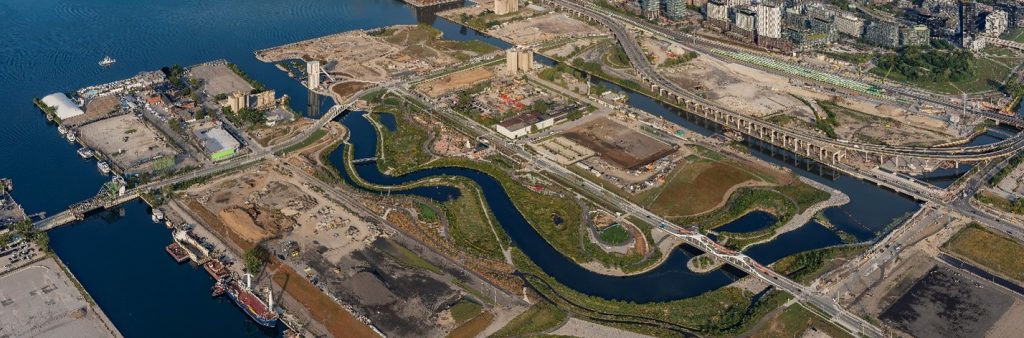
The City, in collaboration with the Government of Canada and the Government of Ontario, working with Waterfront Toronto, are now advancing a Next Phase of this revitalization effort. A $975 million investment will enable future development of housing, build parks and public realm, and advance planning for new destinations and attractions on the waterfront.
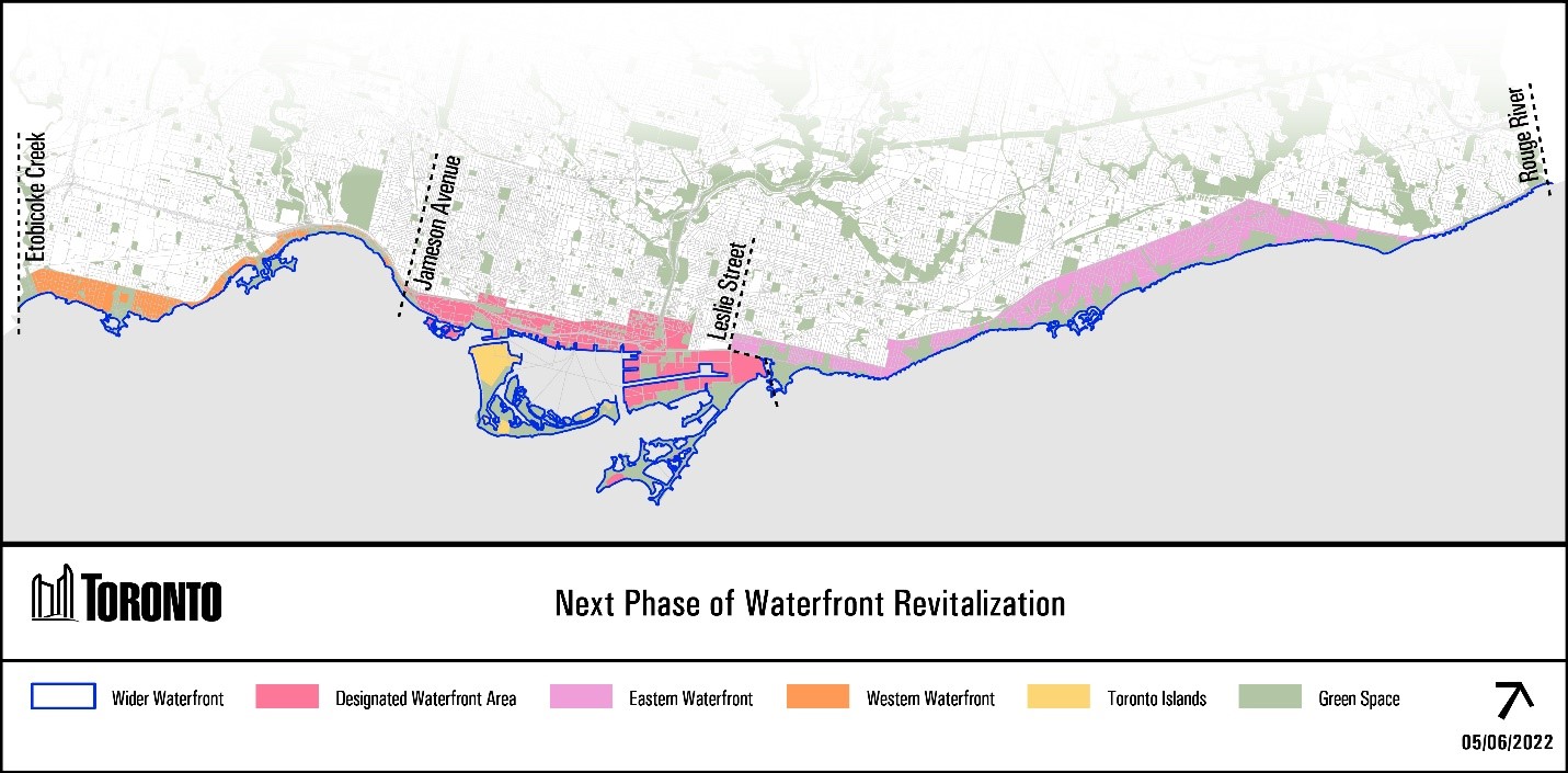
The renewed vision for the next phase of waterfront revitalization will inform the continued transformation of Toronto’s central waterfront, as well as complementary, coordinated investments across the full 43 kilometer span of the City’s wider waterfront, from Etobicoke to Scarborough.
Key projects being advanced through the 2025 announcement of tri-government funding on the next phase of waterfront revitalization include:
A renewed vision aims to address the importance of the waterfront to Indigenous communities and advance City commitments to take meaningful action to advance truth, justice and reconciliation, including through priorities identified in the Reconciliation Action Plan. The next phase of waterfront revitalization will build on engagement with First Nations, Métis and Inuit communities, including Treaty and Territorial partners and urban Indigenous organizations and community members.
A renewed vision will identify specific economic themes that support post-pandemic recovery and deliver on economic, social and environmental outcomes. To date, waterfront revitalization has incorporated innovative approaches to city-building and these approaches will continue to inform precinct planning for future waterfront neighbourhoods, communities and industrial sectors.
A renewed vision provides the opportunity to create a more inclusive waterfront in alignment with City strategies that advance equitable outcomes related to affordable housing, accessible design, racial equity, pedestrian and cycling connections, transit infrastructure and community services. The next phase of waterfront revitalization could be used to ensure that City services, spaces and programs along the waterfront continue to be inclusive and accessible to all Torontonians.
The next phase of waterfront revitalization will embed climate resilience and TransformTO greenhouse gas reduction targets into infrastructure projects (i.e. transit, flood protection) and set a precedent for climate positive design. Ongoing precinct development will advance climate positive design and aquatic habitat restoration while advancing public realm improvements and demonstrating how climate resilient initiatives can flourish along Toronto’s waterfront.
The waterfront has over 12,000 years of history as an important place for Indigenous communities. This is evident in Toronto’s name, derived from the word “Tkaranto,” meaning “where there are trees in the water.” The water and waterfront’s historical, cultural and ongoing significance to Indigenous communities compels the City to take special care and engage in collaborative approaches to the next phase of waterfront revitalization.
Engagement on the next phase of revitalization includes First Nations, Inuit, Métis communities, urban Indigenous organizations and communities as well as Elders, Knowledge Keepers and cultural leaders.
The Indigenous Engagement Summary Report and presentation documents the initial discussions about the next phase of waterfront revitalization with First Nations, Inuit, Métis and urban Indigenous communities, that took place in 2022-2023. City staff and Indigenous engagement consultant, Andrea L.K. Johnston, presented to the Aboriginal Affairs Advisory Committee on June 13, 2022.
These discussions informed the renewed vision and identified opportunities for advancing the Reconciliation Action Plan through waterfront revitalization and restoration projects.
Input heard from Indigenous community engagement continues to inform the planning, design and implementation of various interconnected waterfront projects. Projects include those in the Port Lands, such as the Akinomaagewin Port Lands Indigenous Place Naming Initiative and Biidaasige Park ecological design, art and interpretive features, as well as the Western Beaches Public Realm Plan, and other projects in partnership with Waterfront Toronto (Ookwemin Minising and Quayside public realm design), TRCA (Scarborough Bluffs West Revitalization Study) and CreateTO (McCleary Precinct).
More information on engagement opportunities can be found through the:
Through the 2022 budget cycle, Council approved the creation of staff positions within the Indigenous Affairs Office which are supporting this work, including one staff specifically focused on Indigenous affairs on the waterfront.
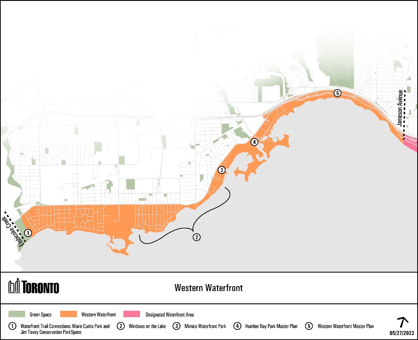
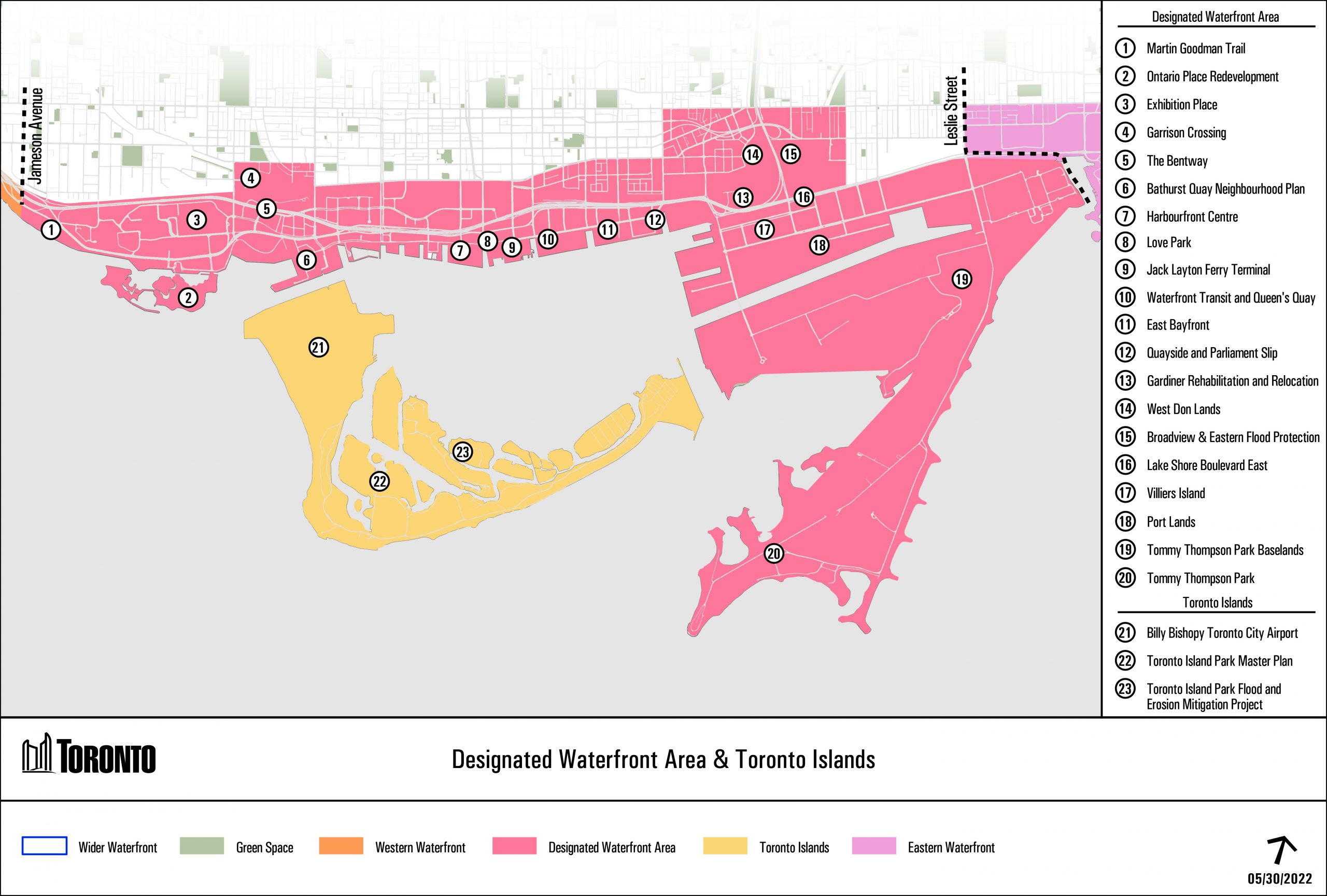
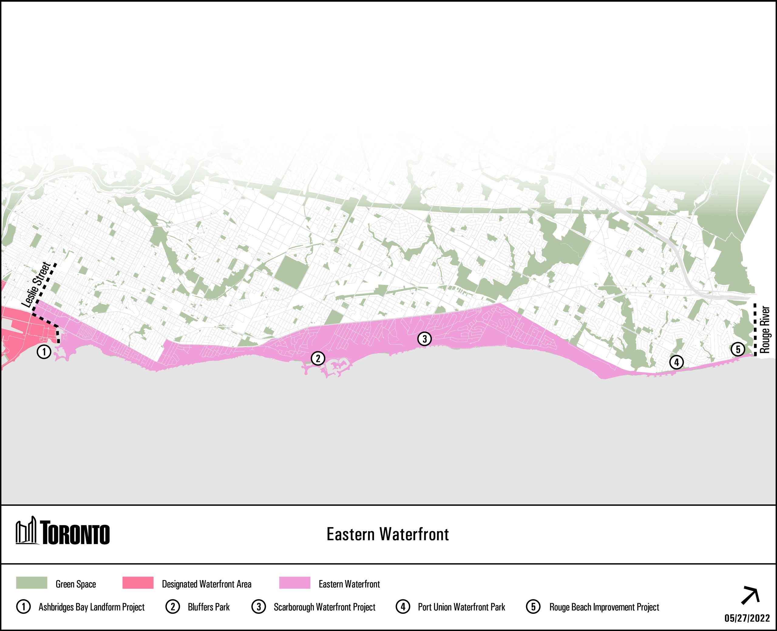
The renewed vision for the next phase of waterfront revitalization expands beyond the Designated Waterfront Area (Central Waterfront), to the Western and Eastern Waterfronts, from Etobicoke to Scarborough. Learn more about the ongoing and future revitalization initiatives below, implemented in partnership between the City of Toronto, Waterfront Toronto, Toronto and Region Conservation Authority and other partners.