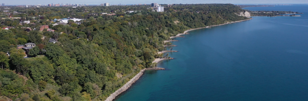
The Scarborough Bluffs West Project will explore the enhancement and protection of sensitive shoreline and natural areas and opportunities for improved waterfront experience and access between the Eastern Beaches (Silver Birch Avenue) and Bluffer’s Park along Lake Ontario. The project will consider opportunities to:
These objectives build on more than five decades of waterfront planning, including consistent policy direction around equity and access to and along the waterfront, desire for a continuous waterfront trail across the city, recreational opportunities and protection and enhancement of the natural environment.
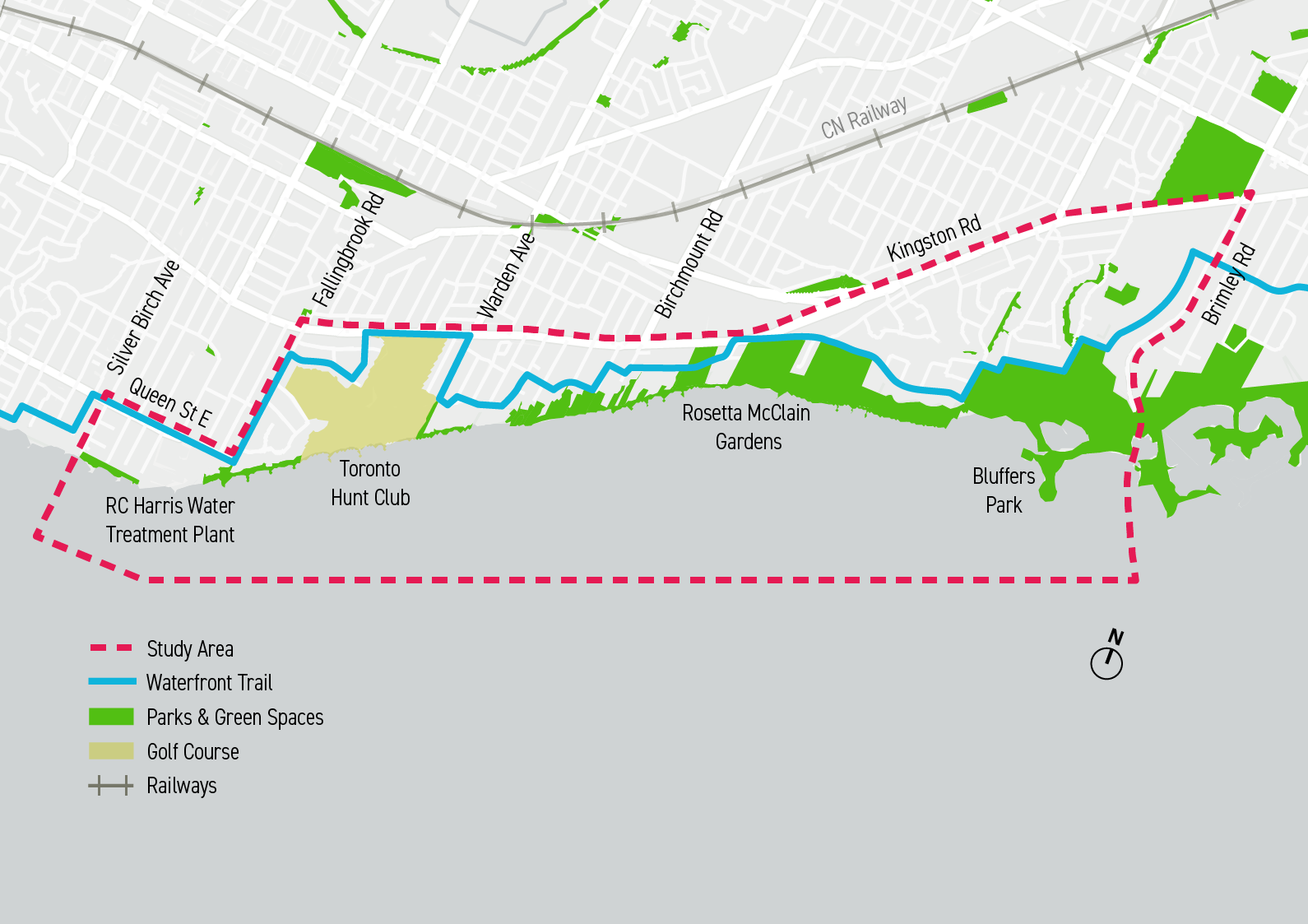
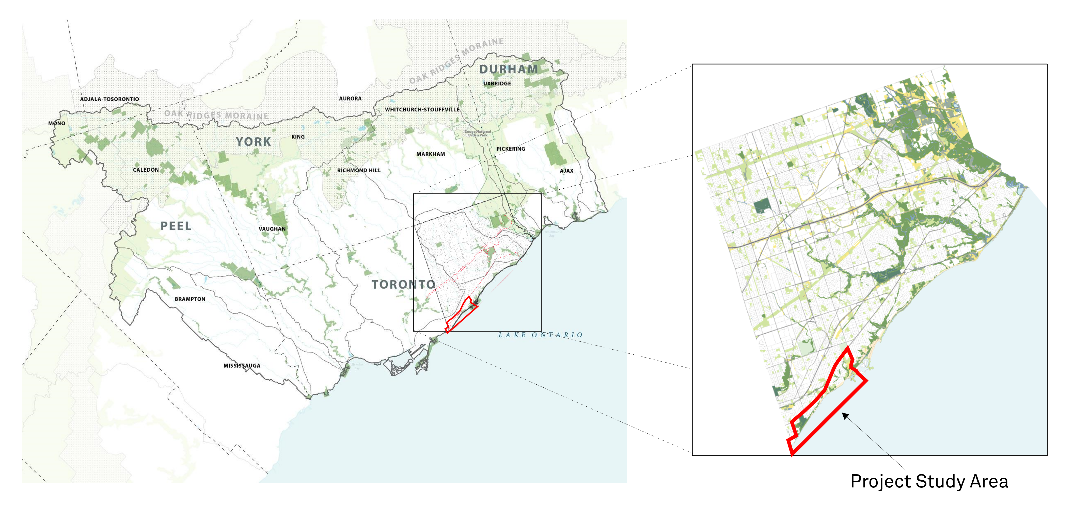
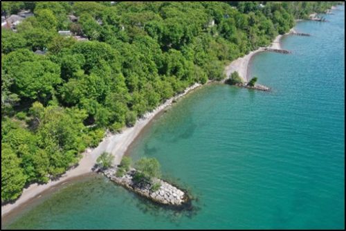
The study area extends from Kingston Road to Lake Ontario, and from Silver Birch Avenue to Brimley Road.
 The Scarborough Bluffs West shoreline is located in the southwestern part of Toronto, along the north shore of Lake Ontario.
In 2021, City Council directed TRCA to initiate an Environmental Assessment to explore the viability of a shoreline connection for the public from Bluffer’s Park to Eastern Beaches (Silver Birch Avenue) (2021.EX28.6).
The Scarborough Bluffs West Project will be informed by ongoing work to develop a renewed vision for Toronto’s waterfront with a focus on strategic economic development, truth, justice and reconciliation, equity, inclusion and access, and climate resilience and sustainability.
The project supports the following strategies and plans approved by the City of Toronto and TRCA:
TRCA, in partnership with the City, recently completed an Individual Environmental Assessment for the Scarborough Waterfront Project (SWP), which covered an 11 km stretch along Lake Ontario between Bluffer’s Park and East Point Park in Toronto. The SWP seeks to provide safe public access and an enjoyable waterfront experience, while also protecting and enhancing the natural environment. When complete, both projects will provide enhanced protection along the Scarborough shoreline, including improved access to and connectivity along the waterfront.
The SWP is currently in the detailed design stages. To learn more about the SWP, visit the project website.
On October 1, 2025, the Minister of the Environment, Conservation, and Parks approved the Terms of Reference for the Scarborough Bluffs West Project. A copy of the approved Terms of Reference is available at the TRCA Head Office at 5 Shoreham Drive, Toronto, ON or at any time on this project website: toronto.ca/ScarboroughBluffsWest
This study will be carried out according to the approved Terms of Reference and the requirements of the Environmental Assessment Act. Results from this study will be documented in an Environmental Assessment, which will be submitted to the Ministry for review. At that time, the public, Indigenous communities, agencies, and other interested persons will be informed when and where the Environmental Assessment can be reviewed.
Detailed design and construction of the preferred alternative will proceed following Ministerial approval of the Individual Environmental Assessment (recently updated to be known as a Comprehensive Environmental Assessment), subject to available funding.
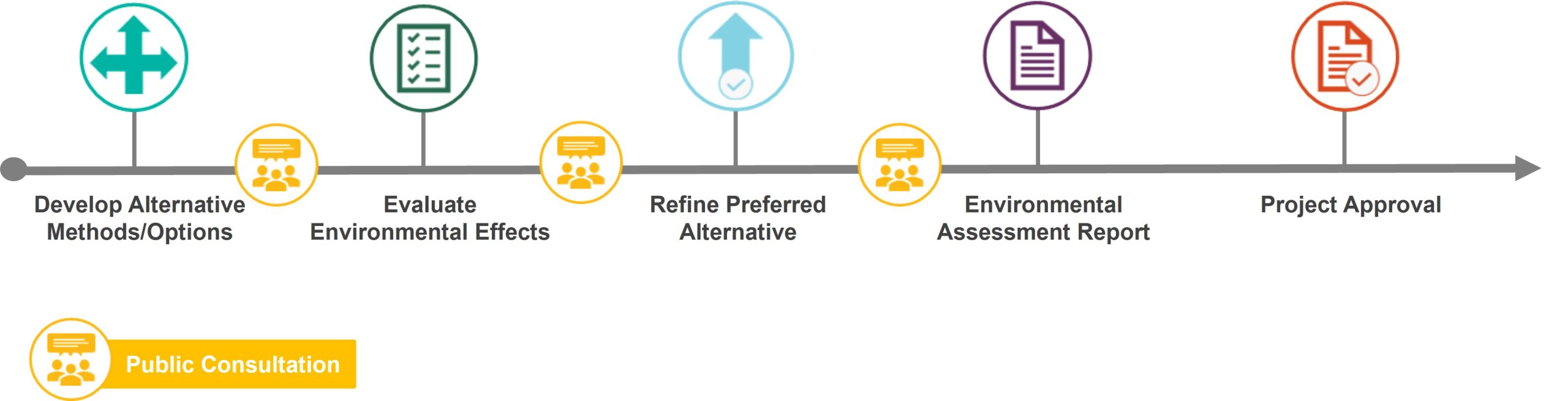
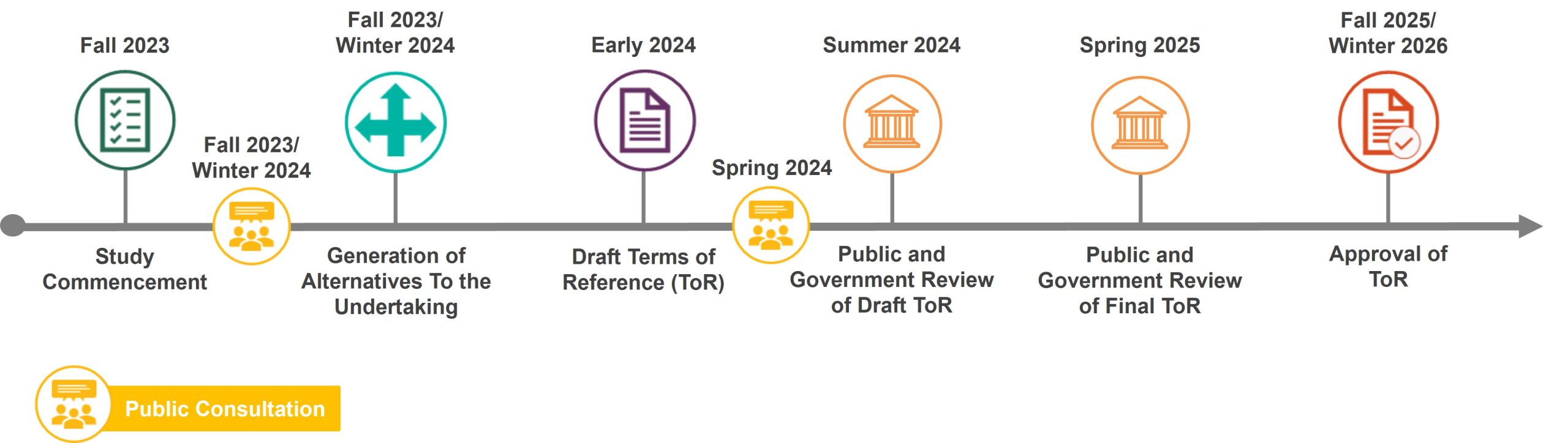
The Scarborough Bluffs West Project was initiated as an Individual Environmental Assessment (now known as a Comprehensive EA) in the Fall of 2023. The process includes the following steps:
*Voluntary Agreement
In 2024, the Province changed legislation replacing Individual Environmental Assessments with the new Comprehensive Environmental Assessment framework requiring waterfront projects to meet a certain threshold of impact (1km of shoreline alteration and 4 hectares of lakefill). Following Toronto and Region Conservation Authority’s confirmation that it is unknown at this time whether those new thresholds will be met, as alternatives are not developed at the Terms of Reference stage, the Ministry of Environment, Conservation and Parks advised TRCA that the only way for the Scarborough Bluffs West Environmental Assessment to proceed as a Comprehensive Environmental Assessment was through the signing of a Voluntary Agreement to undertake a Comprehensive Environmental Assessment. In April 2025, the Ministry of Environment, Conservation and Parks sent Toronto and Region Conservation Authority a copy of the Voluntary Agreement for the City and Toronto and Region Conservation Authority to sign as co-proponents. A Member’s Motion put forward at City Council in April, which was then deferred to and approved at City Council in May (2025.DM30.1). The Member’s Motion was an administrative step to authorize the City to enter into the Voluntary Agreement with Toronto and Region Conservation Authority and the Ministry of Environment, Conservation and Parks. This step was needed so the Comprehensive Environmental Assessment process can move ahead, as originally approved by City Council in 2021.
Objectives will provide a basis for evaluating the alternatives later in the Environmental Assessment process. Draft objectives include:
Evaluation criteria measure the ability of each alternative to meet the project objectives and will be used in the Environmental Assessment to assess effects and select a preferred alternative. Draft criteria include:
In the third round of public consultation, we asked for your feedback on the proposed alternatives and how they will be evaluated.
A Public Drop-In Event was held on June 1, 2026 that included project information panels with an opportunity to speak with members of the project team one-on-one. View the information panels below.
Part 1: Project Background, Alternatives Development Process and Next Steps
Part 2: Evaluation Criteria
Part 3: Segment 1A – Site Opportunities and Alternatives
Part 4: Segment 1B – Site Opportunities and Alternatives
Part 5: Segment 2 – Site Opportunities and Alternatives
Part 6: Segment 3 – Site Opportunities and Alternatives
Part 7: Segment 4 – Site Opportunities and Alternatives
The second round of public consultation about the draft Terms of Reference was held from May 14 to June 11, 2024.
A summary report of what we heard in Round Two is now available.
The first round of public consultation about the draft Terms of Reference was held from January 31 to February 28, 2024.
A summary report of what we heard in Round One is now available.
A Community Advisory Group (CAG) has been established to provide advice to the project team throughout the study. The CAG is made up of representatives of organizations with an interest in the study and/or who represent residents of Scarborough. The CAG will meet five times throughout the project to review materials and provide input. Minutes will be posted publicly following each meeting.
Meeting #1 Summary (January 11, 2024)
Meeting #2 Summary (April 30, 2024)
The project study area is located on the traditional territory of many nations including the Anishnabeg, Haudenosaunee and Wendat peoples and is now home to many diverse First Nations, Inuit and Métis peoples. Archaeological evidence from this area shows that people were living and hunting along the Scarborough Bluffs at least as early as 10,000 years ago.
Engagement with urban Indigenous community members as well as treaty and territorial partners with an interest in the project was conducted in April and May 2024. Ongoing engagement will take place over the length of the project to ensure that Indigenous knowledge and priorities are incorporated into the final Environmental Assessment. A summary of what has been heard to date can be found in the Consultation Record for the Terms of Reference.
TRCA, in partnership with the City, initiated the study following direction from Toronto City Council in 2021 (2021.EX28.6), which highlighted Scarborough Bluffs West as a priority project to address remaining risks to public safety and property and explore the viability of a waterfront trail connection.
The City and TRCA are undertaking a Comprehensive Environmental Assessment (formerly named ‘Individual Environmental Assessment’) which involves two phases, and includes significant technical and consultation work. It also includes a full provincial government review of the Terms of Reference (Phase 1) for approximately six months and of the Environmental Assessment document (Phase 2) for approximately 12 months. Comprehensive Environmental Assessments typically take about five years to prepare and approve.
Phase 1 was completed in Fall 2025, receiving approval from the Ministry of Environment, Conservation and Parks on October 1, 2025. Disposition tables with responses to all comments received during the review period, which were considered as part of the Ministry review process, are available in the ‘Terms of Reference’ section of the project webpage.
The City and TRCA are completing a ‘focused’ Environmental Assessment, in accordance with Section 17.4(1) of the Environmental Assessment Act.
The need and justification for the Scarborough Bluffs West Project has been established through a number of previous policies and planning studies, along with the existing policies in the City of Toronto’s Official Plan and Toronto and Region Conservation Authority’s The Living City Policies that further reinforce the need for a holistic solution to address the issues of access, improved experience, erosion, and habitat improvements.
The list of studies in Table 2-1 of the Terms of Reference also includes several recent studies that have reaffirmed the goals of equitable access, improved experience, habitat improvement, reconciliation, and management of erosion risk. Further, City Council reaffirmed many of these goals in the 2022 Update on the Next Phase of Waterfront Revitalization.
These studies and plans identify the need for integrating improved public access with erosion protection works and habitat improvements along the section of the Scarborough waterfront between the Eastern Beaches in the west and Bluffer’s Park in the east. As has been discussed on several occasions, none of the documents in Table 2-1 suggest the Alternative Methods to be considered as part of this Environmental Assessment; the Alternative Methods will not be developed until the Environmental Assessment phase.
TRCA received approximately $2.9 million from the City of Toronto to conduct the Environmental Assessment. At this time, there is no funding secured for the design or construction of the future preferred option that will be selected through the Environmental Assessment process.
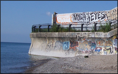
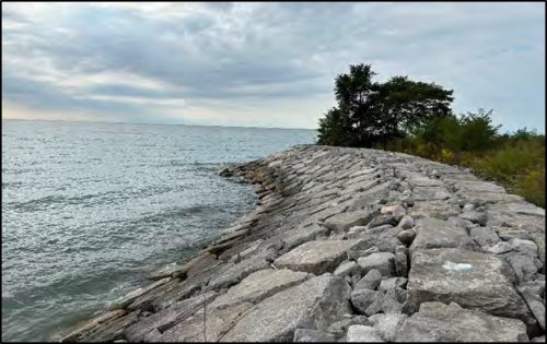
The study area has been impacted by past and on-going human use. Currently, people are accessing the shoreline via informal paths and makeshift trails, which impacts the natural environment. The Environmental Assessment will explore opportunities to formalize the trail network along the waterfront thus minimizing the impact of unmanaged use. Most of the shoreline in this area has already been modified through existing erosion management structures.
The project study area has been divided into four proposed shoreline segments, recognizing the distinct characteristics along the waterfront. The project may recommend some combination of the following elements, within all segments of the project study area at the top and/or toe of the bluffs:
The project will explore opportunities to create a trail alignment that will establish a connection between the Martin Goodman Trail at Eastern Beaches and Bluffer’s Park, and provide greater access to and along the waterfront.
The project will explore the feasibility of implementing a shared, multi-use trail that meets the standards of the City of Toronto Multi-use Trail Guidelines (2015) to support pedestrian and cyclist use. The multi-use trail is not a roadway. Depending on site constraints, the trail may be a paved, at-grade facility or take the form of an elevated boardwalk. There is no proposal yet for the type of trail or alignment of the trail. A number of options will be explored based on site constraints and impacts, including continuous shoreline trails, top of bluff alignments, and a combination of both.
Conceptual alternatives have now been released to the public as part of the first round of engagement for the Environmental Assessment Phase.
Note that Environmental Assessments do not involve development of detailed designs. Following completion of the Environmental Assessment and approval by the Province, TRCA would seek funding to undertake detailed design work of the preferred alternative. The City is also in ongoing discussions with the provincial and federal governments about potential funding for the next phase of waterfront revitalization.
For waterfront projects, traffic impact studies are typically undertaken for construction traffic and such a study will be completed for this project. Traffic impact studies for the day-to-day operation of a waterfront area are typically not undertaken as part of waterfront Environmental Assessments as it is difficult to accurately estimate the number of visitors that may access the waterfront in the future, how they will access it, and how long they will stay.
Concerns heard from residents to date about traffic impacts have been mostly related to parking on residential streets. Parking is an issue at other waterfront sites and the City of Toronto has developed a number of approaches to manage parking impacts on residential streets.
As part of the identification and evaluation of alternatives, the project team will be seeking to identify connections with transit and active transportation, while also establishing new access points where feasible and appropriate.
Park maintenance and operations concerns are not within the scope of this study. The City is responsible for maintaining the parks and beach areas within the study area. There is a periodic maintenance schedule for garbage clean-up. However, access to the shoreline for garbage clean-up by City staff is limited. To file a maintenance or enforcement request, please create a service request through 311.
Erosion refers to the loss of material (soil, rock, etc.) due to wind, water, or other processes. Throughout the study, reference will be made to existing erosion protection structures already in place to help manage shoreline erosion along the Scarborough Bluffs West area. TRCA is responsible for the installation and maintenance of these structures. Future improvements or additions to these structures are part of what will be explored in the Environmental Assessment.
A seawall is a concrete or steel sheet pile structure built parallel to the shore, to protect inland areas against wave action and prevent coastal erosion.
Sheet pile is metal or vinyl sheets that use interlocking edges to create a continuous wall.
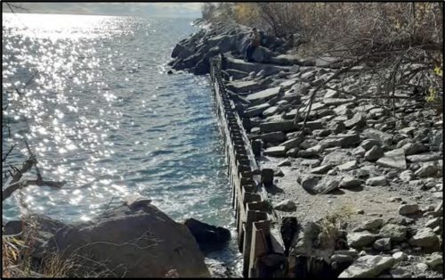
A revetment is a sloped or unsloped structure, made of an impact resistant material (e.g. armourstone) to protect a bank or shoreline. Armourstone is broken quarried rock often used in coastal engineering.
A groyne is a low wall of armourstone or other material that is built out into a waterbody to stop drifting and erosion of sand and sediment. A series of groynes act together to create and protect beaches.
Backshore Erosion: Erosion behind a coastal wall from wave overwash (waves higher than the top of the wall that damage the soil behind)
Mass Failure: When a large piece of bank collapses due to erosion processes
Bluff: A steep bank created by erosion processes, usually along a shoreline
Littoral Zone: The area close to shore that is sometimes or always covered in water depending on tidal activity
TRCA defines a dynamic beach hazard as areas of inherently unstable accumulations of shoreline sediments along Lake Ontario, as identified by provincial standards (TRCA, 2025).
In practice, beaches that are integral parts of shoreline erosion protection works are not considered dynamic beaches.
Apart from the western-most edge of Bluffer’s Park, the sand and/or cobble headland-beaches that exist within the project study area are engineered together with the groynes (beach and groyne system) to form works that protect the shoreline and bluffs. As a result, these are not considered to be dynamic beaches.
The alternatives developed by the project team preserve the existing off-leash dog area use.
For more information on the City’s updated Off-Leash Policy, check out On April 23 and 24, 2025, City Council adopted Item IE20.9 - Toronto's Dog Off-Leash Strategy: A Citywide Approach to Dogs Off-Leash Areas.
A Terrestrial Biological Inventory was undertaken by TRCA in 2016 to characterize the existing terrestrial conditions of the project study area. The inventory identifies what plants and animals are found in the natural areas of the project study area between Bluffer’s Park and R.C. Harris. It considers only the terrestrial ecological components of the environment, and is updated every 10 years for fauna data and every 15 years for flora and Ecological Land Classification data, as per TRCA’s best practices. The current results are available in TRCA’s 2017 Terrestrial Biological Inventory report and are summarized in Section 5.2 (Description of the Natural Environment) of the Terms of Reference. This information will also help inform the future Environmental Assessment phase (pending Ministry approval of the Terms of Reference).
Climate change is an important aspect of project planning, and we are required to look at both the impact of climate change on the project, as well as potential impact of the project on climate change as part of the Environmental Assessment. A number of technical studies will ensure that the project is designed to be resilient to climate change over the long-term.
The Scarborough Bluffs West project builds off objectives identified in the Scarborough Waterfront Project (SWP) and will explore opportunities to connect to planned trails in the area.
The detailed design of the SWP West Segment shoreline (from Bluffer’s Park to Meadowcliffe) and Brimley Road South Multi-use Trail is complete. Funding to advance implementation of the Brimley Road South Multi-use Trail is secured, and construction is slated to begin this fall. You can get the latest updates on the SWP by visiting TRCA’s website.
The Scarborough Bluffs West Study is a separate Comprehensive Environmental Assessment process from the previously approved Scarborough Waterfront Project.
These projects are differentiated due to the complexity of and variability in the shoreline and community conditions between two project Study Areas. Cumulative effects of the Preferred Alternative were assessed as part of the Scarborough Waterfront Project Environmental Assessment. The same will be done for the Scarborough Bluffs West Project during the Environmental Assessment.
As the first step in the Scarborough Bluffs West Project, a Terms of Reference was submitted to the Ministry of the Environment, Conservation and Parks for review as required under the Environmental Assessment Act.
The City of Toronto, in partnership with Toronto and Region Conservation Authority, is undertaking the Scarborough Bluffs West Project, which will explore the enhancement and protection of sensitive shoreline and natural areas, in addition to opportunities for improved waterfront experiences and access to and along the shoreline between the Eastern Beaches (Silver Birch Avenue) and Bluffer’s Park along Lake Ontario.
The Terms of Reference will serve as a framework to begin future phases of the Environmental Assessment study, including review and evaluation of opportunities to:
This may involve some combination of the following, within all segments of the Project Study Area at the top and/or toe of the bluffs:
The Project team will also consider the option to “Do Nothing” through each stage of the Project.
While we aim to provide fully accessible content, there is no text alternative available for some of the content on this page. If you require alternate formats or need assistance understanding our maps, drawings or any other content, please contact us at 416-338-2850 or email Maogosha.Pyjor@toronto.ca.