Cycling activity was measured at both intersections and mid-block locations by third party vendors specializing in traffic data collection. Data was collected using videos and sensors. The vendors must complete quality control of the data through accuracy checks and testing. City staff also conducted periodic checks to ensure reliable and accurate data.
To achieve project goals and limit impacts, the project team studied traffic and consulted with representatives of emergency services, businesses and Business Improvement Areas (BIAs).
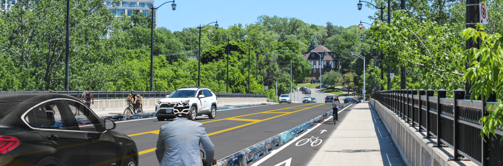
Safety measures for all road users included new crosswalks, cycle tracks separated by concrete curbs, bollards and planters, centre-left turn lanes, painted curb extensions, raised bus platforms and new signage. Right-turn-on-red (RTOR) prohibitions were also implemented at select signalized intersections along the corridor with a documented history of collisions to improve safety for pedestrians crossing the intersection and to reduce conflicts between people driving and cycling.
More safety measures were implemented in 2024-2025, including giving dedicated traffic signal time to different modes, and enhancing the visibility of pedestrians and people cycling to turning drivers by changing the radius of curbs and adding turn-calming features.
At many intersections along the corridor, painted curb extensions were added to reduce exposure of vulnerable road users in the intersection and to slow the speed of turning drivers. Some are painted to indicate this is pedestrian space and not typical roadway, and for placemaking purposes. The geometry of these extensions follows the City’s Curb Extension Guidelines. Some of the locations are candidates for permanent curb extensions, which can be constructed as part of upcoming civil works or future planned capital work along the corridor.
Transportation Services did not conduct a cost-benefit analysis and does not typically conduct this type of study for similar projects. Rather, City Council provided direction to implement new bikeways in order to achieve the goals within the Vision Zero Road Safety Plan – with a goal to eliminate serious injury and death, and TransformTO: Toronto Climate Action Strategy – which target’s 75% of all trips under 5 km to be on foot, bike or transit by 2030.
City Council approved the project as part of its June 2023 meeting. The installation of Phase 1 of the Bloor West Complete Street Extension was awarded through the City of Toronto’s Bid Award Panel on July 26, 2023, to the lowest bidder on a Request for Quotation basis. The process followed all Council-approved procurement and cost-control bylaws and policies.
Bloor Street West between Runnymede Road and Resurrection Road was prioritized in the Cycling Network Plan’s Near-Term Implementation program (2022-2024) endorsed by City Council in December 2021. Bloor Street West is one of the City’s Major City-Wide Cycling Routes. Please see the prioritization framework and maps of prioritization considerations.
Motor vehicle trips are the greatest local source of air pollution emitted in Toronto. Research conducted for the TransformTO Net Zero Strategy states that traffic-related air pollution and its health effects will be improved with increased active transportation infrastructure and transit ridership.
Accessibility is a priority in all street design. The Bloor Street West Complete Street Extension prioritized accessibility through Accessibility for Ontarians with Disabilities Act upgrades and improvements at intersections, new dedicated accessible loading zones and raised platforms to service Wheel-Trans and accessible taxis, and new or maintained accessible parking spaces. The addition of cycling infrastructure also makes the street safer for people cycling who have a disability by providing a protected space separate from motor vehicle traffic, as well as keeping people cycling from using the sidewalk and conflicting with pedestrians.
The project design follows the City’s Lane Width Guidelines and On-Street Bikeway Design Guidelines in the determination of lane widths. General design practices within the City of Toronto and elsewhere aim to reduce lane widths to promote slower vehicle speeds. Lane widths for active transportation users are, in comparison, preferred to be wide enough to support snow clearing, provide opportunities to pass safely within the lane and to give additional operating space for people cycling to avoid hazards such as potholes and debris.
Enforcement is the responsibility of the Toronto Police Service and parking enforcement officers. Concerns around behaviour of road users should be brought to their attention.
You can request enforcement by the Toronto Police Services (TPS) via their Citizen Online Report Entry (CORE).
In addition, you can reach the police non-emergency line at 416-808-2222, which allows residents to connect with police services, personnel and programs. Toronto Police Service will take all reports of crime over the non-emergency line, however, they do encourage everyone to use the online reporting services for convenience.
Requests for parking enforcement can be submitted to the Toronto Police Services online via their website.
The north side of Bloor Street West between Armadale Avenue and Jane Street is critical to TTC operations. Three regular service routes and one express service route occupy this space during the daytime. It is common that the TTC runs more than 20 buses per hour in the peak periods from 6-9 a.m. and 4-7 p.m. Operating buses in mixed traffic would reduce the TTC’s ability to move tens of thousands of customers per day. This design reduced the ability of businesses on the block to accept and make deliveries adjacent to their properties. There is loading space across the street, as well as on the north side east of Armadale Avenue, which can be used as an alternate location for deliveries and other commercial loading. Passengers being picked up or dropped off can do so from the “No Standing” zones on Armadale Avenue (east side, north of Bloor Street West) and Jane Street (eastside, north of Bloor Street West).
Changes to Bloor Street West included materials that were installed quickly, such as bollards, roadway paint, planters and signage. No major road reconstruction is planned.
Phase 1, Runnymede Road to Aberfoyle Crescent, was installed in 2023.
Phase 2, Aberfoyle Crescent to Resurrection Road, was installed in June 2024.
Other updates included:
Further upgrades are planned, including pedestrian safety improvements at select intersections, a new sidewalk along the Park Lawn Cemetery and additional traffic signal improvements to add bicycle signals and make changes to phasing to improve safety for all roadway users.
The following documents are roll plans for the project. The legend for the roll plans can be found below.
Please note that the roll plans are large files and may take time to load. In addition, the roll plans are not accessibility compliant – if you require assistance please contact us.
Legend: 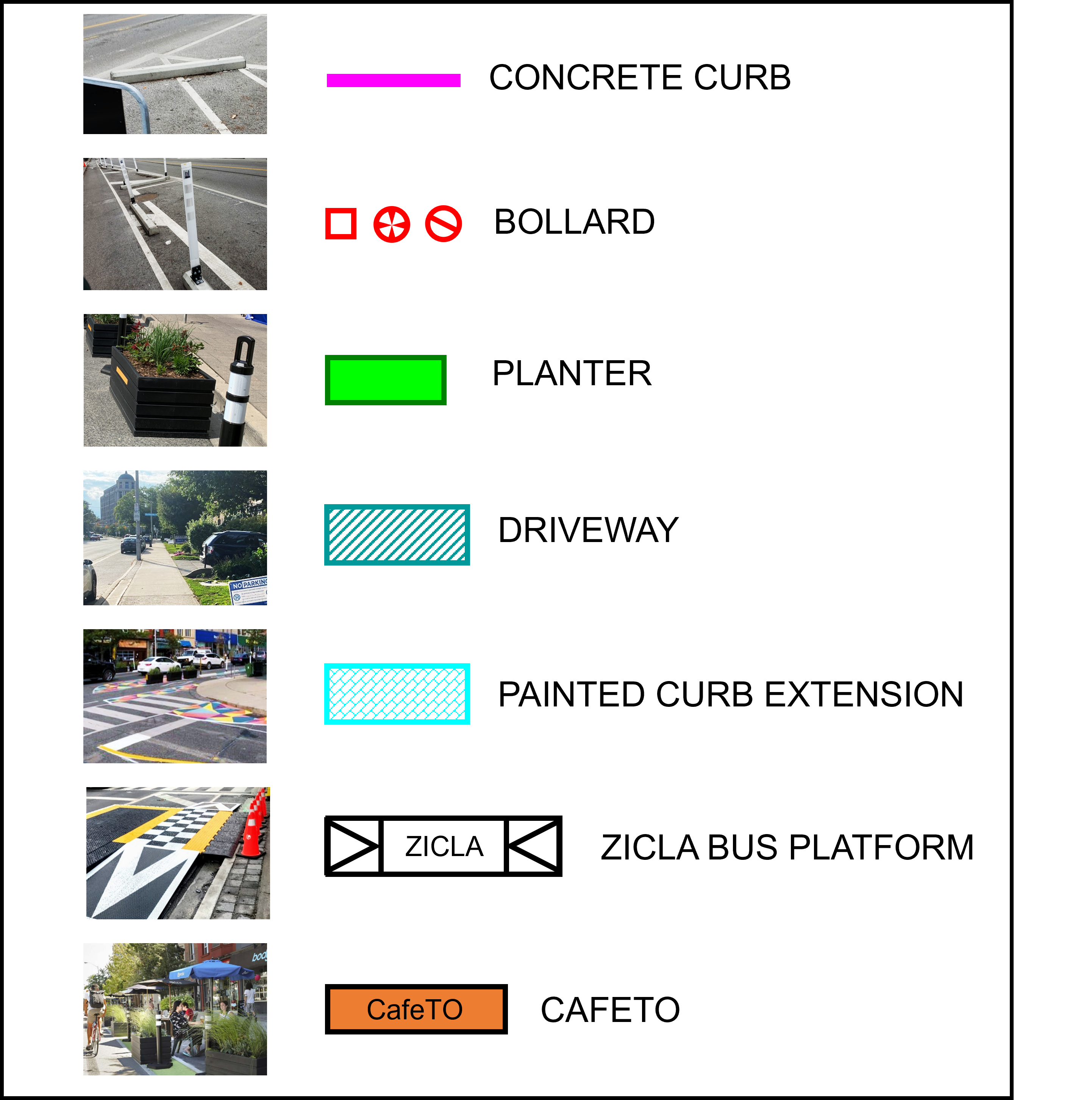
The project team reviewed potential locations for new commercial and accessible loading zones in consultation with Business Improvements Areas and Wheel-Trans, and informed by pick-up/drop-off demand data along the corridor, Wheel-Trans guidelines and Complete Streets Guidelines. The table below summarizes the locations of both existing and new accessible and commercial loading zones on Bloor Street West.
| Location on Bloor Street West | Loading Zone Type | New or Existing Loading Zone |
| North Side (Westbound) | ||
| Midblock between Avenue Beresford and Runnymede Road | Accessible | New |
| Midblock between Willard Avenue and Windermere Avenue | Commercial | New |
| West of Willard Avenue | Accessible | New |
| West of Royal York Road | Commercial | New |
| South Side (Eastbound) | ||
| East of Cosmo Road | Accessible | Existing |
| West of Elsfield Road | Accessible | New (previously signed for accessible parking) |
| ~60 m east of Riverside Drive South | Accessible | New |
| Midblock between Jane Street and Armadale Avenue | Accessible | New |
| Midblock between Willard Avenue and Windermere Avenue | Commercial | New |
| Midblock between Windermere Avenue and Durie Street North | Accessible + Commercial | New |
The following stop modifications were identified alongside TTC stakeholders, with consideration for the TTC surface stop spacing guidelines.
TTC bus routes 66 – Prince Edward and 300 – Bloor-Danforth Night Bus will be impacted by these changes.
The table below summarizes changes, including the removal of, relocation of, shifting of, or new stops, made to TTC bus stops along this section of Bloor Street West. All other stop locations will be maintained.
TTC Bus Stop Modifications:
| Stop Location on Bloor Street West | New or Existing Stop | Updates |
| Westbound | ||
| Jackson Avenue | Existing | Removed |
| Kingsmill Drive | Existing | Relocated to west of The Kingsway |
| Old Mill Road | Existing | Relocated to west of The Kingsway |
| Riverside Drive | Existing | Relocated to new stop at Traymore Crescent |
| Traymore Crescent | NEW | New stop |
| 2500 Bloor Street West | Existing | Relocated to new stop at Traymore Crescent |
| Eastbound | ||
| Grenview Boulevard | Existing | Removed |
| Kingscourt Drive | Existing | Removed |
| Old Mill Trail | Existing | Shifted 20m to the west |
| Riverside Drive | Existing | Relocated to new stop at Brule Terrace |
| Brule Terrace | NEW | New stop |
| Mossom Road | Existing | Shifted 20m to the east |
Within the first year following installation of this project, the City:
In June 2024, Transportation Services published an Interim Condition Data Update, which included preliminary data collected after many of the pavement markings, signage and accessible platforms had been installed but before the completion of all the complete street elements, including some painted curb extensions, physical separation and signal adjustments.
The Interim Condition Data Update has been revised to include information from Toronto Fire Services and Toronto Paramedic Services on emergency response times.
Toronto Fire Services ran an analysis of a 500m buffer around Bloor Street West from Aberfoyle Crescent to Runnymede Road to assess travel times for emergency response. Toronto Fire Services examined response times from before the installation (2022), during construction (July – September 2023), and post installation (October – December 2023).
For the period of July to September 2023, the 90th percentile travel time for the first arriving truck at an incident decreased 13 seconds compared to the same time period in 2022, while city wide it increased by 4 seconds. For the period of October to December, the 90th percentile travel time for the first arriving truck at an incident increased 30 seconds compared to the same time period in 2022, while city-wide it increased by 2 seconds.
As the sample size of events available for this evaluation was small, the data may be subject to limitations and a higher variability in the results.
Toronto Paramedic Services conducted an analysis of a 500m buffer around Bloor Street West from Aberfoyle Crescent to Runnymede Road to assess travel times for TPS emergency response. Toronto Paramedic Services examined response times for the periods provided by Transportation Services before install period July 10, 2023 to September 10, 2023 and after install period of October 10, 2023 to December 10, 2023.
For the period of July 10 2023 to September 10, 2023, in the 500m buffer an average response time of 08:29 and the City-Wide average was 09:11. For the period of October 10, 2023 to December 10, 2023, in the 500m buffer an average response time of 9:11 and the City-Wide average of 09:56. This was an in increase of 0:42 and 0:45 respectively.
Toronto Paramedic Services average of over 320,000 calls annually. The data reviewed was for a very small sample size and may not accurately reflect impacts on response times.
The traffic study summarizes the vehicular traffic analysis. Traffic analysis is only one type of analysis that informs the design of complete street projects. Complete street projects aim to balance the needs of different types of road users and to promote the safety of vulnerable road users, including people cycling and pedestrians.
The purpose of the traffic study was to:
Major considerations in the traffic study include:
Transportation Services consulted with local residents and businesses between January and May 2023 to identify overall needs and priorities, before completing the design and implementing the project. Below is a summary of consultation and communication activities during that period.
Additional details about consultation activities as well as a summary of feedback received can be found in the Consultation Report. Overall, consultation activities saw a contrast between participants who supported a complete streets design and the proposed bikeways, and participants who had concerns about traffic congestion and impacts.
The June 2023 Project Update summarized comments received through the consultation and incorporated into the final proposal presented to Infrastructure and Environment Committee and City Council. Most notably, the project team addressed feedback related to increasing the number of right-turn-on-red restrictions; installing a physical barrier at Mossom Road; extending the westbound right-turn lane at Old Mill Road; accommodating loading space at Royal York Road and Bloor Street West; and adding a right-turn arrow at Thompson Avenue.
Consultation Materials
Roll Plans
Please note that the roll plans are large files and may take time to load. In addition, the roll plans are not accessibility compliant – if you require assistance please contact us.
In addition to the consultation efforts lead by the project team, Councillor Amber Morley (Ward Etobicoke-Lakeshore) has organized additional opportunities to share project information with the public, including virtual events.
The City recognizes that spaces for loading and deliveries are critical for the operation of businesses and organizations. To help inform the design of the project, the City engaged with businesses and property owners to understand loading demands and requirements along Bloor Street West within the project area (Runnymede Road to Resurrection Road) through a Business Delivery Survey.
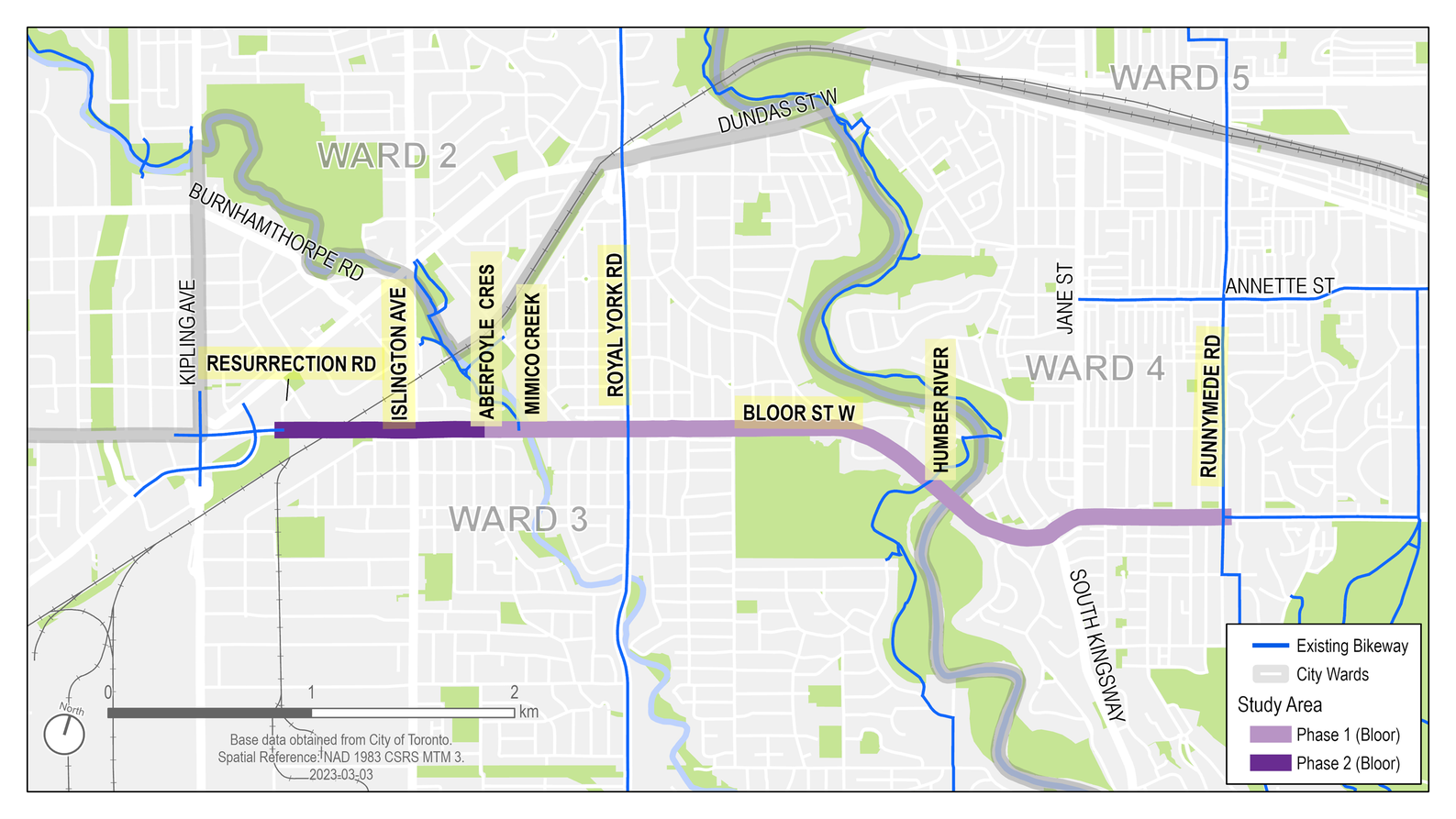
Map of Bloor Street West Complete Street Extension project corridor. Phase 1 from Runnymede Road to Aberfoyle Crescent was substantially completed in December 2023, while Phase 2 from Aberfoyle Crescent to Resurrection Road was substantially completed in June 2024.
The following road safety improvements and complete street elements were installed along Bloor Street West from Runnymede Road to Aberfoyle Crescent as part of Phase 1.
The intersection of Bloor Street West, South Kingsway, Riverview Gardens and Mossom Road was reviewed for ways to improve safety and optimize traffic flow. Phase 1, including the following intersection improvements was installed in 2023 to increase safety:
The following road safety improvements and complete street elements were installed along Bloor Street West from Aberfoyle Crescent to Resurrection Road as part of Phase 2.
Since the start of installation in September 2023, the City has monitored public feedback on potential changes to the design and installation. This feedback was reviewed, compared with technical considerations, and included site observation before changes were made. The following changes have been implemented since installation:
Following the public consultation in winter 2023, the project team reviewed comments and identified actionable comments that could be incorporated into design or operational changes for this project. The June 2023 Project Update provides a summary of comments that were incorporated and information on the changes from what was previously been presented.
Since 2016, protected bikeways have been installed in phases along Bloor St. In 2016, the Bloor Bike Lanes were installed as a pilot project from Avenue Road to Shaw Street. Following an evaluation of the pilot project, City Council approved a permanent installation of the cycle tracks in 2017. In fall 2019, the City carried out consultation on the Bloor West Bikeway Extension from Shaw Street to Runnymede Avenue. Cycle tracks were installed on this segment of Bloor Street West in 2020 and 2021.
The current Cycling Network Near-Term Implementation Program was adopted for 2022-2024, which includes The Bloor St W Complete Street Extension.
To receive updates by email, subscribe to the project email list.