The City of Toronto is examining options to redesign the intersection of Eglinton Avenue West and the Allen Road Expressway. This study will explore ways to improve traffic congestion both at the intersection and in surrounding neighbourhoods.
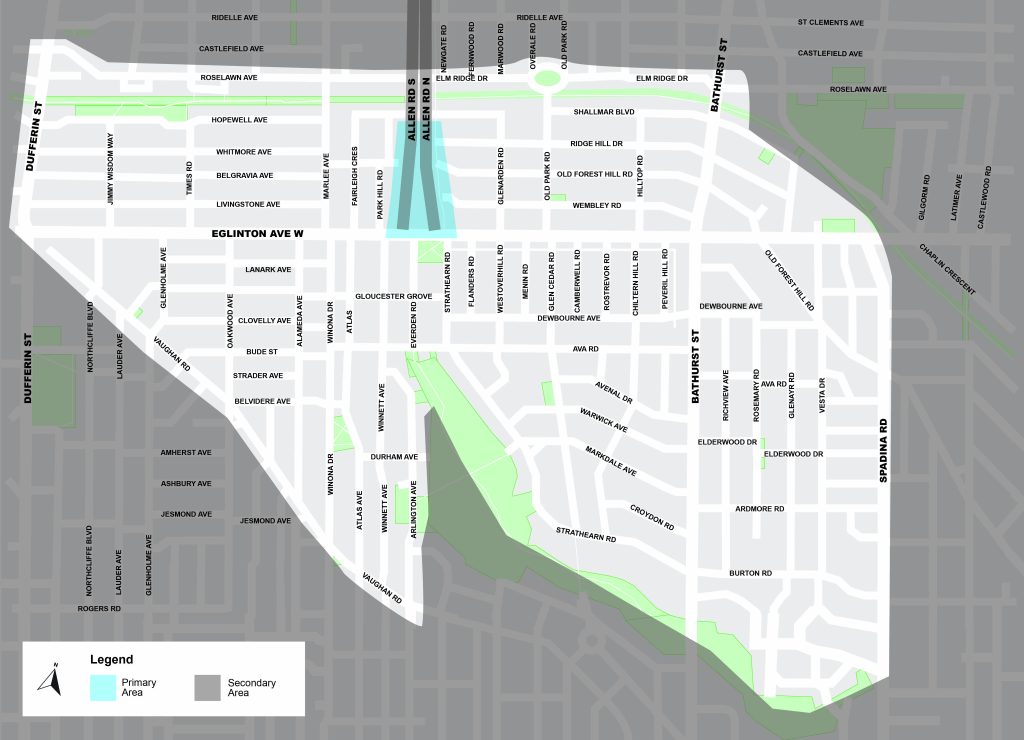
Primary Area (Intersection Redesign): Eglinton Avenue West and Allen Road intersection, extending 400 metres north along the Allen Road ramps
Secondary Area (Mobility Strategy): Analyzed for traffic patterns and opportunities to implement neighbourhood mobility strategies
The Allen Road Expressway was first planned as part of the Spadina Expressway to connect the north end of Toronto to downtown. The project was cancelled in 1971 after strong public opposition, so Allen Road now ends at Eglinton Avenue West, a major city street.
The City was directed to undertake an Individual Environmental Assessment study in 2010 to address the state-of-good-repair, transportation function and urban design for Allen Road. The study Terms of Reference was completed in 2014 but was not advanced due to provincial concerns that the alternatives were too broad to be implemented without further land use planning, as well as the need for critical investments in infrastructure elsewhere in the city ( 2016.PW14.8 ). An initial review has been done of the previous study work to determine what can be carried forward to be considered as part of the Eglinton & Allen Intersection Study.
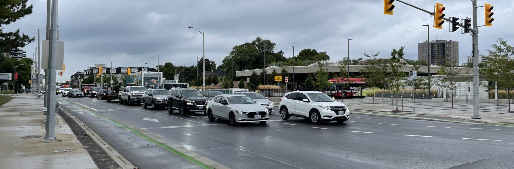
Before 2014, the intersection of Eglinton Avenue West and Allen Road had a three-lane northbound on-ramp. From 2014 to early 2023, the intersection had long-term lane closures because of construction for the Eglinton Crosstown LRT (ECLRT). In May 2023, Metrolinx reopened the intersection with a new design. It now has alternating dual eastbound left-turn lanes and dual westbound right-turn lanes, plus pedestrian crosswalks on the north and east sides.
Since reopening, the City has taken back jurisdiction of the intersection and made changes to signal timing and other operations to address traffic congestion. Even with these improvements, traffic problems remain. Congestion on Eglinton Avenue West and nearby streets has slowed travel times, and more drivers are using local streets to attempt to avoid delays.
In 2024, the City looked at short-term options to improve the intersection. The fastest changes have already been made. Medium-scale changes, like moving crosswalks, were assessed as not providing enough benefit to justify implementation.
The opening of the new Cedarvale ECLRT station has provided another way for pedestrians to access the station and to cross Allen Road, however, the tunnel is only open when transit is running. In February 2025, City Council asked staff to study long-term redesign options to improve traffic. This includes looking at a pedestrian tunnel or bridge, widening the northbound Allen Road on-ramp, and other physical changes (2025.MM26.12). Council also asked staff to keep working with the community to find short-term ways to reduce congestion while the study continues.
Potential improvements to the intersection include modifications to cycling and pedestrian crossings and redesign of the roadway, intersection and ramps.
Review the project materials (updated May 28), including diagrams on pages 18-33.
Public Consultation will take place in two phases. Phase One consultation took place in Spring 2026, and sought feedback on a long list of potential improvements to the intersection. A summary of comments received during this consultation will be shared on this page later in the summer.
Phase Two will seek feedback on a short list of proposed options and a preferred option.
Two Public Drop-In Events were held on May 30 and June 2, 2026, that included an opportunity to speak with project staff and view display boards. View the display boards.
The online survey asked for input on study priorities and the long list of proposed improvements to the intersection. The online survey is now closed.
Participants were invited to leave feedback on an interactive map to help identify areas of concern and potential improvements related to traffic and road safety in the area. The map is now closed, but the submissions can be viewed here.
An update on the trial traffic changes and the Eglinton & Allen Study was presented at a virtual community meeting on March 23, 2026.
A survey to collect resident input on a trial of traffic pattern changes for neighbourhoods around Eglinton Avenue West and Allen Road was open from January 19 to February 8, 2026. A Public Consultation Report is available.
A drop-in and in-person workshop was held on May 26, 2025 for neighbours and traffic experts to discuss options to mitigate traffic infiltration on neighbourhood streets around the Eglinton Avenue West/Allen Road intersection.
A Virtual Public Meeting was held on May 13, 2025, that included a presentation and Question & Answer period. View the presentation and recording below.
Consultation Report
The City has heard from residents about the need for urgent, near-term action to address the ongoing impact of traffic congestion caused by vehicles accessing the Eglinton Avenue West and Allen Road intersection from neighbourhood streets.
Following community input through consultations, the City conducted a trial of traffic pattern changes from December 2025 to February 2026, which included turn restrictions and ‘Do Not Enter’ regulations for the following intersections:
See Item - 2025.IE25.6 for details of the traffic changes made.
These changes were intended to help keep Allen Road-bound traffic on main streets (Spadina Road, Bathurst Street and Eglinton Avenue West), and address traffic congestion on neighbourhood streets around the Eglinton Avenue West and Allen Road intersection.
During the trial, traffic counts showed that the changes were effective, with an overall reduction of volumes on local and collector roads. However, many participants in the survey reported dissatisfaction with the trial, primarily due to increased travel times for local residents to get to and from homes. Following the monitoring, Council approved an amendment at the March 26-27, 2026 meeting to rescind the left turn and no-through restrictions at Bathurst Street and Strathearn Road. The remainder of the changes remain in place.
Review the full results:
Future changes to traffic patterns in the area to address ongoing congestion are expected to be addressed through the Eglinton & Allen Intersection Study Neighbourhood Mobility Strategy.
Over the last few years, the City has taken steps to address congestion issues at this intersection:
Prior to the beginning of construction on the Eglinton Crosstown LRT (ECLRT) in 2014, the northbound on-ramp to Allen Road operated as a three-lane ramp, with two westbound right-turn lanes and one eastbound left-turn lane. The intersection was redesigned during ELCRT construction and re-opened in 2023 in a two-lane design with alternating dual eastbound left-turn and dual westbound right-turn lanes with a new pedestrian north-south crosswalk. This design was selected to address concerns about eastbound capacity at the on-ramp intersection and to provide safer pedestrian and cycling infrastructure. The analysis of this design assumed that pedestrian demand to cross the Allen Road expressway would be mitigated by the opening of the Eglinton Cedarvale station entrances, but this opening was delayed until late 2025.
A four-lane design for the intersection was considered and studied prior to the re-opening, but was determined to be prohibitive due to complications in grading and would have required property acquisitions on the east side of the ramp. However, the current study will examine potential alternative configurations of a four-lane on-ramp.
The study will include an examination of feasible options to improve the functionality of the intersection. This could include a pedestrian bridge or tunnel, expanding the mouth of the Allen Road expressway on-ramp, and any other physical modifications to the intersection to improve traffic operations. The study will also examine short-term improvements to improve congestion in the neighbourhood while the study is underway.
The majority of the traffic at the Eglinton/Allen intersection is generated by travel to and from Allen Road, which the opening of the ECLRT itself will not eliminate. But it is anticipated that the opening of the new Cedarvale ECLRT station on November 16, which will include entrances on the east and west sides of Allen Road, will minimize pedestrian demand to cross the on and off ramps. Additionally, the opening of the ECLRT will reduce the demand for bus service along Eglinton Avenue, particularly for the 32 Eglinton West bus which currently operates at a frequency of every three to five minutes at peak times. The opening of the ECLRT can also reduce congestion as travel shifts from driving to transit use.
Traffic agents have been deployed to the Eglinton/Allen area as resources and emergency needs permit to support enforcement. As the Eglinton/Allen traffic signals alternate between double eastbound and double westbound turns, pausing only for pedestrian demand, there is little time for agents to over-ride the signals to improve traffic flow. Agents have also been positioning themselves throughout the Eglinton / Allen area as needed, often helping cars exit side streets onto Eglinton Avenue to help ease neighbourhood congestion.
Many residents have requested better enforcement of existing restrictions before introducing new ones. While enforcement does have a temporary benefit, the Toronto Police Service is constrained how often and in how many locations officers can be stationed. The restrictions that have the highest degree of compliance are full day (as opposed to peak hour-only) turn restrictions, as well as the introduction of short segments of one-way streets. Peak hour-only restrictions are not recognized by navigation apps or drivers, therefore have very low compliance.
Residents can report illegal driver behaviour online when they see it occurring or request a TPS enforcement blitz.
While City Council endorsed the long-term Eglinton Connects plan in 2014 and the eglintonTOday Complete Street project in 2024 to address gaps in the bikeway along the 19 km Eglinton Crosstown LRT, the City is now unable to complete the project due to changes to the Provincial Highway Traffic Act.
RapidTO is Toronto’s Surface Network Transportation Plan to provide transit priority lanes on major corridors to improve transit service, which includes Bathurst Street between Lake Shore Blvd and Eglinton Ave West. During consultations, residents expressed concern about the impact of any future bus-only lanes on an already congested area. At this time RapidTO: Bathurst dedicated streetcar lanes end at Bathurst Station, and bus lanes do not extend further north.
A new bicycle detector has been installed for people cycling west at the Eglinton/Allen on-ramp intersection. This detector ensures that when there are no people cycling, the bicycle signal will not get activated unless the pedestrian signal has already been activated. Previously, the bicycle signal would turn on for seven seconds every cycle, even if the pedestrian crossing was not activated.
Changes recommended to neighbourhood streets in November 2025 came about because of community feedback about the need for immediate interventions to help address traffic congestion issues on local streets while the longer-term study to redesign the intersection is underway. Consultation was conducted in May 2025. Staff will be carefully monitoring the impacts of these changes, and will be able to add and modify changes as needed. Please sign up for the project mailing list to receive a feedback survey later in the winter, or send comments and questions to EglintonAllen@toronto.ca.
As part of the study, additional opportunities to improve neighbourhood congestion will be explored.
Many residents have requested “Local Traffic Only” signage to solve neighbourhood traffic infiltration. Unfortunately, in Ontario “Local Traffic Only” cannot be regulated or ticketed as it is difficult to identify who is considered “local” (i.e.: residents, visitors or workers or customers to local shops). Also, navigation apps only acknowledge regulatory changes, and would continue to direct people down streets signed as “Local Traffic Only”, making it an ineffective solution.
Subscribe for e-updates to stay up to date on key milestones and opportunities to get involved. Your contact information will be kept private, and will only be used to share information about the Eglinton & Allen Intersection Study.