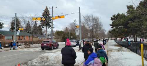
Image of McCowan Road. Photo credit: Anna Kim
Scarborough Community Council approved changes recommended through the Eglinton-Bendale South Streets Plan. A copy of the staff report is available at SC32.22.
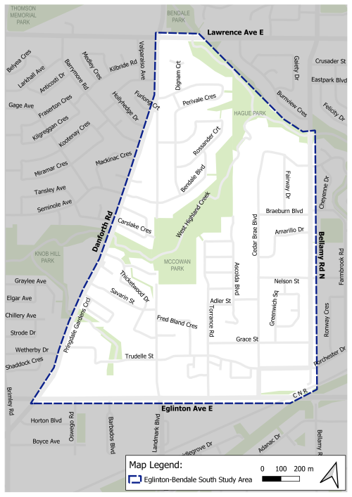
The Eglinton-Bendale South Streets Plan focuses on the neighbourhood between Lawrence Avenue East and West Highland Creek to the north, Eglinton Avenue East to the south, Bellamy Road North to the east, and Danforth Road to the west.
The study area covers segments of two City neighbourhoods: Eglinton East and Bendale South.
The Eglinton-Bendale South area was nominated for a Neighbourhood Streets Plan (NSP) by members of the local community. Each year, the City receives a far greater number of requests for neighbourhood scale traffic management, road safety, and active transportation plans than can be fulfilled. The NSP program has established an annual selection process to allocate the available resources for this service in a fair and transparent manner that considers equity, impact, alignment with planned roadwork, and community support. More information on the nomination and selection process can be found on the NSP webpage at toronto.ca/nsp.
Issues identified in the area include excessive speeding, aggressive driving, the need for improvements of walking and cycling routes, and school areas with traffic volume and road safety issues.
Neighbourhood Streets Plans (NSPs) are a new service for neighbourhoods where traffic and travel patterns challenge the safety and mobility of people using the streets. Through the NSP process, a team of City staff will work with communities to identify local issues and opportunities, prioritize the greatest needs, and recommend changes to traffic operations and street designs.
NSPs consider the needs of all road users and emphasize the safety of vulnerable road users such as seniors, school children, and people walking and cycling.
NSPs follow several steps outlined below, and public consultation takes place in two stages.
NSPs will result in a range of proposals, from quick wins to long-term changes:
The outcomes of each NSP will be different based on local conditions and the needs of each neighbourhood. Generally, NSPs will recommend actions related to motor vehicle speed, motor vehicle volume, and traffic safety conflicts on local streets. NSP recommendations are informed by the City’s Traffic Calming Guide, Vision Zero Action Plan, Complete Streets Guidelines, TransformTO Climate Change Action Plan and Toronto Seniors Strategy.
The City of Toronto is inviting local residents, businesses and organizations to learn more and provide feedback on the Eglinton-Bendale South Streets Plan. Public and community interest groups’ opinions, along with technical and policy considerations will be used to inform City staff recommendations and decisions to be made by City Council.
Consultation will take place over two phases between Winter 2025 and Fall 2025.
Information, reference materials, and reports on public consultation activities will be posted here.
A Public Drop-In Event was held on February 18, 2026 that included the opportunity to speak with project staff and view display boards. View the display boards below.
Public feedback, along with technical and policy considerations will be used to inform City staff recommendations and decisions to be made by City Council.
See map on page 19 of the information panels.
(primarily addressed through the safety improvements proposed under Conflict Management)
See map on page 22 of the information panels.
Residents have raised concerns about traffic volumes within the neighbourhood. The study identified two main sources of these concerns: school-related congestion during drop-off and pick-up times, and non-local drivers using neighbourhood streets to bypass busier corridors such as Danforth Road and Eglinton Avenue East.
Based on site visits and recent traffic data, the study found that traffic volumes on all neighbourhood streets, including those near schools, are at or below the applicable volume thresholds for motor vehicle traffic. Local roads typically carry up to 2,500 vehicles per day, and collector roads typically carry between 2,500 and 8,000 vehicles per day. Overall traffic volumes on neighbourhood streets are within these ranges and no additional traffic volume management measures are proposed at this time.
Instead, the focus is on neighbourhood-wide measures, including new parking restrictions in school zones, speed humps, and other speed management treatments, which can help discourage shortcutting by non-local traffic.
In addition, a green advisory sign stating “No Exit to Lawrence” is proposed at Eglinton Avenue East and along McCowan Road to inform drivers that McCowan Road does not provide a through connection.
See map on page 23 of the information panels.
Sign up to receive project updates by email.