August 2025 Update: The City has installed bikeways and other safety improvements on Hallam Street (Dufferin Street to Bartlett Avenue), Millicent Street (Emerson Avenue to Dufferin Street), Wallace Avenue (Lansdowne Avenue to St. Clarens Avenue) and Emerson Avenue (Dupont Street to Bloor Street). View the ‘Common Questions’ section for more information on parking changes.
The Wallace Emerson Neighbourhood Streets Plan (NSP) identified, prioritized and recommended improvements to traffic operations and street design to improve local streets and create a safer neighbourhood. Drawing on input from community members and local stakeholder groups, as well as data collected through traffic studies, the plan considered the needs of all road users in the neighbourhood including vulnerable road users such as seniors, school children, and people walking and cycling.
The study considered Traffic Calming, Vision Zero, and Complete Streets measures to address community concerns around:
The plan recommended short-term improvements (1-3 years), which will be made using quick build materials like paint and bollards, as well as more permanent long-term improvements, which typically take three or more years to implement.
July 2025- Installation Notice
Installation of bikeways on Wallace Avenue and Emerson Avenue is expected to take place between July 28 to August 2, 2025, with additional intersection improvements by Fall 2025. Details on what to expect during installation are available in the Installation Notice.
April 2025: Starting in April and May, the City will begin installation of cycle tracks on Hallam Street between Dufferin Street and Bartlett Avenue, a contra-flow bikeway on Millicent Street between Emerson Avenue and Dufferin Street and intersection improvements at Dufferin Street and Millicent Street and Hallam Street. View the Installation Notice for more details.
January 2025: The Wallace Emerson NSP was initiated to identify, prioritize and recommend improvements to traffic operations and street design to improve local streets and create a safer neighbourhood. The study considered measures to address community concerns regarding motor vehicle volumes and speeding on local roads, traffic conditions near schools and safety of vulnerable road users.
In September 2024, Toronto and East York Community Council adopted the Wallace Emerson NSP (TE16.43).
The next phase of work is implementation of the adopted recommendations, including:
Road Safety
Speed
Speed humps:
Speed bumps:
Motor Vehicle Volume
Active Transportation
Another update will be issued to you ahead of the February 2025 Infrastructure and Environment Committee meeting.
Impact of Bill 212 on Proposed Bikeways
The Wallace Emerson NSP proposes the installation of several bikeways and no vehicle lane removals are required to accommodate the bikeways. The City continues to engage the province to better understand the impact of the Bill on future installation of bikeways.
October 2024 Update: Toronto and East York Community Council has adopted the Wallace Emerson Neighbourhood Streets Plan. A copy of the adopted staff report is available at TE16.43.
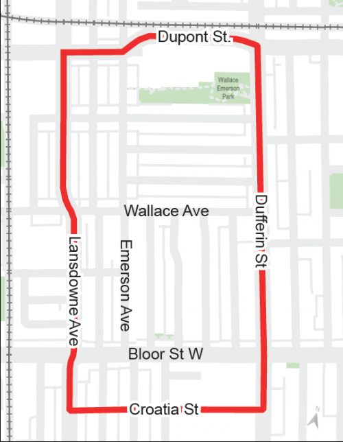
The Wallace Emerson Neighbourhood Streets Plan (NSP) study area is bounded by Lansdowne Avenue to the west, Dufferin Street to the East, Dupont Street to the north and Croatia Street to the south. It is primarily a residential community of single-family homes with commercial and retail uses concentrated on Bloor Street. There are three schools located in the area: Pauline Junior Public School, St Sebastian’s Elementary School and the Bloor Collegiate School, temporarily relocated from its original location at Bloor Street and Dufferin Street.
Anticipated travel patterns of new community members moving into the area and/or using the new Wallace Emerson Community Centre and parks were considered in the planning process.
Toronto and East York Community Council adopted a report to proceed with the following changes:
Road Safety
Intersection geometric safety improvements at the following intersections:
Closure to motor vehicles in the following area:
Speed
Traffic calming measures on the following streets:
Motor Vehicle Volume
Conversion to one-way eastbound travel on Wallace Avenue, from Lansdowne Avenue to St. Clarens Avenue.
Active Transportation
Bikeways on the following streets:
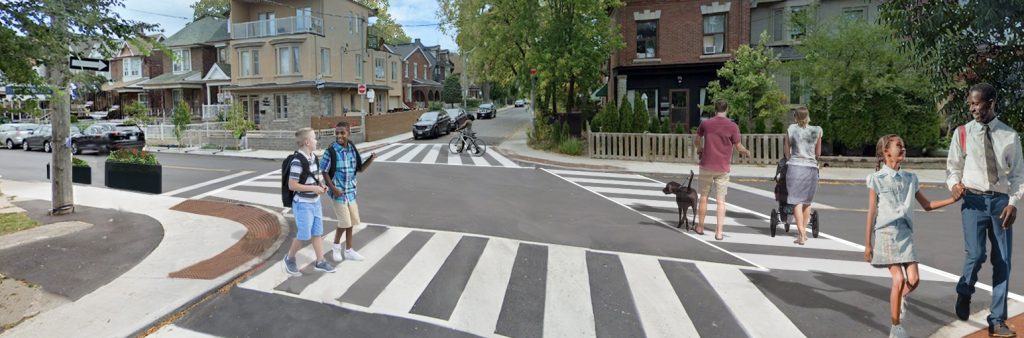
The installation of cycle tracks on Hallam Street between Dufferin Street and Bartlett Avenue has been completed, in response to the community’s desire for a safer east-west local bikeway. The bikeway provides a connection a contraflow bikeway on Millicent Street through the expanded intersection at Dufferin Street to Hallam Street. The bikeway connects to the newly installed bikeway on Bartlett Avenue.
Key changes include:
Parking Changes
Installation work on both Wallace Avenue and Emerson Avenue is now complete. All parking spaces have been retained. New pavement markings clarify how far from an intersection parking is permitted.
Parking on Emerson Avenue
On Emerson Avenue, between Dupont Street and Bloor Street, the configuration of permitted parking is now permanently on the west side of the street (between Dupont Street and Lappin Avenue) or the east side of the street (between Wallace Avenue and Lappin Avenue), and no longer requires vehicle owners to move their car on the first day and fifteenth day of the month between April 1 and October 31.
Since installation, the City has received feedback that the changes prevent parking on the opposite side of the street from the permitted parking. Residents have said that some drivers, including Accessible Parking Permit holders, have been parking on both sides of the street any time of the month without experiencing any enforcement (i.e. receiving parking tickets). The Accessible Parking Permit webpage has been updated to clarify that the following prohibition applies to Accessible Parking Permit holders: ‘no parking on a street that has two lanes or less for travel when there is a permitted parking area available on one side of that street’ as stated in Chapter 903 of the Toronto Municipal Code.
Parking on Wallace Avenue
Parking on Wallace Avenue is unchanged. There is parking permitted on the south side of Wallace Avenue between Lansdowne Avenue and St Clarens Avenue, and parking permitted on the north side of Wallace Avenue between St Clarens Avenue and Emerson Avenue.
Phase 1 Consultation
A public Drop-in Event was held on February 16, 2023. It provided residents and stakeholders with an opportunity to view project information panels and speak with members of the project team one-on-one. View the public event materials below:
Phase 2 Consultation
A Public Drop-in Event was held on March 25, 2024. It provided residents and stakeholders with an opportunity to view project information panels and speak with members of the project team one-on-one. View the public event materials below:
Interest Group Interviews
Individual one-on-one meetings with local interest groups like schools, businesses and other local organizations helped confirm local issues and identify specific opportunities and challenges (e.g. school drop off and pickup, nearby intersections, parking, etc.).
What is a Neighbourhood Streets Plan?
Neighbourhood Streets Plans (NSPs) are a new service for neighbourhoods where traffic and travel patterns challenge the safety and mobility of people using the streets. Through the NSP process, a team of City staff will work with communities to identify local issues and opportunities, prioritize the greatest needs, and recommend changes to traffic operations and street designs.
NSPs consider the needs of all road users and emphasize the safety of vulnerable road users such as seniors, school children, and people walking and cycling.
In response to concerns about traffic conditions in the Wallace-Emerson community, local residents formed the Wallace Emerson Traffic Management Committee (WETMC) in 2019. The group prepared a traffic plan for the neighbourhood which included requests for various traffic calming measures including speed humps, staggered parking with bump outs and planters, new stop-controlled intersections, turning prohibitions, and contraflow bikeways. The plan was endorsed in principle by the Toronto and East York Community Council in March 2020 (See decision TE14.46), and since that time a number of the recommended changes have been implemented.
Since Community Council’s endorsement, changes in the neighbourhood have presented new issues and new ideas and concerns have been raised in other locations in the neighbourhood that are not addressed in the WETMC plan. Given the community aspirations for local traffic management and safety improvements, travel patterns in the neighbourhood, and the future growth expected around the neighbourhood, Toronto and East York Community Council directed City staff to build on the work of the WETMC by developing a Neighbourhood Streets Plan to apply holistic approach to address traffic issues across the neighbourhood network as a whole.
NSPs follow several steps outlined below, and public consultation takes place in two stages.
NSPs will result in short-term actions (1 to 2 years) which can be made using temporary, flexible materials like signs, paint, and bollards, and will identify longer term changes which can be accomplished alongside future programmed road work.
The outcomes of each NSP will be different based on local conditions and the needs of each neighbourhood. Generally, NSPs will recommend actions related to motor vehicle speed and volume management, and traffic safety conflicts on local streets. NSP recommendations are informed by the City’s Traffic Calming Guide, Vision Zero Action Plan, and Complete Streets Guidelines.
To receive construction updates by email, subscribe to the project email.