The City of Toronto is carrying out a study to identify City water and sewer infrastructure within the West Humber River that is at risk of damage as a result of erosion caused by high flows from storms and snow melt.
The study identifies solutions to stabilize the riverbed and banks where infrastructure is at risk to ensure the City’s water and sewer infrastructure can continue to operate and service residents and businesses. The solutions will be part of a West Humber River Geomorphic Systems Master Plan (GSMP) that is implemented over a multi-year period.
Understanding Streams
The geomorphology of a stream examines how natural and human factors have shaped its form and function over time. Erosion can affect the path a stream follows (form) and the aquatic and terrestrial habitats the stream supports (function). Erosion results in gradual changes to the form and function of the stream and stream bed. Significant changes to water levels contribute to increased erosion.
During storm events, rain water or snow melt runoff enters underground pipes via drains and catch basins on streets and in parks and is discharged from storm sewer outfalls, or flows overland, into watercourses that flow to Lake Ontario. At times these flows can be high, resulting in erosion damage. High flows from past storms have caused substantial erosion damage to sewers and watermains located in and near the City’s ravines and watercourses.
This erosion damage can:
- Destabilize the soil near sewers and watermains
- Expose or break buried sewers and watermains
- Damage storm outfalls, erosion control structures, the bottom or banks of the watercourse and aquatic habitats
To learn more about erosion in streams and rivers, see the Understanding Streams Infographic or the Understanding Streams presentation slides.
Study Area
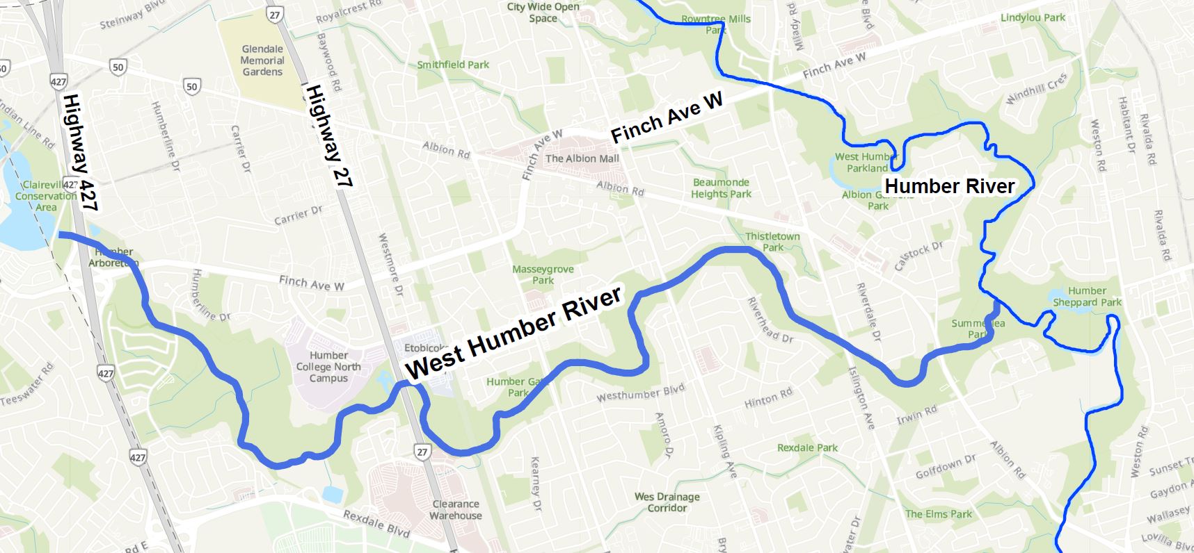
The map below shows the location of West Humber River and area under study.
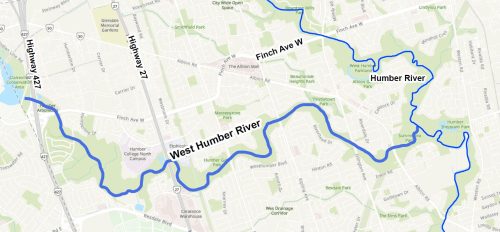
The study area is the 19 km length of West Humber River in Toronto from Highway 427and Disco Road in the west to where it meets the Humber River in the east.
Study Process
Study Purpose
The purpose of the study is to develop a Geomorphic Systems Master Plan (GSMP) for the West Humber River that will include recommendations for stabilizing the river and protecting water infrastructure from erosion.
Through the study the City will:
- Identify concerns related to erosion that may damage the City’s infrastructure
- Develop solutions that protect the City’s water and sewer infrastructure from excessive erosion processes within the stream
- Improve stream functions, such as increasing stream bank stability, reducing erosion, enhancing stormwater conveyance, and improving habitats
The study will not examine trail conditions or recommend improvements to trails, forestry or park amenities.
Study Process
The study is following the Municipal Class Environmental Assessment study process for Master Plans, which is an approved planning process under the Ontario Environmental Assessment Act and includes opportunities for public input.
This study includes the following key steps:
- Identify the problem or opportunity to be studied
- Collect data, perform fieldwork and examine existing and future conditions
- Develop, evaluate and recommend solutions
- Consult public, review agencies, utilities
- Complete study report and make available for public review
- Prioritize infrastructure protection projects
Study Details
Infrastructure Risk Assessment
The study area includes 83 water infrastructure sites and over 11 km of sanitary sewer lines including:
- 21 sanitary sewer sites and 19 sewer crossings, which carry waste water to treatment plants
- 9 watermain sites, all of which are watermain crossings, which carry drinking water
- 34 storm sewer outfalls where stormwater runoff enters the river
The level of erosion risk to the City’s sewer and water infrastructure was assessed for 59 water, stormwater and sanitary sewer infrastructure sites close to the river. The assessment evaluated the likelihood of exposure and/or failure at each of the sites.
Very Low-Risk Sites
- Infrastructure and site conditions are very stable
- Limited monitoring is required
Medium-Risk Sites
- Infrastructure and site conditions are relatively stable
- Limited/some monitoring may be required
High-Risk Sites
- Infrastructure is not exposed; exposure anticipated due to minimal depth of cover and/or high downcutting rates
- Regular monitoring is required
Very High-Risk Sites
- Infrastructure is exposed and at risk of failure; requires immediate attention
- Regular monitoring and improvements to the infrastructure are required
Alternative Solutions
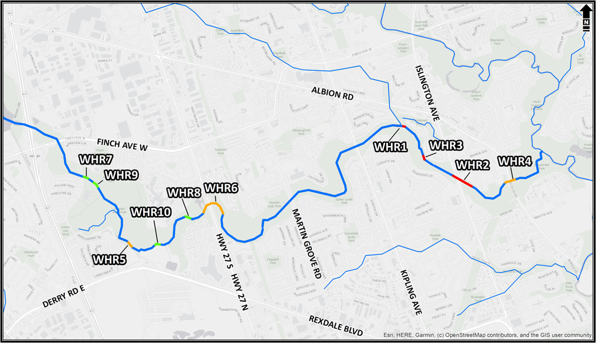
Based on the risk assessment, alternative solutions for stabilizing the riverbed and banks were evaluated for the 15 sites most at risk.
Alternative 1: Do nothing
- No planned interventions
- Ongoing monitoring
Alternative 2: Local works
- Single phase construction over a short section of channel subject to city-wide priority and budget availability
- Project sites generally less than 100 m in length
- Local bed and/or bank work in the river to protect Toronto Water infrastructure
Alternative 3: Work in an extended segment of the river (otherwise referred to as ‘reach’ or ‘sub-reach’)
- Single or multiple phase construction over a long section of channel subject to City-wide priority and budget availability
- Project sites generally greater than 100 metres
- Engineered channel design consisting of bed and bank work in the river and floodplain to protect Toronto Water infrastructure
- Channel will be regraded or locally realigned to improve river flow by reducing water velocities and erosion
Evaluation Framework
Potential solutions were evaluated against five criteria.
- Infrastructure risk: Addresses erosion and risk to City’s water and sewer infrastructure
- Physical & Natural Environment: Improves stability of stream and valley walls, flood conveyance, groundwater quality, vegetation, aquatic and terrestrial habitats including habitat for at-risk species, and minimal tree removals
- Economic Considerations: Sound total capital costs against recurring costs for maximum improvements and outcomes over a span of 30 years
- Social & Cultural Environments: Protects built and cultural heritage as well as landscape and archaeological resources and assesses long term benefits for the community, minimum or short term negative impacts, and consideration for impacts on private property
- Technical & Engineering Considerations: Passes regulatory agency standards, availability of staff and technical resources, maximum improvement for ecosystem and infrastructure.
Recommended Solutions
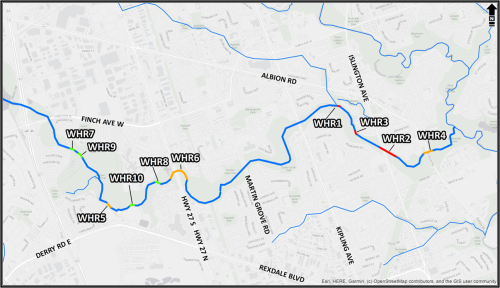
The City is recommending protection for the 15 most at-risk water infrastructure sites through 10 projects to stabilize the river and river bed.
- Seven local works projects are recommended to stabilize the river through natural channel design in a segment of the river less than 100 metres (Alternative 2)
- Three projects are recommended to stabilize the river through natural channel design in an extended segment of the river greater than 100 metres (Alternative 3)
Recommended projects have been assigned priority levels for implementation. Exposed sanitary sewers are the highest priority projects as they pose greater negative impacts if broken as compared to broken storm sewer outfalls or watermains.
- Three projects are high-priority
- Three projects are medium-priority
- Four projects are low-priority
Potential impacts
- Future implementation of the recommended projects require:
Tree and vegetation removal followed by native species replanting. Many of the tree removals include non-native species.
- Re-naturalisation areas will be densely planted with a diversity of species to promote a variety of layers in vegetation (ground cover, understory, canopy) and a mixture of fast and slower growing trees.
A restoration plan to be developed prior to construction as part of a future design phase after the study.
Construction Impacts
- Possible park trail closures to accommodate construction activities. . Details will be confirmed and shared prior to the start of construction.
Construction notices will be distributed to residents prior to any future construction.
Public Consultation
The comment period for this consultation has closed. A virtual Public Meeting was held on March 18, 2025, that included a presentation and Question & Answer period. View the presentation below.
Consultation Materials
Next Steps
Following public consultation, an Environmental Study Report will be prepared with the final study recommendations. The study report will be posted on the project webpage for a 30-day public comment period.
Stay Informed
To receive study updates by email, please email WestHumberRiver@toronto.ca and indicate that you would like to be added to the mailing list.
Date modified: October 16, 2025