West Parkdale Cycling Connections were installed in fall 2024 and fall 2025 to connect gaps in the cycling network from The Queensway to Brock Avenue and create safe cycling facilities with access to destinations like High Park, St. Joseph’s Health Centre, retail, transit, and schools. This project and associated changes were approved by City Council in June 2024 (2024.IE14.4) and by Toronto and East York Community Council in October 2024 (2024.TE17.34) and June 2025 (2025.TE23.49). This project has now entered a monitoring phase, during which the City will continue to conduct traffic counts and on-site observations.
The City does not plan to remove West Parkdale Cycling Connections. The bikeway fulfills several City policy priorities, and the project and associated changes were approved by City Council in June 2024 (2024.IE14.4) and by Toronto and East York Community Council in October 2024 (2024.TE17.34) and June 2025 (2025.TE23.49). More about the background and rationale for the project can be found in the public information panels shared during public consultation.
West Parkdale Cycling Connections was tendered and installed in 2024. It is therefore exempt from Provincial Bill 212 (“Reducing Gridlock, Saving You Time Act”).
This project has now entered a monitoring phase, during which the City will continue to conduct traffic counts and on-site observations. At this time, comments sent to the project email inbox will continue to be reviewed and recorded for response where necessary.
Transportation Services studies and proposes road safety project recommendations to City Council. Final decisions are made by City Council and in some cases, such as traffic calming, Community Council.
Recommendations are developed through consideration of three factors: City policies and programs; technical requirements; and public input.
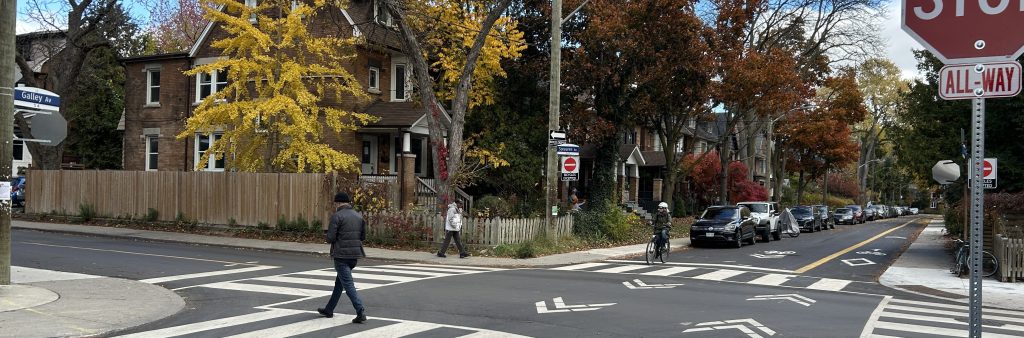
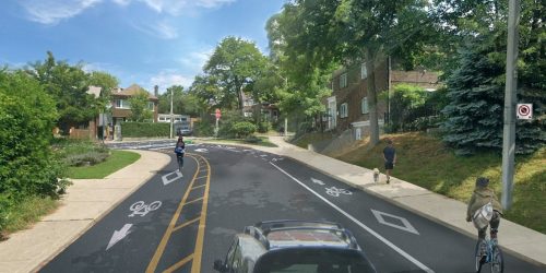
West Parkdale Cycling Connections uses the City’s Neighbourhood Greenways design approach. Neighbourhood Greenways are routes where vulnerable road users (pedestrians and people cycling) are given priority through design changes that result in lower motor vehicle volumes and speeds. One way to achieve lower motor vehicle volumes is to use one-way streets to interrupt convenient cut-through routes and encourage non-local driving trips to remain on major corridors.
For an All Ages and Abilities shared bikeway (in which people cycling share road space with people driving), the City’s target maximum motor vehicle volume is 50 per hour, with an upper limit of 75 per hour. The City’s traffic counts found that these thresholds were exceeded along the route both before and during the King-Queen-Queensway-Roncesvalles (KQQR) construction. Therefore, a major focus of the project was to reduce motor vehicle volumes along the bikeway. This was achieved by implementing one-way street direction changes to interrupt common cut-through routes.
The goal of West Parkdale Cycling Connections was to create an east-west bikeway on local streets between The Queensway and Brock Avenue. While there is another existing east-west two-way bikeway on Fermanagh Avenue that leads to High Park Boulevard and Parkside Drive, Parkside Drive itself does not connect to The Queensway.
During preliminary analysis and planning, a number of parallel local streets within the West Parkdale neighbourhood were reviewed for feasibility to implement an east/west cycling connection between The Queensway and Brock Avenue, and different configurations for street direction changes were evaluated for their potential impacts to traffic patterns and neighbourhood access.
While people may continue to choose to cycle on other streets in the neighbourhood, West Parkdale Cycling Connections were installed as a formal bikeway that the City is inviting people of All Ages and Abilities to use. Streets used for this bikeway are therefore held to different standards than other local or collector streets, including a requirement for lower motor vehicle volumes than what might be typical on other streets.
Some streets in the area have older shared lane markings (also known as “sharrows”), which are road markings that are meant to alert all road users to the presence of bicycle traffic on the street. Streets with shared lane markings are not necessarily considered dedicated cycling facilities and may not conform to the City’s On-Street Bikeway Design Guidelines, which were updated in 2023. For example, Sorauren Avenue has shared lane markings that were first installed in 2013, but its motor vehicle volumes are higher than current City standards for a shared condition bikeway.
The City’s traffic counts are conducted by third party contractors that use either midblock Automated Traffic Recorders (ATRs), which are tubes on the street that measure speed and volume of motor vehicles, or Turning Movement Counts (TMCs), which capture movements of all modes at an intersection. All ATR and TMC traffic data are available to the public through the City’s Open Data Portal databases for Midblock Vehicle Speed, Volume and Classification Counts and Multimodal Intersection Turning Movement Counts.
During preliminary analysis and planning, traffic counts were used to generate and evaluate bikeway types, routes and options for speed and volume management. Traffic counts used for project planning were conducted on weekdays in 2019 and 2022-2024; counts completed during the 2020 and 2021 pandemic lockdowns were not used.
Following public consultation, the City conducted additional counts in April and June 2024 in order to study community requests for stop signs or traffic calming.
Typically, post-installation traffic counts are collected along bikeway routes and on adjacent streets and laneways in the 6 to 12 months following installation. This period allows for road users to adjust their travel patterns based on changes implemented as part of a project. However, based on early feedback about traffic circulation changes in the project area, the City collected preliminary post-installation traffic counts at 26 locations in the project area in October and November 2024 to better understand residents’ concerns and make recommendations to address them.
In fall/winter 2025/2026, the City will again conduct traffic counts along the project route and on adjacent streets and laneways as part of post-installation monitoring.
While local resident efforts to monitor traffic are appreciated, staff will continue to rely on official ATR and TMC data as noted above in accordance with City policy.
As part of West Parkdale Cycling Connections, some on-street parking spaces were removed around intersections in the project area, including around intersections that were not adjacent to the bikeway. While the City aimed to minimize parking impacts for this project, these on-street parking removals were made to improve sight lines and ensure adequate space for large vehicles like fire trucks and garbage trucks to safely turn onto the street. A City bylaw already prohibits parking within 9 metres of any intersection, even if a no parking sign is not present, but a larger setback is often found to be necessary on narrower streets to enable safer turns. When a larger setback is found to be necessary, the above bylaw allows the City to prohibit parking within up to 15 metres of an intersection if signed. The traffic engineering analysis that led to these on-street parking removals was conducted as part of the City’s standard practice for projects that propose changes to the street network, to ensure that any necessary safety improvements can be bundled into the existing project.
The City works to improve road safety through road design, as noted in the City’s Complete Streets Guidelines and Vision Zero Road Safety Plan. The following reporting helps Toronto Police Services to better understand where officers can best be distributed to enforce traffic safety:
In fall/winter 2025/2026, the City will conduct traffic counts along the project route and on adjacent streets and laneways as part of the City’s standard practice of post-installation monitoring for approximately 12 months after installation.
It takes time for people to adjust to change. Motor vehicle traffic patterns may take several months to stabilize, and cycling volumes may take multiple years to grow. The City does not set a minimum cycling volume to determine the success of a bikeway, just as there is no minimum pedestrian volume to determine the success of a sidewalk.
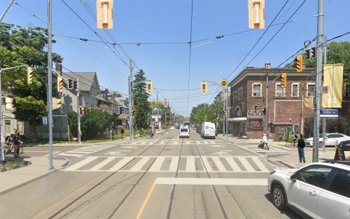
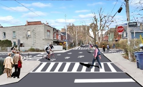
West Parkdale Cycling Connections is a bikeway route from The Queensway to Brock Avenue along Glendale Avenue, Merrick Street, Claude Avenue, Parkdale Road, Sunnyside Avenue, Galley Avenue, Macdonell Avenue, and Seaforth Avenue. Associated changes have been implemented on Sunnyside Avenue, Macdonell Avenue, Fern Avenue, Pearson Avenue, and Maple Grove Avenue. The project goals are to improve safety and conditions for all road users, minimize impact to on-street parking, and reduce local traffic infiltration.
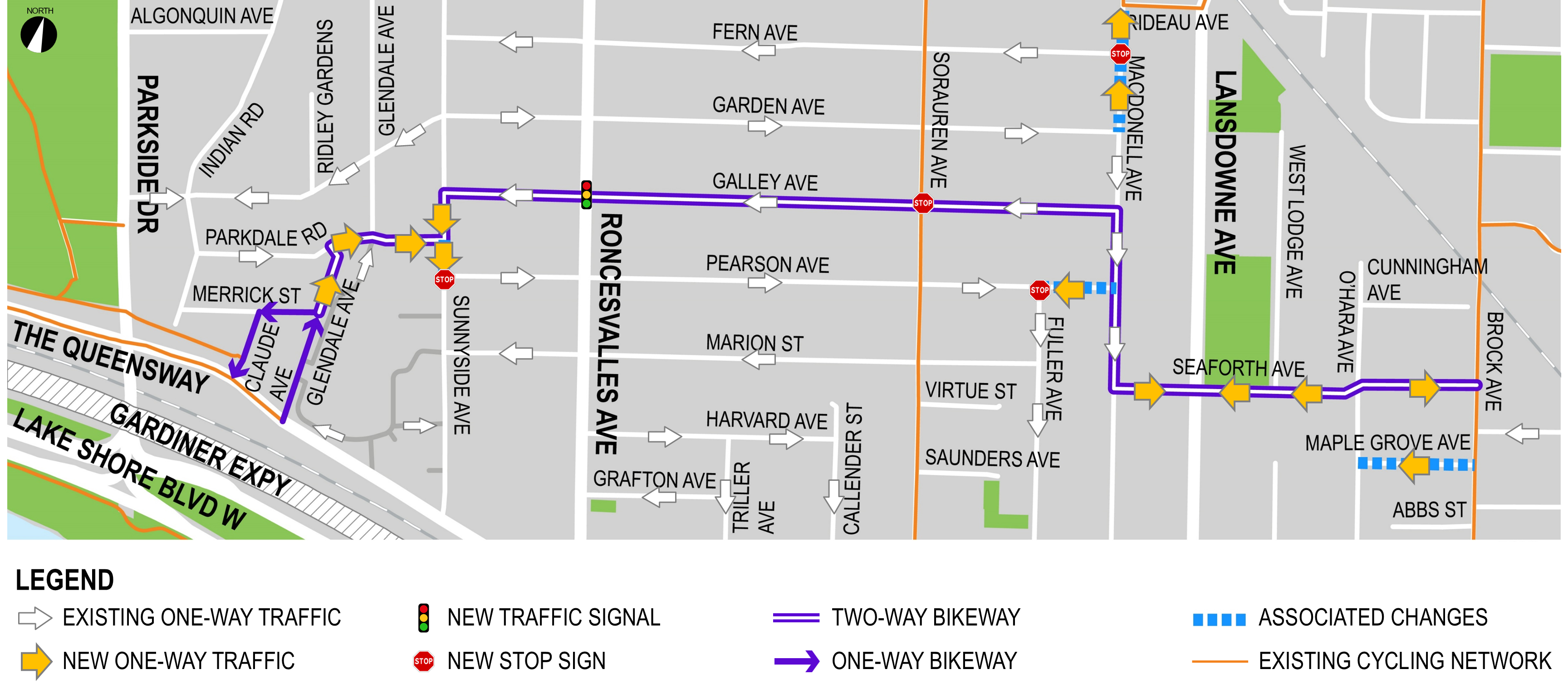
In this area, changes were implemented to slow vehicle speeds and reduce non-local traffic infiltration while maintaining emergency entrance access and clockwise circulation around St. Joseph’s Health Centre and preserving parking adjacent to the hospital.
In this area, changes were implemented to slow vehicle speeds and reduce vehicle volumes.
In this area, changes were implemented to slow vehicle speeds and reduce vehicle volumes.
Improvements were made at intersections in the project area where community feedback indicates safety concerns including high-speed vehicle turns, poor sight lines, lack of pedestrian amenities and recent collisions. In some cases, these improvements were installed in two phases.
Seaforth Avenue and O’Hara Avenue:
Public consultation for this project took place between October 2023 – March 2024. An additional update was shared through a virtual public meeting in February 2025. Learn more by reading the consultation report and reviewing the materials linked below.
Staff thoroughly investigated the comments shared during the public consultation period while weighing other factors, including City safety standards and traffic counts. Based on their analysis, their recommendation, which was approved by City Council, was to implement the originally proposed design while also continuing to study community requests for additional stop signs and speed humps along the bikeway route. After installation, the City is also continuing to monitor the project area, conduct additional traffic counts, and make additional adjustments as needed.
This project and associated changes were approved by City Council in June 2024 (2024.IE14.4) and by Toronto and East York Community Council in October 2024 (2024.TE17.34) and June 2025 (2025.TE23.49).
City Council approved the implementation of a bikeway and traffic changes in West Parkdale to help fulfill the City’s commitment to the Vision Zero Road Safety Plan. Vision Zero’s goal is to eliminate traffic-related fatalities and serious injuries by making our roads safer for everyone, especially for seniors, school children, pedestrians, and people cycling. In the past 10 years, there have been 227 reported collisions along the recommended route, in which eight have involved pedestrians, and 12 have involved people cycling. All approved changes are focused on reducing future collisions, injuries, and fatalities.
This project also fulfills the City Council-directed Cycling Network Plan for 2022-2024 and to take advantage of the planned watermain rehabilitation and road resurfacing on Galley Avenue. The Cycling Network Plan is a comprehensive roadmap and work plan that outlines the City’s planned investment in our cycling network. The aim of the Cycling Network Plan is to connect gaps in Toronto’s current cycling network by growing existing and future cycling opportunities with safer and more comfortable cycling route options where quality can be improved.
The approved design meets City of Toronto and Province of Ontario laws, standards and guidelines. The changes have been reviewed by City services that use the area roadways, so that Toronto’s Fire Services, Paramedics, Police, Solid Waste pickup, TTC, Wheel-Trans, road maintenance and snow clearing can continue to function well and serve the community.
While we aim to provide fully accessible content, there is no text alternative available for some of the content on this page. If you require alternate formats or need assistance understanding our maps, drawings or any other content, please contact us by email WestParkdaleCycling@toronto.ca.