The Archives has many resources about the former municipalities that existed before the municipal amalgamation of 1998. To learn more about what types of records are within our collection, many of which are organized by municipality, see What's in the Archives. To learn how to search and request records from our collection, see Using the Database.
For post-amalgamation City of Toronto records, and more information, see Government Records. For current City records, see How to Access City Information.
Even when it was a modest city of 9,000 and was known as “Muddy York,” Toronto was the commercial and financial hub of its large agricultural county. The history of the City of Toronto is the history of not only the city government but also of the people, organizations, and businesses that have shaped the city.
The proceedings of the City of Toronto Council from 1834 to 1997 are available in the Research Hall in printed format. For more information, see Council Proceedings.
Many former City of Toronto’s by-laws can be found online in the City’s By-law Status Register. Most by-laws are also available on microfilm and many are printed within the Council minutes, available in the Research Hall. For more information, see By-Laws.
Former Toronto Assessment rolls (property tax records) from 1834 to 1997 are available on microfilm or microfiche in the Research Hall. For more information, see Assessment Rolls.
Published reports and other records created by the former City of Toronto cover a wide range of topics, such as public transit, social services, public health; public works, emergency services and many Council committees. There are also records from former municipalities that were annexed to Toronto, such as Parkdale, North Toronto, and Yorkville.
Records of the former Metro (regional) government also include information relevant to Toronto. See below for more information on these records.
Many reports are included within the Council Minutes. For more information see Government Records. You can also search our online database.
Fire insurance plans from 1880 to 1924 are available to view online. Later maps up to the 1970s are available on microfilm in the Research Hall. These later maps do not cover the entire city, but mainly focus on industrial and commercial areas.
The Archives has city directories for most years from 1834 to 2001. City Directories are available online.
Many maps are available to view online. You can also use our online database to search for maps of Toronto. There are also several atlases and maps available in the Research Hall.
Aerial photographs cover the Toronto area from 1947 to 1992. A selection of years are available online. A smaller group of photographs of valley lands from 1937 to 1942 are also available online.
These general reference books are available in the Archives Research Hall Library and are a good place to start your research:
Frederick H. Armstrong, Toronto, The Place of Meeting
(Burlington: Windsor Publications 1983)
971.3541 AR5 1983
Eric Arthur, Toronto, No Mean City
(Toronto: University of Toronto Press 1974 and 1986)
720.9713541 AR7 1974 or 1986
J.M.S. Careless, Toronto to 1918:An Illustrated History
(Toronto: J. Lorimer 1984)
971.3541 C18 1984
James Lemon, Toronto Since 1918: An Illustrated History
(Toronto: Lorimer and National Museum of Man 1985)
971.3541 L54 1985
Jesse Edgar Middleton, The Municipality of Toronto Canada:
A History (3 volumes) (Toronto and New York:
Dominion Publishing Company 1923)
971.3541 M58 1923
Books on more specific Toronto topics may be found by searching in the online database. These topics include places (such as the Toronto Islands and Yonge Street), institutions (such as the TTC), people, and events.
Major photographic collections include the Globe and Mail collection (Fonds 1266), which includes images of major national events (such as the Royal Visit of 1939 and World War II home front activities) as well as local highlights (such as the annual Santa Claus Parade and the Canadian National Exhibition) and fashion and entertainment coverage in the 1930s and 1940s.
The William James Family fonds (Fonds 1244) documents a wide range of Toronto locations, events, and people from the early 1900s to the 1940s, and the Department of Public Works collection (Series 372) shows the construction of water filtration plants, roads, bridges, and other major public works from the late 19th century to the 1940s.
The best way to find photographs is by using the online database. Almost 200,000 images have been scanned and are viewable online.
There are also reference copies of some photographs in binders and on microfilm in the Research Hall.
For general information, see the information files in the Research Hall. You may find other files about more specific topics, such as places (like Allen Gardens and Fort York), people (such as Mary Pickford and Ned Hanlan), events (such as Hurricane Hazel), and institutions.
For street name changes, see the binders titled “Street Names” and “Name Present” in the Research Hall. The binder titled “Toronto Reference Highlights” also contains some useful information
Other holdings about the former City of Toronto include those created by individuals, businesses, and groups as diverse as the Children's Aid Society (Fonds 1001), the House of Industry (Fonds 1035), residents’ and ratepayers’ associations, the Bureau of Municipal Research (Fonds 1003), and many former elected officials, including Allan Lamport, Nathan Phillips, Philip Givens, and John Sewell.
The regional government of the Municipality of Metropolitan Toronto (Metro) encompassed the geographical area we know today as simply Toronto. It coexisted with the area municipalities (thirteen in 1953, reduced to six in 1967) and was responsible for issues of regional significance and scope, such as water supply and sewage disposal, solid waste management, social services, police and ambulance services, arterial roads, and public transit.

The proceedings of Metro Council from 1953 to 1997 are available in the Research Hall in printed format. For more information, see Council Proceedings.
Many former Metro Toronto by-laws can be found online in the City’s By-law Status Registry. By-laws are also available within the printed Council minutes, available in the Research Hall. For more information, see By-Laws.
Published reports regarding Metro, include subjects such as public transit, water treatment, the environment, social services, and policing, as well as official plans and two Royal Commissions.
Many reports are included within the Council Minutes. For more information see Government Records. You can also search our online database.
Of particularly wide scope are the Metropolitan Clerk's Official Reports (Series 10), the Annual Reports of the Commissioner of Finance (Series 185) and, for public works subjects, the Works Library Reports (Series 235).
Fire insurance plans from 1880 to 1924 are available to view online. Later maps up to the 1970s are available on microfilm in the Research Hall. These later maps do not cover the entire city, but mainly focus on industrial and commercial areas..
The Archives has city directories for most years from 1834 to 2001. City Directories are available online.
To find maps showing Metro, use our online database. TTC Planning Maps (Series 260) and Maps and Plans of the Planning Department (Series 210), both of which include maps showing transit routes, roads, population, land use and other information, are of particular interest.
There are also several atlases and maps available in the Research Hall.
Aerial photographs cover the Toronto area from 1947 to 1992. A selection of years are available online. A smaller group of photographs of valley lands from 1937 to 1942 are also available online.
These general reference books are a good place to start your research:
Timothy J. Colton, Big Daddy: Frederick G. Gardiner
and the Building of Metropolitan Toronto
(Toronto: University of Toronto Press 1980) 351.713541 C72 1980
Gera Dillon and Michael McMahon, Metro Perspectives (videotape)
(Toronto: Metropolitan Toronto Archives 1991)
971.3541 D58 1991 (closed reference)
Don R. Richmond, History of Metropolitan Toronto
(draft) (Toronto 1978)
971.3541 R41 1978
Boomtown, Metropolitan Toronto: A Photographic Record of Two Decades of Growth
(Toronto: Donald Boyce Kirkup and Lockwood Survey Corp., Ltd. 1969)
917.13541 K63 1969
Metropolitan Toronto: The Changing Context, 1953-1993
(Toronto: Municipality of Metropolitan Toronto 1993)
351.713541 M56 1993
Metropolitan Toronto: Past and Present: Aerial Photos From the Collection of Gordon H. Jarrett
(Toronto: Donald Boyce Kirkup 1974)
917.1354 K63 1974
To find photographs of places and events throughout Metro, use our online catalogue. Particularly wide-ranging in subject matter is the Metropolitan Toronto Planning Board Brochure Photographs Series (Series 35), which includes images of police, parks, and cultural activities as well as the development of suburbs and infrastructure from 1948 to 1978.
Other large collections include the Road Construction Photographs (Series 3), showing roads and streetscapes throughout Metro from 1949 to the 1980s; the Works Library Photographs (Series 4), showing construction and maintenance of water, sewer, and solid waste management facilities from 1874 to 1986; and the Parks and Property Photographs (Series 316), showing parks and recreation facilities from 1924 to 1982.
For photographs of public transportation, see the Central Photography of the Toronto Transit Commission (Series 71), as well as the Strathy Smith Yonge Street subway construction views (Series 381), and the Eric Trussler Fonds (Fonds 1567), which shows construction of the University Avenue subway.
For general information, see the information files in the Research hall whose titles begin with “Metro” or “Metropolitan”. You may also find other files about more specific topics, including people (such as Mel Lastman, Fred Gardiner, and Tommy Thompson), places and landmarks (such as the Gardiner Expressway and the Martin Goodman Trail), and issues of both local and regional significance (such as housing, water quality, economic development, and GO Transit).
A list of Metro politicians and other municipal information can be found in the binder titled “Metro Reference Highlights”. Other useful sources for general information are the Metro Planning Board Brochures, the Metro Key Facts, and the Metro Briefing Notes.
Other highlights include the Eli Comay Fonds (Fonds 39) of planning records; the papers and drawings of architect Howard Chapman (Fonds 7); correspondence, subject files, and publications of the Urban Alliance on Race Relations (Fonds 40); administrative and promotional records of the Toronto Area Industrial Development Board (Fonds 42); Toronto Police records (Fonds 38); and the photographs, diaries, and other papers of conservationist Charles Sauriol (Fonds 4).
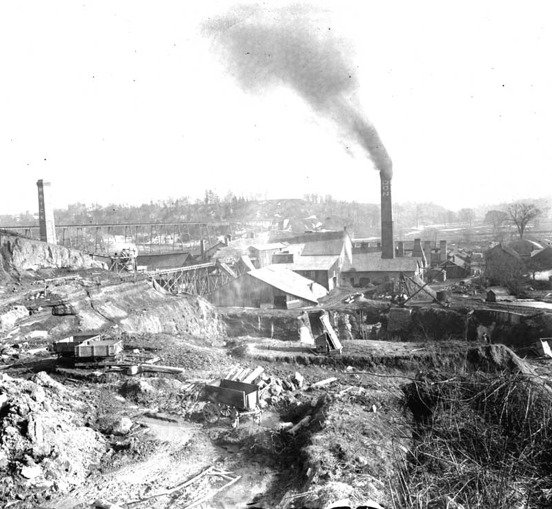
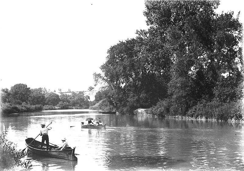
East York has left its mark on the rest of Toronto through the red bricks supplied by the Don Valley Brick Works. In more recent times, the oases of its riverside parklands have been enjoyed by people from all over the city.
The City of Toronto Archives has records, created by municipal governments as well as private groups and individuals, about East York, including personal papers; published books and reports; and visual material, including maps and photographs.
The Archives has Council proceedings for East York from 1924 to 1997, and Leaside from 1913 to 1966. See York Council proceedings for information about the area before the formation of East York. For more information, see Council Proceedings.
Many East York by-laws can be found online in the City’s By-law Status Registry. To access others you will have to contact the Archives. For more information, see By-Laws.
The archives has assessment rolls for East York from 1924 to 1997. Assessment rolls from 1950 to 1966 and 1992 to 1996 are available on microfilm and microfiche in the Research Hall. The Archives also has assessment rolls for Leaside..
For assessment information before the formation of East York, see the assessment rolls for the Township of York. For more information, see Assessment Rolls.
Published reports regarding East York, include topics such as public transit and roads. Of particular interest is the Brief of Reeve True Davidson, East York Township, to the Royal Commission on Metropolitan Government (1964).
Other East York and Leaside records are also available, as well as records of the former Metro (regional) government, which also includes information relevant to East York.
For more information see Government Records. You can also search our online database.
Fire insurance plans from 1880 to 1924 are available to view online. Later maps up to the 1970s are available on microfilm in the Research Hall. These later maps do not cover the entire city, but mainly focus on industrial and commercial areas.
Some areas of East York are listed in the Toronto city directories in a separate suburban section from 1890 to 1929. Starting in 1930, East York listings are part of the main directory.
Between 1983 and 1995, East York listings appear only in the “central” and “east” editions of the directory, which are not published every year. After 1995, East York listings appear in one volume entitled “City of Toronto (east of Yonge) and East York.” City Directories are available online.
The Archives also has a copy of a Directory and Map of the Township of York (917.13540025 ON8 1909) for 1909, which includes listings for East York villages.
Many maps are available to view online. You can also use our online database to search for maps of East York. There are also several atlases and maps available in the Research Hall.
The aerial photographs cover the East York area from 1947 to 1992. A selection of years is online. A smaller group of valley lands from 1937 to 1942 is also online.
These general reference books are available in the Archives Research Hall Library and are a good place to start your research:
Ron Brown, Toronto’s Lost Villages
(Toronto: Polar Bear Press 1997)
971.3541 B81 1997
Eleanor Darke, A Mill Should Be Built Thereon:
An Early History of the Todmorden Mills
(Toronto: Natural History/Natural Heritage 1995) 971.3541 D24 1995
True Davidson, et al., Golden Years of East York
(East York: Centennial College Press 1976)
971.3541 D28 1976
Jane Pitfield, ed., Leaside
(Toronto: Natural Heritage Books 2000)
971.3541 L48 1999
Alan Redway, East York 1924-1997:
Toronto’s Garden of Eden (Victoria: Friesen Press 2018)
971.3541 R22 2018
J.I Rempel, The Town of Leaside:
A Brief History (Toronto: East York Historical Society 1982)
971.3541 R25 1982
Books on more specific East York topics may be found by searching in the online database. These topics might include landmarks (such as Todmorden Mills) and people (such as Charles Sauriol and True Davidson).
The best way to find photographs is by using the online database. Almost 200,000 images have been scanned and are viewable online.
For general information, see the information files titled “East York” and “Leaside”. You may also find other information files about more specific topics. A list of East York mayors and other municipal information can be found in the binder titled “East York Reference Highlights”. For information regarding origins of street names and street name changes in East York and Leaside, see the the binders titled “Origins of Street Names” in the Research Hall.
Etobicoke has included a number of different landscapes and communities: prosperous farms, resorts clustered on the lakeshore, mill villages on the Humber, a commercial byway along Lakeshore Road (later Boulevard).
The City of Toronto Archives has many records, created by municipal governments as well as private groups and individuals, about Etobicoke, including government reports; personal papers; books; and visual material, including maps and photographs.
The Archives has Council proceedings for Etobicoke, Long Branch, Mimico, and New Toronto. For more information, see Council Proceedings.
Many Etobicoke by-laws can be found online in the City’s By-law Status Registry. Etobicoke by-laws from 1876 to 1975 are also available on microfilm in the Research Hall. To access others you will have to contact the Archives. For more information see By-Laws.
The Archives has assessment rolls for Etobicoke, Long Branch, Mimico, and New Toronto. Etobicoke Assessment Rolls from 1982 to 1997 are available on microfiche in the Research Hall. For more information see Assessment Rolls.
Published reports regarding Etobicoke, include topics such as the lakeshore “motel strip,” the Islington community, Woodbine Centre, and the Humber River watershed, as well as official plans.
Also available are records from the municipalities of Mimico, Long Branch and the Town of New Toronto.
The records of the former Metro (regional) government also include information about matters relevant to Etobicoke. For more information see Government Records. You can also search our online database.
Fire insurance plans from 1880 to 1924 are available to view online. Later maps up to the 1970s are available on microfilm in the Research Hall. These later maps do not cover the entire city, but mainly focus on industrial and commercial areas.
Parts of Etobicoke are listed in the Toronto city directories in a separate suburban section (see each year’s table of contents for page numbers) from 1890 to 1929. Starting in 1930, Etobicoke listings are part of the main directory. Between 1983 and 1995, Etobicoke listings appear only in the “west” edition of the directory, which is not published every year. After 1995, Etobicoke listings appear in one separate volume. City Directories are available online.
Many maps are available to view online. You can also use our online database to search for maps of Etobicoke. There are also several atlases and maps available in the Research Hall.
Aerial photographs cover the Etobicoke area from 1947 to 1992. A selection of years are available online. A smaller group of photographs of valley lands from 1937 to 1942 are also available online.
These general reference books are available in the Archives Research Hall Library and are a good place to start your research:
Ron Brown, Toronto’s Lost Villages
(Toronto: Polar Bear Press 1997)
971.3541 B81 1997
Robert A. Given, The Story of Etobicoke
(Etobicoke: Municipality of Etobicoke 1950)
971.354 G43 1950
Esther Heyes, Etobicoke: From Furrow to Borough
(Etobicoke: The Borough of Etobicoke 1974)
971.3541 H51 1974
K.M. Lizars, The Valley of the Humber, 1615-1913
(Toronto: William Briggs 1913)
971.354 L76 1913
Villages of Etobicoke
(Weston: Argyle Printing 1985)
961.3541 V71 1985
Books on more specific Etobicoke topics may be found by searching in the online database. These topics might include places, organizations, landmarks, and events.
To find photographs of Etobicoke places and events, search on your research topic in the online database. These series are a good place to start:
For general information, see the information file titled “Etobicoke.” You may also find other information files about more specific topics, such as smaller communities within Etobicoke (such as Mimico and the Kingsway), landmarks (such as Montgomery’s Inn), people, and events.
The green binder “Etobicoke Street Name Changes” will help you determine if a street name has changed.
For a list of Etobicoke mayors and other municipal information, see the binder entitled “Etobicoke Reference Highlights.”
North York has a long history, first an agricultural region dotted with crossroads and villages, then a growing suburban community, and finally a modern city. The City of Toronto Archives has many records, created by the government as well as private groups and individuals, about North York.
These records include municipal government information such as Council minutes and departmental files; personal papers; published books and reports; and visual material, including maps and photographs.
The Archives has the North York Council minutes from 1923 to 1997. Indices to the North York Council minutes from 1967 to 1996 are available to view online. For information about the area before the formation of North York, see Council proceedings for the Township of York Council. For more information, see Council Proceedings.
Many North York by-laws can be found online in the City’s By-law Status Registry. To access others you will have to contact the Archives. For more information see By-Laws.
The Archives has North York assessment rolls from 1922 to 1997. North York Assessment Rolls from 1922 to 1977 and 1982 to 1997 are available on microfilm and microfiche in the Research Hall.
For assessment information before the formation of North York, see the assessment rolls for the Township of York. For more information see Assessment Rolls.
Published reports regarding North York, include topics such as public transit, roads, and construction of the North York Civic Centre.
Other North York records are also available The records of the former Metro (regional) government and the Township of York also include information about matters relevant to North York.
For more information see Government Records. You can also search our online database.
Fire insurance plans from 1880 to 1924 are available to view online. Later maps up to the 1970s are available on microfilm in the Research Hall. These later maps do not cover the entire city, but mainly focus on industrial and commercial areas.
North York is listed in the Toronto city directories in a separate suburban section (see each year’s table of contents for page numbers) from 1924 to 1929. Starting in 1930, North York listings are part of the main directory. After 1983, the directories are published in separate “central,” “east,” and “west” volumes, though not every volume is published in every year. North York listings appear in all three of these volumes, depending on location. City Directories are available online.
The Archives also has a copy of a Directory and Map of the Township of York (917.13540025 ON8 1909) for 1909, which includes listings for North York villages.
Many maps are available to view online. You can also use our online database to search for maps of North York. There are also several atlases and maps available in the Research Hall.
The aerial photographs cover the North York area from 1947 to 1992. A selection of years is online. A smaller group of valley lands from 1937 to 1942 is also online.
These general reference books on the history of North York are available in the Archives Research Hall Library and are a good place to start your research:
Patricia W. Hart, Pioneering in North York
Toronto: General Publishing 1968
971.3541 H25 1968
Borough of North York: Historical Outline of the Administration of the Borough of North York Including Historic Sites
North York: Public Information Office of the Borough of North York
1978 or 1983 971.3541 H62 1978 or 1983
Ron Brown, Toronto’s Lost Villages
Toronto: Polar Bear Press 1997
971.3541 B81 1997
Books on more specific North York topics may be found by searching in the online database. These topics might include smaller communities within North York (such as Downsview or Oriole), church histories (such as St. John’s at York Mills), and organizations (such as North York Hydro).
To find photographs of North York places and events, search on your research topic in the online database. Of particular relevance is Images of North York (Series 249).
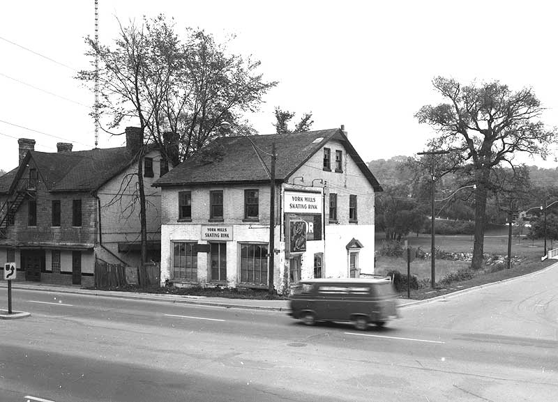
For general information, see the information file titled “North York.” You may also find other information files about more specific topics, such as smaller communities within North York (such as York Mills or Don Mills), specific buildings (such as Dempsey Store or Gibson House), parks (such as Edwards Gardens), and other landmarks or events.
Another useful source for North York history is the Baldwin Collection of Canadiana Marilyn & Charles Baillie Special Collections Centre on the 5th floor of the Toronto Reference Library.
Scarborough made its name known in the 1950s, with its famous “Golden Mile” of industry (Eglinton Avenue East) and new suburban communities, but its history as an agricultural region dotted with crossroads villages and mills goes back a century and half before that.
The City of Toronto Archives has records, created by municipal governments as well as private groups and individuals, about Scarborough, including personal papers; published books and reports; and visual material, including maps and photographs.
The Archives has Scarborough Council proceedings from 1850 to 1997, with those from 1913 to 1997 available on microfilm in the Research Hall. For more information, see Council Proceedings.
Many Scarborough by-laws can be found online in the City’s By-law Status Registry. Scarborough by-laws from 1850 to 1997 are also available on microfilm in the Research Hall. For more information see By-Laws.
The Archives has assessment rolls for Scarborough from 1853 to 1991. Scarborough Assessment Rolls from 1970 and 1982 to 1997 are available on microfiche in the Research Hall. For more information see Assessment Rolls.
Published reports regarding Scarborough include topics such as public transit, roads, and construction of the Scarborough Civic Centre.
The records of the former Metro (regional) government also include information about matters relevant to Scarborough. For more information see Government Records. You can also search our online database.
Fire insurance plans from 1880 to 1924 are available to view online. Later maps up to the 1970s are available on microfilm in the Research Hall. These later maps do not cover the entire city, but mainly focus on industrial and commercial areas.
Parts of Scarborough are listed in the Toronto city directories in a separate suburban section (see each year’s table of contents for page numbers) from 1917 to 1929. Starting in 1930, Scarborough listings are part of the main directory. Between 1983 and 1995, Scarborough listings appear only in the “east” edition of the directory, which is not published every year. After 1995, Scarborough listings appear in one separate volume. City Directories are available online.
Many maps are available to view online. You can also use our online database to search for maps of Scarborough. There are also several atlases and maps available in the Research Hall.
The aerial photographs cover the Scarborough area from 1947 to 1992. A selection of years is online. A smaller group of valley lands from 1937 to 1942 is also online.
These general reference books on the history of Scarborough are available in the Archives Research Hall Library and are a good place to start your research:
Robert A Bonis, ed., History of Scarborough
(Scarborough: Scarborough Public Library 1965 or 1968)
971.3541 B64 1965 or 1968
Ron Brown, Toronto’s Lost Villages
(Toronto: Polar Bear Press 1997)
971.3541 B81 1997
Barbara Myrvold, The People of Scarborough: A History
(Don Mills: City of Scarborough Public Library Board 1997)
971.3541 M99 1997
Scarborough Historical Notes and Comments
(Scarborough: Scarborough Historical Society)
971.354 SC7 1988
To find photographs of Scarborough places and events, search on your research topic in the online database. These series are a good place to start:
For general information, see the information file titled “Scarborough.”
For a list of Scarborough mayors and other municipal information, see the binder entitled “Scarborough Reference Highlights.”
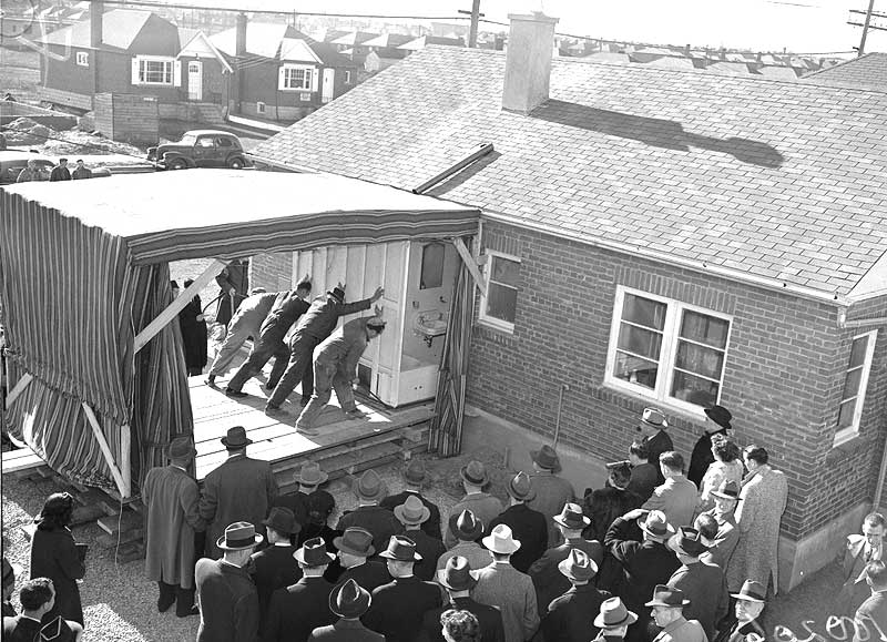
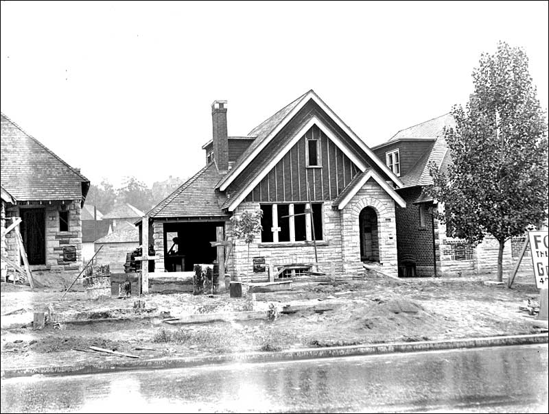
In the 19th century, the area that would eventually become the city of York was largely agricultural, with grist, lumber, and woollen mills dotting the banks of the Humber River. In the first half of the 20th century, it was a refuge for working-class families earning independence by building their own homes.
The City of Toronto Archives has records, created by municipal governments as well as private groups and individuals, about York, including personal papers; published books and reports; and visual material, including maps and photographs.
Early council proceedings from York County are found in Christine Mosser, ed., York, Upper Canada, Minutes of Town Meetings and Lists of Inhabitants, 1797-1823 (Toronto: Metropolitan Toronto Library Board 1984) in the Research Hall (call number 929.3513541 Y7 1984). The Archives has Council proceedings for York from 1860 to 1997, with those from 1860 to 1901 available on microfilm in the Research Hall. Council proceedings for Weston from 1882 to 1966, are also available. For more information, see Council Proceedings.
Many York by-laws can be found online in the City’s By-law Status Registry. To access others you will have to contact the Archives. For more information, see By-Laws.
The Archives has York assessment rolls from 1882 to 1992 and Weston assessment rolls from 1883 to 1966. York Assessment rolls from 1882 to 1899 are available on microfilm in the Research Hall. For more information, see Assessment Rolls.
Published reports regarding York, include topics such as public transit and roads, as well as official plans. Records of the former Metro (regional) government also include information relevant to York.
Also available are records from municipalities that were originally part of York. As well as the former City of Toronto and Weston, these consists of Brockton, East Toronto, Forest Hill, North Toronto, Parkdale, Swansea, West Toronto, and Yorkville.
For more information see Government Records. You can also search our online database.
Fire insurance plans from 1880 to 1924 are available to view online. Later maps up to the 1970s are available on microfilm in the Research Hall. These later maps do not cover the entire city, but mainly focus on industrial and commercial areas.
Some areas of York are listed in the Toronto city directories in a separate suburban section from 1905 to 1929. Starting in 1930, York listings are part of the main directory.
Between 1983 and 1995, York listings appear only in the “central” and “west” editions of the directory, which are not published every year. After 1995, York listings appear in one volume along with parts of the City of Toronto. City Directories are available online.
The Archives also has a copy of a Directory and Map of the Township of York (917.13540025 ON8 1909) for 1909, which includes listings for York villages.
Many maps are available to view online. You can also use our online database to search for maps of York. There are also several atlases and maps available in the Research Hall.
Aerial photographs cover the York area from 1947 to 1992. A selection of years are available online. A smaller group of photographs of valley lands from 1937 to 1942 are also available online.
These general reference books on the history of York are a good place to start your research:
J.C. Boylen, York Township: An Historical Summary
(Toronto: Municipal Corporation of the Township of York and the Board of Education of the Township of York 1954)
971.354 B69 1954
Wilbert G.Thomas, The Legacy of York: A Survey of the Early Development of the Communities of York
(Toronto: Historical Committee of the City of York 1992)
971.354 T36 1992
Wilbert G.Thomas, The Legacy of York: A Survey of the Later Developments (1920-1950) in York Township
(Toronto: Historical Committee of the City of York 1992)
971.354 T36 1996
City of York: A Local History
(Toronto: Board of Education for the City of York 1987)
971.354 C39 1987
The best way to find photographs is by using the online database. Almost 200,000 images have been scanned and are viewable online.
There are also reference copies of some photographs in binders and on microfilm in the Research Hall.
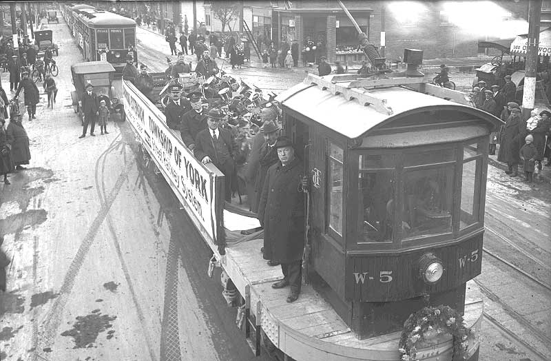
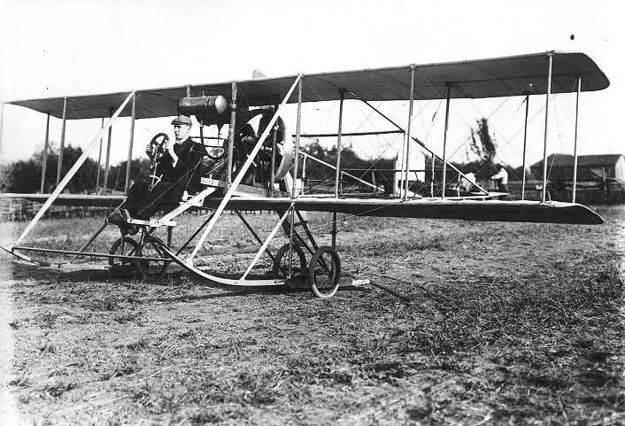
Some photographic highlights of York records available at the City of Toronto Archives include early airplane flights near Weston (Fonds 1244), the first TTC streetcar in York (Series 71), and views of Weston and York streetscapes in the 1920s (Series 71).
Highlights of other media include correspondence, plans, and notes regarding various properties in the Township of York from 1851 to 1900 (Fonds 79), including a brochure for “suburban gardens and villa residences" for sale on Balmoral Avenue, Weston (Series 346, File 105). Also of interest are the daily journals of William Abbott Parsons (1844-1923), who owned a farm near Eglinton Avenue and Dufferin Street (Fonds 85).
For general information, see the information files titled “York” and “York County 1792-1971”. You may also find other information files about more specific topics. A list of York mayors and other municipal information can be found in the binder titled “York Reference Highlights”.