The City of Toronto has completed a Municipal Class Environmental Assessment (MCEA) study to identify solutions to protect sewer and watermain infrastructure within German Mills Creek that is at risk of damage as a result of erosion caused by high flows from storms and snow melt.
This study looked at how the City’s storm sewer and watermain infrastructure can be protected within the creek to help correct existing impacts and reduce or prevent future impact. This will ensure the City’s infrastructure continues to operate and service residents and businesses. The solutions will be part of a Geomorphic Systems Master Plan (GSMP) for the creek that is implemented over a multi-year period.
The geomorphology of a stream examines how natural and human factors have shaped its form and function over time. Erosion can affect the path a stream follows (form) and the aquatic and terrestrial habitats the stream supports (function). Erosion results in gradual changes to the form and function of the stream and stream bed. Significant changes to water levels contribute to increased erosion.
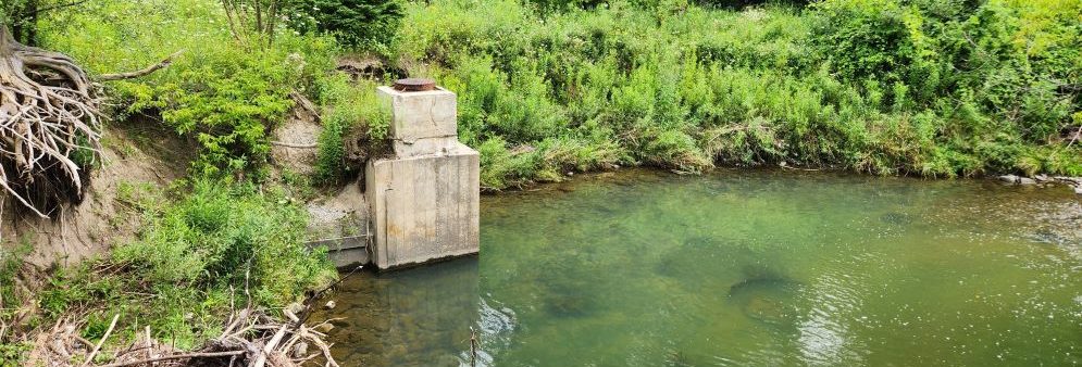
During storm events, rainwater or snow melt runoff enters underground pipes via drains and catch basins on streets and in parks and is discharged from storm sewer outfalls into watercourses that flow to Lake Ontario. At times these flows can be high, resulting in erosion damage. High flows from past storms have caused substantial erosion damage to sewers and watermains located in and near the City’s ravines and watercourses.
This erosion damage can:
To learn more about erosion in streams and rivers, view the Understanding Streams information slides.
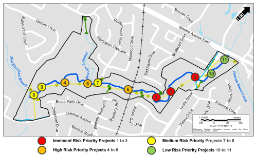
The map below shows the location of the German Mills Creek study area.

The study area is the two-kilometer length of German Mills Creek from Steeles Avenue East to where it meets the East Don River in the west.
While we aim to provide fully accessible content, there is no text alternative available for some of the content on this page. If you require alternate formats or need assistance understanding our maps, drawings or any other content, please contact us at 416-338-2985 or email germanmills@toronto.ca.
The purpose of the study was to develop a Geomorphic Systems Master Plan (GSMP) for German Mills Creek that includes recommendations for stabilizing the creek and protecting water infrastructure from erosion. Through the study, the City:
The study did not examine trail conditions or recommend improvements to trails, forestry or ravine amenities.
The study was carried out following the requirements of the Municipal Class Environmental Assessment (MCEA) Master Planning process, where the level of investigation, consultation and documentation are sufficient to fulfill the requirements for Schedule B projects identified within the Master Plan.
Steps in the MCEA study process
Following a successful review period the Master Plan will be complete. Projects identified within the Master Plan may proceed to detailed design and implementation and will be included in the City’s stream restoration and erosion control program. Implementation will be prioritized across all GSMPs city-wide.
The Master Plan report is shared with the City’s Parks, Forestry and Recreation division and TRCA for coordination and collaboration to advance a long-range plan for German Mills Creek.
The City will issue future notification prior to any construction.
The study area includes 56 City of Toronto water, stormwater and sanitary sewer infrastructure sites. The level of risk due to erosion was assessed for 43 water and stormwater sites. Based on the risk assessment, 11 priority project sites were identified for further evaluation as part of the study.
The level of risk caused by erosion is based on a technical assessment characterizing risk probability (time to exposure), existing bank protection, and risk severity, should damage occur.
Low risk sites
Medium risk sites
High risk sites
Imminent risk sites
The map below shows the 11 sites with at-risk infrastructure identified as priority projects.
The following alternative solutions for natural channel design were evaluated for infrastructure at-risk of erosion throughout the study area:
Alternative 1: Do nothing, no improvements
Alternative 2: Improvements through local works less than 200 metres
Alternative 3: Improvements through local works less that 200 metres and floodplain connections
Alternative 4: Improvements in a segment of the creek greater than 200 metres
Alternative solutions are evaluated per project, based on a range of criteria:
The following recommended solutions were made based on a risk assessment and evaluation of Alternative Solutions:
Future implementation of the recommended projects would require tree removal, followed by restoration and replanting with native trees and shrubs.
Project 1, 2, 3
Recommended solution: Local work less than 200 metres, with floodplain connections
The recommended solution for these projects:
Project 1 may require realignment of the pedestrian bridge located 500 metres west of Leslie Street to allow the stream to follow a natural course.
Projects 4, 5, 6, 7
Recommended solution: Local work less than 200 metres.
The recommended solution for these projects:
Projects 8, 9
Recommended solution: Local works less than 200 metres and floodplain connections
The recommended solution for these projects:
Project 10, 11
Recommended solution: Local works less than 200 metres
The recommended solution for these projects:
The study was carried out following the requirements for Master Plans under the Municipal Class Environmental Assessment process. A copy of the study report was made available for public review in 2025. See the German Mills Notice of Completion for details.
While we aim to provide fully accessible content, there is no text alternative available for the appendices on this page. If you require alternate formats or need assistance understanding our maps, drawings or any other content, please contact us at 416-338-2985 or germanmills@toronto.ca.
A public site walk and drop-in information was hosted on August 18, 2023. Members of the public were provided an overview of the study, had the opportunity to review recommended solutions and respond to questions and comments.
Consultation Materials