Shared lane markings will be added between Burnhamthorpe Road and Dundas Street West in July 2026. Construction at Martin Grove Road and Burnhamthorpe Road is now complete.
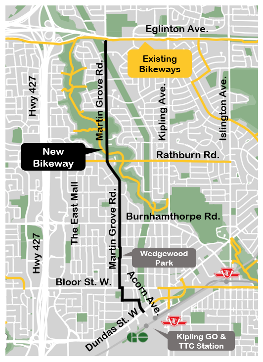
The City of Toronto is developing new cycling connections for existing on-street and off-street bikeways along Martin Grove Road between Eglinton Avenue West and the Kipling TTC and GO stations at Dundas Street West. Cycling connections will be installed in phases and includes opportunities to improve safety for pedestrians, people cycling and people driving.
News & Updates
December 2025
- City Council adopted staff recommendations to complete segments of the cycling connection between Burnhamthorpe Road and Dundas Street West. View the staff report at 2025.IE26.6.
November 2025
- As part of this project, Transportation Services reviewed opportunities for a new multi-use trail connection through Wedgewood Park, along with the other proposed street changes. Based on public feedback received in late summer 2025, staff have developed an alternative on-street route marked with shared lane markings (sharrows) that detours around the park on Swan Avenue, Charleston Road, and Rockfield Drive. South of the park, on Martin Grove Road from Rockfield Drive to Bloor Street West, shared lane markings (sharrows) are recommended, with no changes to on-street parking or travel lanes.
August 2025
- Based on community feedback received through public consultation in 2022, the design for a cycling connection on Martin Grove Road has been updated for the segment from Burnhamthorpe Road to the Bloor Street intersection including the multi-use trail through Wedgewood Park.
- City staff are preparing to bring the completion of the Martin Grove Cycling Connections project to the Infrastructure and Environment Committee in Fall 2025. Implementation is planned in phases through 2025 and 2026.
- Changes for the Martin Grove Road and Burnhamthorpe Road intersection, approved in 2022, are planned for implementation in Fall 2025. The changes will improve safety for all road users by extending the bike lane to the intersection, increasing sidewalk space and reducing the crossing distance for pedestrians. Traffic lanes remain the same.
City Staff were on site at Wedgewood Park on Tuesday September 9, 2025 to share information about the new multi-use trail design.
July 2022
- City Council approved changes to Martin Grove Road between Eglinton Avenue West and Burnhamthorpe Road. A copy of the staff report is available under IEC agenda item IE 31.12.
- In response to public feedback the segment south of Burnhamthorpe Road to Bloor Street West will be reviewed.
- Changes between Eglinton Avenue West and Winterton Drive will be coordinated with Metrolinx for delivery with the Eglinton West LRT construction expected between 2025 and 2030.
Project Area
The project area is along Martin Grove Road from Eglinton Avenue West to Dundas Street West.

Response to Feedback 2025
In response to feedback received through public consultation, the design for cycling connections from Burnhamthorpe Road to Bloor Street West has been revised from the proposed changes that were presented in 2022.
Burnhamthorpe Road to Wedgewood Park
- Shared lane markings (sharrows) to identify shared space with motor vehicles and people cycling.
- No changes to traffic operations.
- No changes to on-street parking.
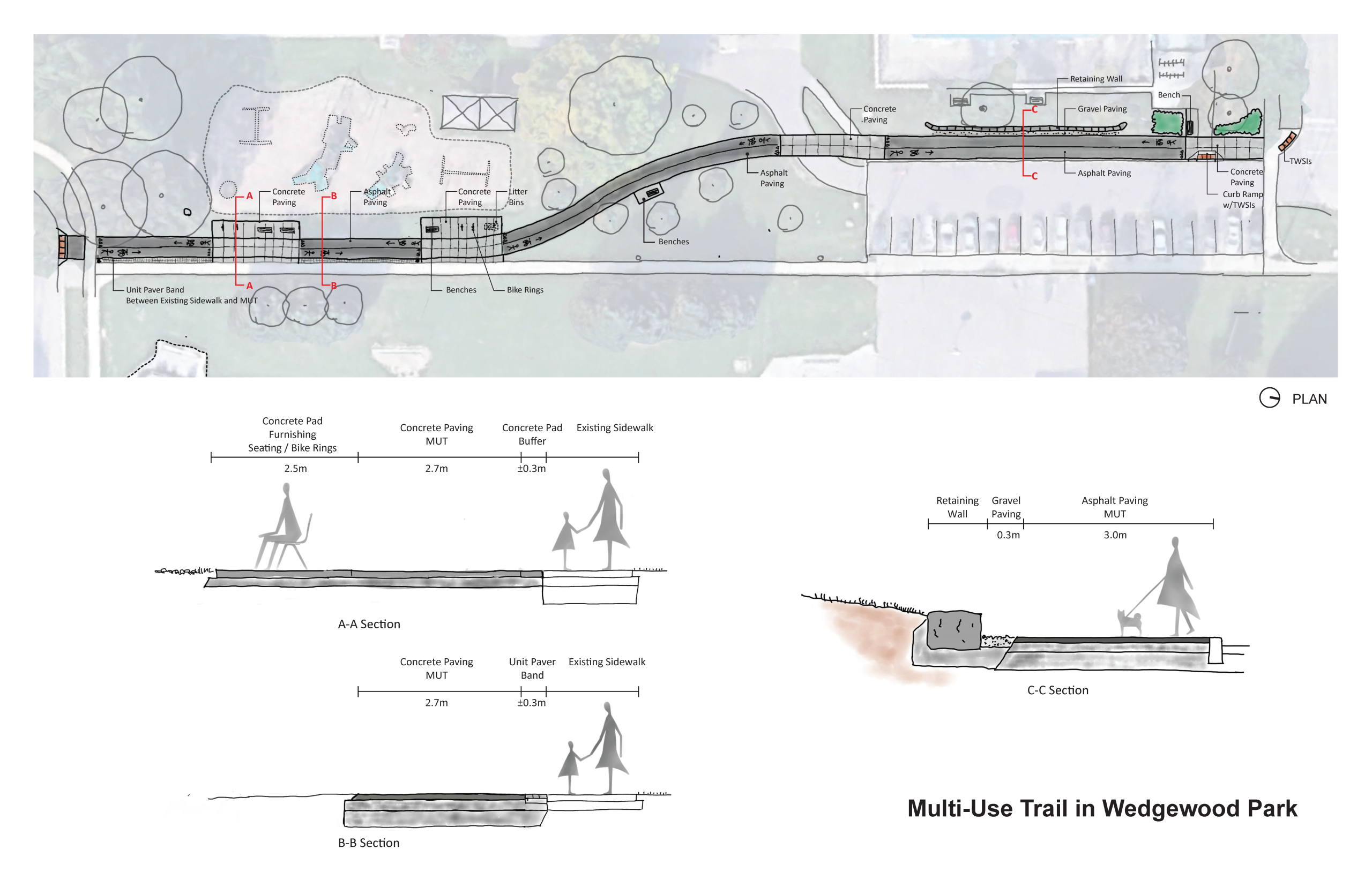
Wedgewood Park Multi-use Trail
- New multi-use trail through Wedgewood Park, west of existing sidewalk.
- New landscaping features will create a greater distinction between the playground and the multi-use trail including relocated benches and new bike rings. Textured concrete will identify transition areas near the playground where people should use caution when proceeding.
- The new trail will be clearly marked with painted symbols and signage to remind users that it is a shared space for people walking and cycling, and that cyclists should yield to pedestrians.
- A small number of trees will be impacted, and replanting will occur in a nearby location.
- No impacts to existing parking lot or access.
- The existing sidewalk will remain unchanged.

City Staff were on site at Wedgewood Park on Tuesday September 9, 2025 from 2:30 p.m. to 5:00 p.m. to share information about the new multi-use trail design. In response to feedback staff have proceeded with an alternative on-street route marked with shared lane markings (sharrows) that detours around the park.
Wedgewood Park to Bloor Street West
- Shared lane markings (sharrows) to identify shared space with motor vehicles and people cycling.
- No changes to traffic operations.
- No changes to on-street parking.
Bloor Street West Intersection Improvements
- New two-way raised cycle track with integrated accessible TTC transit stop on the north side between Martin Grove Road and Wilmar Road.
- No change to traffic lanes.
- New curb extension on the southwest corner to reduce pedestrian crossing distance and provide space for an improved transit stop with shelter.
- Reduced curb radii at all corners for better visibility between road users
- New tactile surface indicators.
In response to public feedback the originally proposed left-turn calming hump has been removed.
Bloor Street West to Dundas Street West: Wilmar Road, Montesson Street, and Acorn Avenue
- Shared lane markings (sharrows) to identify shared space with motor vehicles and people on bike.
- No changes to traffic patterns.
- No changes to on-street parking.
Approved Changes 2022
Eglinton Avenue West to Winterton Drive
- Uni-directional cycle tracks, along Martin Grove Road with improved bus stops and accessibility elements.
- A protected intersection at Martin Grove Road and Eglinton Avenue West.
- Existing motor vehicle lanes are maintained, but narrowed to accommodate changes.
Burnhamthorpe Road Intersection
- New bicycle lanes from 92 m north of Burnhamthorpe Road to 50 m south Burnhamthorpe Road to connect with the existing bicycle lanes on Martin Grove Road from Rathburn Road.
- The removal of the parking lay-by on the west side of Martin Grove Road, north of Burnhamthorpe Road.
- Relocation of the northside westbound TTC bus stop form the west side of Martin Grove Road to the east side of Martin Grove Road, including the removal of the bus-bay, replacing it with green infrastructure.
- New curb extensions on the northwest corner to provide additional space for pedestrians.
Public Consultation
Public consultation took place between April 24 and May 18, 2022, including stakeholder engagement, an online survey, and a virtual public meeting.
Project Materials
Date modified: July 14, 2026