The REimagining Yonge public review of the Environmental Study Report is now complete. The next steps include developing detailed designs and obtaining permits and approvals. The City will continue to engage the public in the next steps.
Yonge Street is the central corridor within North York Centre, one of four mixed-use and transit-accessible centres identified in the Official Plan where jobs, housing and services will be concentrated. The City of Toronto will evaluate opportunities to improve the streetscape and public realm for all users (people cycling, using transit, driving and pedestrians) along Yonge Street from Sheppard Avenue to the Finch Hydro Corridor.
On December 16, 2020, City endorsed the recommended design for the reconstruction of Yonge Street between Florence Avenue/Avondale Avenue to the Finch Hydro Corridor.
The preferred design concept for Yonge Street, includes:
Detailed Design: Tentatively expected to start in 2025
Construction: Tentatively expected to start in 2028
The study has been carried out under Schedule ‘C’ of the Municipal Class Environmental Assessment (EA), which is an approved planning process under the Ontario Environmental Assessment Act. An Environmental Study Report was placed on the public record for a 30-day review period, starting March 24 and ending on April 22, 2022.
Table of Contents and Executive Summary
Chapter 2 – Problems and Opportunities
Chapter 3 – Existing Conditions (part 1)
Chapter 3 – Existing Conditions (part 2)
Chapter 4 – Consultation and Engagement
Chapter 5 – Evaluation of Alternatives
Appendices:
Appendix A – Natural Environment
Appendix C – Air Quality Assessment
Appendix E – Stage 1 Archaeological Assessment Report
Appendix G – Traffic Analysis and Modelling Summaries
Appendix H – Public Consultation Record
Appendix I – Stakeholder Consultation Record
Appendix J – Indigenous Community Engagement Record
Appendix K – Re-Imagine Yonge-Layout 30% design (part 1)
Appendix K – Re-Imagine Yonge-Layout 30% design (part 2)
Appendix K – Re-Imagine Yonge-Layout 30% design (part 3)
Appendix K – Re-Imagine Yonge-Layout 30% design (part 4)
While we aim to provide fully accessible content, there is no text alternative available for some of the content on this site. If you require alternative formats or need assistance understanding our maps, drawings or other content, please contact us at reimaginingyonge@toronto.ca or 416-392-2990.
Yonge Street is the central transportation corridor and pedestrian promenade within North York Centre, one of four centres that have an important role in achieving the provincial growth objectives of the Official Plan where jobs, housing, and services will be concentrated. While the North York Centre is transforming into a transit-oriented and dynamic mixed-use area, the implementation of the street vision has not been fully achieved or kept pace with this evolution. Inconsistent urban design features, including sidewalks, crossings, and medians, and the lack of dedicated cycling facilities reduce the appeal of the street and present transportation challenges. The City of Toronto is carrying out a study that will evaluate opportunities to improve the streetscape and public realm for all users (pedestrians, cyclists, transit and vehicles) along Yonge Street from Sheppard Avenue to the Finch Hydro Corridor. A number of opportunities will be considered, including:
The study is being carried out under Schedule ‘C’ of the Municipal Class Environmental Assessment (EA), which is an approved planning process under the Ontario Environmental Assessment Act. The public will have opportunities for input at key stages of this study. The study will define the problem, develop and evaluate alternative solutions, review public and stakeholder feedback, and identify measures to minimize any impacts.
An Environmental Study Report will be prepared at the end of the process in accordance with the requirements of the Municipal Class EA.
Thanks to all who attended the fourth Public Drop-in Event on December 11th, 2017. You can view the notice for more information.
If you were unable to attend the event, you can view the display panels.
Thanks to all who attended the fourth Public Drop-in Event on October 10th, 2017.
If you were unable to attend the event, you can view the display panels.
You can also review the roll plans of the Stage 2 alternatives:
Thanks to all who attended the fourth Public Drop-in Event on September 19th, 2017. You can view the notice for more information.
If you were unable to attend the event, you can view the display panels.
You can view the roll plans here:
Thank you to everyone who attended the July 25, 2016 Public Drop-in Event, held from 11:00am – 2:00pm in Mel Lastman Square, and from 5:00pm – 8:00pm in Memorial Hall. You can view the notice for more information.
If you were unable to attend the event, you can view the display panels.
Thank you to everyone who attended the June 9 & 11, 2016 Design Charrette and collaborated with the project team on identifying a preferred alternative solution and developing design options for Yonge Street. You can view the notice.
Thank you to everyone who attended the May 25, 2016 Drop-in Event at Memorial Hall. You can view the notice.
If you were unable to attend the event, you can view the display panels.
Thank you to everyone who attended our Jane’s Walk on Saturday, May 7, 2016. Our group started at Mel Lastman Square and walked along Yonge Street to discuss the history of the area, current conditions, and plans for improvements.
Yonge Street is the central transportation corridor and pedestrian promenade within North York Centre. Under the provincial Growth Plan for the Greater Golden Horseshoe, the North York Centre is identified as an urban growth centre. While this area is transforming into a transit-oriented and dynamic mixed-use area, the implementation of the street vision has not been fully achieved or kept pace with this evolution. Today the area is faced with challenges from inconsistent features such as sidewalks, pedestrian crossing and medians to lack of dedicated cycling facilities and concerns over traffic movement.
Over the past few years, the City has completed work on Yonge Street related to upgrading the underground services (i.e. watermains). However, the overall surface condition on Yonge Street (ie. pavement, sidewalks) requires significant investment to maintain a state of good repair.
This study provides an opportunity to create an attractive and consistent streetscape with design appropriate to the civic goals of the North York Centre that will serve people of all ages as they travel in and around the area for work, school and leisure.
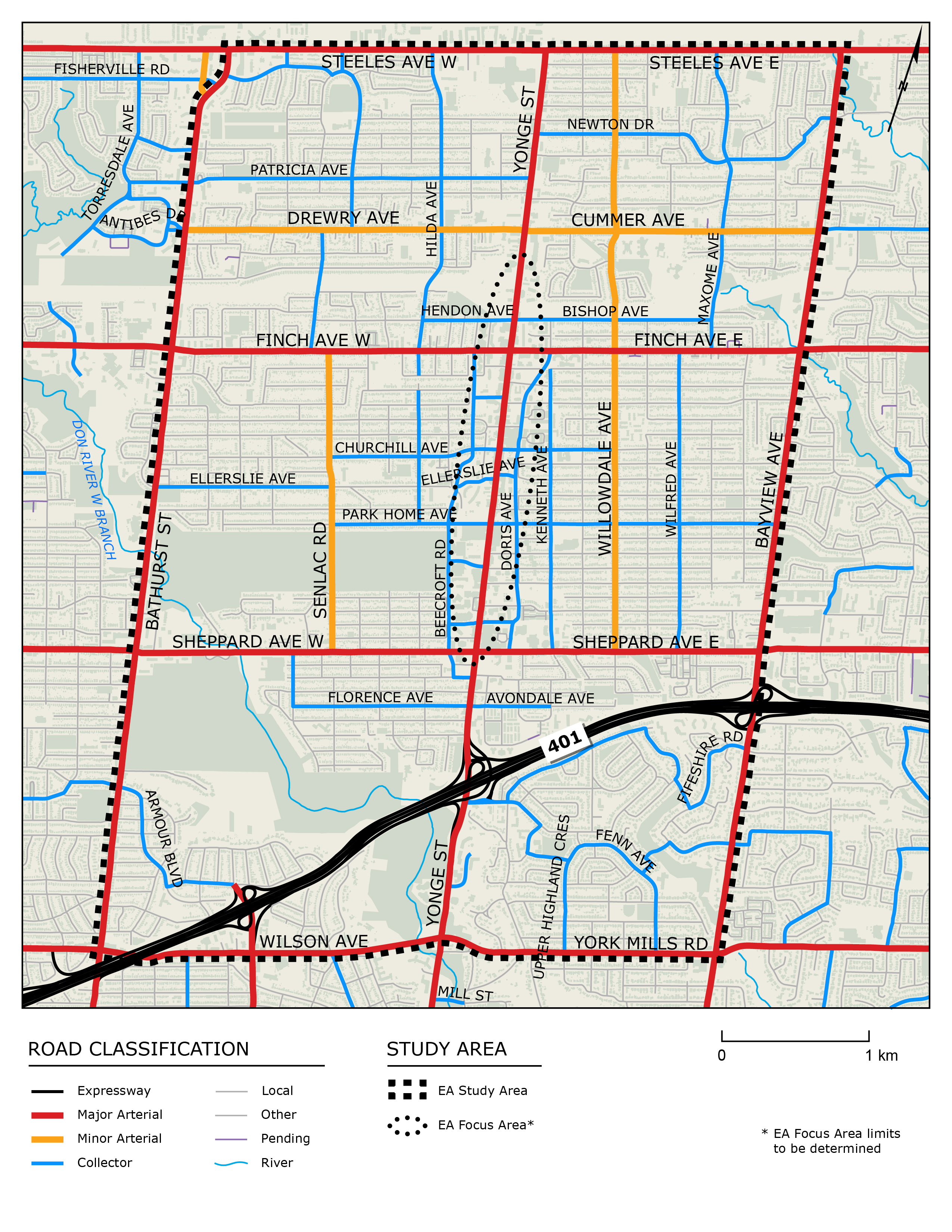
The focussed study area consists of Yonge Street from south of Sheppard Avenue (Avondale Avenue and Florence Avenue) to north of Finch Avenue (the Finch Hydro Corridor), Doris Avenue to the east and Beecroft Road to the west. A larger study area, extending from Bathurst Street to Bayview Avenue, and Wilson Avenue and York Mills Road to Steeles Avenue, is being addressed as well, primarily in terms of potential traffic impacts. This larger study area also defines the consultation area.
In February 2017, City Council directed that further review be undertaken to assess the installation of cycling facilities on Doris Avenue and/or Beecroft Road, rather than on Yonge Street. Beecroft Road and Doris Avenue were created as service roads to provide an alternate route to Yonge Street. Bike lanes were considered previously on these streets, and the City concluded that there was not adequate space for dedicated bike lanes/cycling facilities on these streets. Reconstruction and acquisition of property would be required as well, adding to the cost and complexity.
In May 2017, the Public Works and Infrastructure Committee adopted a recommendation to complete an additional phase of design work which includes a comprehensive review of options to implement cycling facilities on Doris Avenue and/or Beecroft Road and Willowdale Avenue from Bishop Avenue to Steeles Avenue. Additional stakeholder consultation will be a key component of this next phase, including consultation with the local business community.
Staff had previously reviewed the feasibility of implementing bicycle lanes on Doris Avenue and Beecroft Road, but had only assessed options that would accommodate painted bicycle lanes within the existing pavement width of these roads, without impacting the number of travel lanes. Accommodating bicycle lanes on both Doris Avenue and/or Beecroft Road could be possible through widening of the existing pavement width, relocation of curbs, and/or the removal of travel lanes.
In accordance with direction from City Council in February 2017 and Public Works and Infrastructure Committee in May 2017, a more comprehensive review of options to implement cycling facilities on Doris Avenue and/or Beecroft Road will be completed as part of the next phase of work.
There are unresolved concerns about certain elements of the preliminary preferred alternative including potential impacts to traffic capacity on Yonge Street and to on-street parking, and the need for wider consultation on the project, particularly with local businesses.
The next phase of work will include the following:
The City will be investigating another option on Yonge Street that would meet the project objectives but not reduce the number of lanes on Yonge Street. Additional work will be undertaken to develop this alternative, understand the costs and benefits, and seek public input on it before reporting back to Public Works and Infrastructure Committee and City Council.
It is anticipated that a report would be brought forward to the Public Works and Infrastructure Committee in the fourth quarter of 2017 with the outcome of this work.
Funding for capital construction, municipal servicing and utility relocations is currently not available within the 2017-2026 Approved Capital Budget and Plan for Transportation Services. Opportunities to secure funding through the development review process, particularly as it relates to streetscape costs, are being pursued. Funding for this project would be considered against other unfunded City priorities as part of a future capital budget process. The detailed design stage of this work could be advanced through leveraging the $2.0 million of available Public Transit Infrastructure Funds (PTIF) for detailed design beginning in 2017.
The northern limit does not extend to Steeles Avenue because of the different character (e.g. lack of subway, less retail, higher volumes of bus traffic, etc…) of Yonge Street north of Finch Avenue. In addition, the area north of Finch is subject to a different Secondary Plan. A separate “Phase 2” study will be undertaken to examine potential changes to the section of Yonge Street from Finch Avenue to Steeles Avenue. It is anticipated that this will be initiated in 2017.
The study is being carried out in accordance with the requirements of the Municipal Class Environmental Assessment, which is an approved planning and decision-making process under the Environmental Assessment Act that is used to assess changes to public infrastructure.
The process includes identifying the problem or opportunity to be addressed, developing and evaluating a range of alternative solutions, identifying a preliminary preferred solution, evaluating design options for the preferred solution and selecting a preferred design option.
The study is being completed as a Schedule ‘C’ undertaking, which generally includes the construction of new facilities and major expansions to existing facilities. The public will have opportunities for input at key stages of the study.
Input can be provided to the Project Team at any time throughout the study by phone, mail, fax, email, or by attending one of the consultation events. We have provided multiple opportunities for input.
The new phase of work will provide opportunities for public and stakeholder engagement.
Kate Nelischer is the City’s Senior Public Consultation Coordinator for the project and can be reached by email at knelischer@toronto.ca or phone 416-392-4360.
As indicated above, the City is undertaking a new phase of design work. Two Public Drop-in Events (#4 and #5) are included in this new phase of study. Notices will distributed to all property owners within the study area, posted online on the project webpage, printed in the North York Mirror (East), and sent to the project email list.
Construction timing is contingent on availability of funding from Council, receiving the necessary planning approvals/permits and completion of the detail design study.
The property impacts associated with the new design alternatives will be considered as part of the additional phase of study. Should property impacts be identified, these impacts will be weighed against the relative advantages and disadvantages of each alternative considered.
Design options developed include consideration of all modes of transportation. The preferred design option has not been selected, but we welcome your input about different modes of transportation along Yonge Street, Beecroft Road, Doris Avenue and other streets within the Study Focus Area.
The City’s public right-of-way extends from adjoining property lines and includes Yonge Street, the sidewalks and public boulevards. Reconfiguring the right-of-way is being considered to accommodate other elements, such as dedicated bike facilities, wider sidewalks and street trees. These changes are consistent with the application of a Complete Streets approach to accommodating all modes of transportation and have the potential to enhance Yonge Street as a better public space. The City is continuing to review alternatives for Yonge Street.
The preliminary preferred alternative includes a reduction of travel lanes from 6 to 4 between Sheppard Avenue and Hendon Avenue / Bishop Avenue. However, given the unresolved concerns about certain elements of the preliminary preferred alternative, the City is continuing the Environmental Assessment Study to investigate another option on Yonge Street that would meet the project objectives but not reduce the number of lanes on Yonge Street.
A transportation simulation model is being completed to assess the existing and future transportation needs along Yonge Street, Beecroft Road and Doris Avenue.
The study is reviewing existing pedestrian crossing locations along Yonge Street, and will review existing pedestrian movements and collision data. The study will consider the feasibility of adding more controlled crossing opportunities along Yonge Street.
This study is on hold pending further discussions with MTO.
The City is recommending “Option B” as identified in the North York Centre South Service Road Environmental Assessment Addendum Study. The preferred option includes an extension of Doris Avenue south of Sheppard Avenue East to connect with Tradewind Avenue. The extension would form a single continuous intersection with Sheppard Avenue East and result in the conversion of Bonnington Place, north of Lyndale Drive, to a cul-de-sac. Completion of the Doris Avenue/South Service Road Extension will be informed by the completion of the additional phase of work for the REimagining Yonge study.
The preliminary preferred alternative was presented at the third Public Open House on September 29, 2016. A recommended plan for the proposed new phase of study will be presented in the fourth quarter of 2017.
Representatives within the City are working together to review the status of active development applications within the study area. The City will meet with local developers to ensure that all planned construction work is coordinated to the extent possible.
Public realm is defined as any publicly owned streets, pathways, right of ways, parks, publicly accessible open spaces and any public and civic building and facilities. Enhancing the public realm is a key aspect of the project.
The work completed over the past few years has been related to upgrading the underground services (i.e. watermains) and maintaining the overall state of good repair.
Despite this work, Yonge Street continues to be faced with challenges from inconsistent features such as sidewalks, pedestrian crossings and medians to lack of dedicated cycling facilities and concerns over traffic movement.
The City is looking at ways to create an attractive and consistent streetscape with design appropriate to the civic goals of the North York Centre that will serve people of all ages as they travel in and around the area for work, school and leisure.
A full reconstruction of the street is expected to be required in the next few years and this project takes advantage of an opportunity to enhance the road and public realm at the same time the road is reconstructed.
Reconstruction of the road will result in the relocation of some underground utilities, while others may need to be adjusted slightly. As part of the City’s study, the Project Team is meeting with utility companies and local developers to ensure that any utility work is coordinated.
The City has undertaken a subsurface utility engineering investigation on Yonge Street from Florence Ave./Avondale Ave. to the Finch Hydro Corridor to confirm the existing underground infrastructure (ie. watermains and sewers). Additional subsurface utility engineering investigations will be completed as part of the next phase of study.
Yes, the City is planning to connect the trail along the Hydro Corridor to Yonge Street. Discussions with TTC and others are ongoing.
Once reconstruction of the road has been completed, the City will be committed to maintaining it. One of the criteria used to evaluate the design options is maintenance/operational costs and this will be carefully considered as part of the recommended plan that is presented to City Council.
The project team consists of City staff who will ultimately be responsible for maintaining Yonge Street and have a strong understanding of the maintenance/operational costs associated with each of the design options. In addition, the City is meeting with utility companies and local developers to ensure that any planned subsurface work is coordinated with this project.
Cost is one of many criteria that will be used to evaluate the design options. However, it will not be the deciding factor as other criteria will also be used to evaluate the design options (ie. impacts on cycling and walking, accessibility, natural environment, etc.). The construction schedule will be determined during the detailed design phase and as such, the budget estimate will be refined at that time.
Funding for this project will be requested through the City’s capital budget process. A specific tax levy for this project is not contemplated.