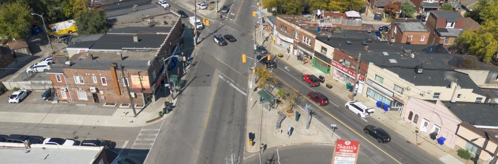
The City of Toronto is inviting residents to learn more and provide feedback on road safety upgrades and opportunities to make changes to cycling, pedestrian, and motor vehicle operations on Vaughan Road, Wychwood Avenue, Arlington Avenue, Robina Avenue, Hursting Avenue and Maplewood Avenue. Proposed road safety upgrades include the addition of bikeways, intersection safety improvements and signal upgrades, parking changes, directional changes and streetscaping enhancements.
Road resurfacing is planned for 2028 on Vaughan Road, presenting an opportunity to make needed road safety changes and implement sections of the City’s Cycling Network Plan in the near future.
Public feedback, along with technical considerations and City policies and guidelines will be considered in decisions to be made by staff and City Council.
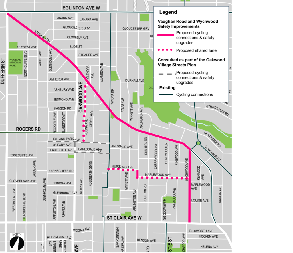
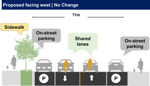
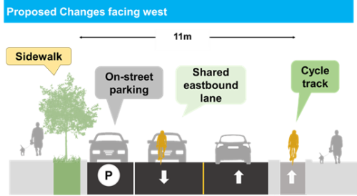
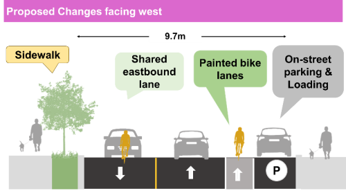
The City is proposing to upgrade the existing bike lane to a cycle track in the westbound direction and add a shared lane (‘sharrows’) in the eastbound direction. A cycle track would include physical separation between motor vehicle travel lanes and the bicycle lane, making cycling safer for people of all ages and abilities.
The design of the cycle track varies by block between Dufferin Street and Wychwood Avenue:


Other proposed changes include:
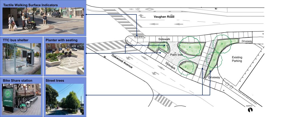
The City is proposing intersection safety and accessibility improvements and opportunities for streetscaping and placemaking.
Proposed changes include:
Parking changes are proposed on Vaughan Road to manage speeding and to accommodate the installation of the cycle track, intersection safety improvements, and the proposed traffic signal at Vaughan Road and Wychwood Avenue.
Proposed changes to parking include:
Northcliffe Boulevard to Oakwood Avenue
Oakwood Avenue to Glenora Avenue
Arlington Avenue to Rushton Road (permit area 13F)
Rushton Road to Wychwood Avenue (permit area 13F)
On Connaught Circle between Vaughan Road and Claxton Boulevard (permit area 13F) 2 on-street parking spaces would be removed.
The City is exploring future opportunities to expand the 13F permit area to offset the reduction in parking on Vaughan Road and offer more parking opportunities to permit holders .
March 2026 Update: The City has a revised proposal for this section, which would move all parking to the east side of Wychwood Avenue. Please see the Public Consultation tab for more information.
The City is proposing to install a contra-flow bikeway on Wychwood Avenue south of Vaughan Road. A contra-flow bikeway allows people cycling to travel in the opposite direction of traffic. Proposed changes include:

In this section the City is proposing the following changes:
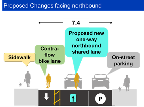
Changes are proposed at the Wychwood Avenue and St. Clair Avenue West intersection to address dangerous vehicle maneuvers and improve safety for all road users. It is proposed to convert the direction of traffic on Wychwood Avenue to one-way northbound between St. Clair Avenue West and Louise Avenue to address safety concerns related to those vehicle movements and to allow people cycling to travel northbound/southbound.
Other proposed changes include:
The City is proposing to install a contra-flow bikeway to provide a safe cycling connection in both directions between proposed shared lanes on Hursting Avenue and Maplewood Avenue.
Proposed changes include:

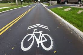
Shared lane markings are proposed to provide a safer alternative to Vaughan Road for people cycling eastbound. Shared lane markings indicate a shared environment for bicycles and motor vehicles and alert all road users to the presence of bicycle traffic on the street.
Shared lanes do not require changes to the operation of the road or on-street parking.
Shared lanes are proposed on the following streets that have two-way traffic:
Following public feedback, the City of Toronto has revised the proposed design for Wychwood Avenue.
A virtual Public Meeting was held on March 12, 2026 that included a presentation and Question & Answer period. View the presentation below.
Feedback
Complete the online survey before March 26. Contact us to request a printed copy of the survey.
Please review the consultation materials below before completing the survey.
Consultation Materials
The comment period for this consultation has closed. The Public Consultation Report summarizes feedback received.
The November 13, 2025 Public Drop-In Event was held at the Rawlinson Community School Gymnasium and provided an opportunity to view the project information panels and speak with members of the project team one-on-one.
Vaughan Road and Wychwood Avenue have been identified in the City Council-approved 2025-2027 Cycling Network Near Term Implementation Plan. Changes to these streets, along with changes on Arlington Avenue would connect gaps in the network and connect people to destinations including schools, community amenities and transit.
Changes on these streets would support the City’s commitment to the Vision Zero Road Safety Plan. The Plan’s goal is to eliminate traffic-related fatalities and serious injuries by making our roads safer for everyone, especially for seniors, school children, and people walking and cycling. From 2015 to 2025, there were 459 vehicle collisions on Vaughan Road between Dufferin Street and Wychwood Avenue, resulting in five people killed or seriously injured, including two pedestrians. Over the same period, there were 89 collisions on Wychwood Avenue between Vaughan Road and St. Clair Avenue West. All proposed changes are focused on improving road safety.
The proposed bikeway on Vaughan Road is supported by the Oakwood Village Streets Plan, which considers the needs of all road users and emphasizes the safety of vulnerable road users such as seniors, school children, and people walking and cycling. The Streets Plan was initiated in 2024 to identify, prioritize and recommend short-term actions and long-term changes to traffic operations and road design to support safety for all modes of transportation in the Oakwood Village neighbourhood. One of the top concerns and opportunities identified through public feedback is to support better travel options without a car.
Additionally, in 2028 road resurfacing is planned on Vaughan Road between Oakwood Avenue and Winnett Drive. Making safety improvements with planned road work is cost effective and minimizes disruption in the community.
Bikeway Design Considerations
In response to community concerns around proposed bikeway designs, the following provides clarification on the three bikeway types included in the design proposal.
Wychwood Avenue; Arlington Avenue
Vaughan Road
Hursting Avenue, Maplewood Avenue
Traffic Signal and Pedestrian Safety Considerations on Vaughan Road
It is proposed to install traffic signals at Vaughan Road and Wychwood Avenue to allow a safe crossing for pedestrians and people cycling across Vaughan Road and the Glencedar Bridge. The signal would be located 180 metres away from existing signals at Vaughan Road and Kenwood Avenue. The two signals would be coordinated to prioritize traffic flow.
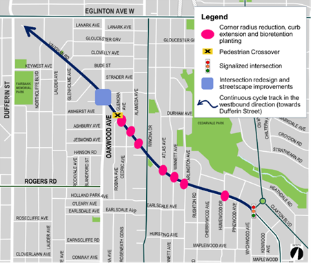
Additional concrete bump-outs and/or bio-retention planters are proposed to narrow pedestrian crossings and slow motor vehicle turning movements to and from Vaughan Road at Glenora Avenue, Robina Avenue, Alameda Avenue, Cedric Avenue, Jesmond Avenue, Atlas Avenue, Winnett Avenue, Arlington Avenue, and Wychwood Avenue. Details of these proposed curb extensions are shown in pink on the project’s roll plans.
It is not proposed to install a formalized crossing at Vaughan Road and Atlas Avenue nor upgrade the pedestrian crossover at Vaughan Road and Arlington Avenue to a signalized intersection at this time. Proposed curb extensions would provide greater safety for pedestrians by narrowing crossings and enforcing slower turns for motor vehicles. Further safety opportunities will continue to be explored through the detailed design process.
Parking Considerations
The project proposes parking changes on Vaughan Road to manage speeding and the installation of the cycle track, intersection safety improvements and the proposed traffic signal at Vaughan Road and Wychwood Avenue.
On Vaughan Road between Dufferin Street and Winona Drive, there is no proposed change to pay-and-display parking, providing customers with parking to support local businesses. It is proposed to remove 12 permit-specific parking spaces in this section of Vaughan Road. There are currently 99 parking spaces and 50 issued permits in this section, so there is enough supply of on-street parking to accommodate this reduction. Some parking/ loading opportunities will remain available on the north side of Vaughan Road, east of Oakwood Avenue.
In permit area 13F, there would be an overall reduction of 3 spaces on Vaughan Road and 2 spaces on Connaught Circle. There is enough support of on-street parking to accommodate the reduction of 5 spaces, but when uptake exceeds 90%, the City would monitor closely the issuance of new permits.
Overall, there are minor impacts to parking supply on Vaughan Road. On Wychwood Avenue, a revised proposal will include parking on the east side of the street that has more ample parking opportunities than on the west side as previously presented.
To receive project updates by email, please email us at vaughanwychwood@toronto.ca and indicate that you would like to be added to the mailing list.