The City is improving cycling infrastructure near the York University Keele Campus and in the Downsview Neighbourhood. This will provide bike connections to Downsview Park, the Black Creek Ravine system and major transit stops and stations on TTC Line 1 and the future Finch LRT. In June 2018, Toronto City Council approved the installation of the proposed cycling routes for the York University and Downsview Cycling Connections project. The next steps will see the installation of the cycling facilities in stages. Installation began in August 2018 and will continue through 2023. Please refer to the tabs below for the latest information.

Council April 7, 2022 – Item IE28.7

City Council has authorized the installation of Sentinel Road Safety Improvements project.

City Council has requested Transportation Services to, as part of the next Near-Term Cycling Network Plan Update, review opportunities for a connection along the south side of Sheppard Avenue West from Sunfield Road and up to the east terminus of the future multi-use trail.

City Council has also requested Transportation Services to report to the next meeting of the Infrastructure and Environment Committee on a plan for extending the Sentinel Road Safety Improvements project, north to Finch Avenue, and subsequently to Pond Road as a second phase.

You can watch the video of City Council meeting from the Toronto City Council and Committees web page or the City of Toronto’s YouTube channel.

IEC Endorses Staff Report

On March 29, 2022, Infrastructure and Environment Committee (IEC) endorsed IE 28.7 – staff recommendations with amendments to authorize the installation of the Sentinel Road Safety Improvements project.

Virtual Public Meeting

A Virtual Public Meeting was held on Wednesday, February 9, 2022.

Project Materials

Project Details

Artistic rendering of raised cycle track at Lamberton Blv - Elia School

The proposed changes on Sentinel Road are guided by the City’s Vision Zero Road Safety Plan. The plan is focused on eliminating traffic-related fatalities and serious injuries by making our roads safer for everyone, especially vulnerable road users such as seniors, school children, and people walking and cycling. From 2016 to 2020, 114 vehicle collisions occurred on Sentinel Road between Lamberton Boulevard and Sheppard Avenue West.

Why Consider Changes on Sentinel Road?

The City of Toronto is proposing changes on Sentinel Road as part of the road reconstruction to fulfill the City’s commitment the Vision Zero Road Safety Plan. The Plan’s goal is to eliminate traffic-related fatalities and serious injuries by making our roads safer for everyone, especially for seniors, school children, and people walking and cycling. From 2016 to 2020, there were 114 vehicle collisions on Sentinel Road between Lamberton Boulevard and Sheppard Avenue West. All proposed changes are focused on reducing future collisions.

Proposed Changes

Improvements for walking and cycling

  • Sidewalks would be widened, where feasible
  • Pedestrian crossings would be improved and made accessible
  • Raised crosswalks would be installed at all intersections from Lamberton Boulevard to Streamdale Court/Brookwell Drive, except Grandravine Drive
  • Raised cycle tracks would be added to both sides of the street
  • Bus stops would be integrated with the raised cycle tracks

Improvements for driving

  • There are limited proposed changes to the street for people driving. One vehicle lane in each direction would be maintained and traffic calming including raised crosswalks and changes in intersection curb radii would be installed

Impacts to public space and green features

  • Some trees will be impacted to accommodate the road safety changes. Some trees will need to be replanted due to limiting conditions (e.g. hydro lines above) or removed to accommodate the proposed changes
  • Additional trees will be planted to result in a net increase of trees in the area

From July 2021 to April 2022, the City of Toronto will be constructing new multi-use pathways and dedicated bikeways in the York University area.

For more information, please see the project design and construction notice below:

Map showing the project location on Murray Ross Parkway, Evelyn Wiggins Drive and Keele Street.

From September 2021 to May 2022, the City of Toronto will be constructing sidewalks, bike lanes, and multi-use trails in the Downsview area.

For more information, please see the construction notice below:

Map showing the project location where there will be pavement markings and intersection construction.


The City’s Council-approved Cycling Network Ten-Year Plan identifies existing, planned, and proposed cycling facilities across Toronto. The City is installing a number of new cycling routes in both neighbourhoods, including bike lanes, sharrows, and boulevard trails.

The York University routes include

  • Cycle tracks on:
    • Shoreham Drive (from Jane Street to the Pond Road)
    • Evelyn Wiggins Drive (including a curb cut to connect cyclists to the adjacent trail that runs west of the Busway, from Evelyn Wiggins Drive to the Pond Road)
  • A boulevard trail on Murray Ross Parkway (from Shoreham Drive to Steeles Avenue W.)
  • Improved connections to the Black Creek Ravine
  • An extension of the sharrows on the Pond Road
  • Safety improvements to existing bike lanes on Sentinel Road

The Downsview Neighbourhood routes include

  • Shared lanes (‘sharrows’) on:
    • Yorkwoods Gate
    • London Green Court
    • Camborne Avenue
    • Sunfield Road
    • Maryport Avenue
    • Langholm Drive
    • Stilecroft Drive
  • Bike lanes on:
    • Dovehouse Avenue (bike lane on south side of street; shared lane on north side of street)
    • Sentinel Road (including a small stretch of shared lane)
    • Sheppard Ave (60m boulevard trail between Sentinel and Sunfield)

Public Consultation

The City hosted three public drop-in events for this project in Winter 2018. You can find more information in the public consultation report below:

Past Construction Notices

Impacts to public space and green features on Sentinel Road

Some trees will be impacted to accommodate the road safety changes. Some trees will require replanted due to limiting conditions (e.g. hydro lines above) or removed to accommodate the proposed changes. Additional trees would be planted to result in a net increase of trees in the area, compared to the 151 trees today.

Proposed changes to trees on Sentinel Road:

Preserved 115-120
Removed 26-31
Planted 42-51
Net 157-171

Why is the City proposing new cycling facilities?

These majority of these cycling facilities were included in the Cycling Network Ten-Year Plan to improve the cycling infrastructure in York University Keele Campus and the Downsview Neighbourhood. This infrastructure will provide connections to Downsview Park, the Black Creek Ravine system and major transit stops along Line 1 and the Finch LRT.
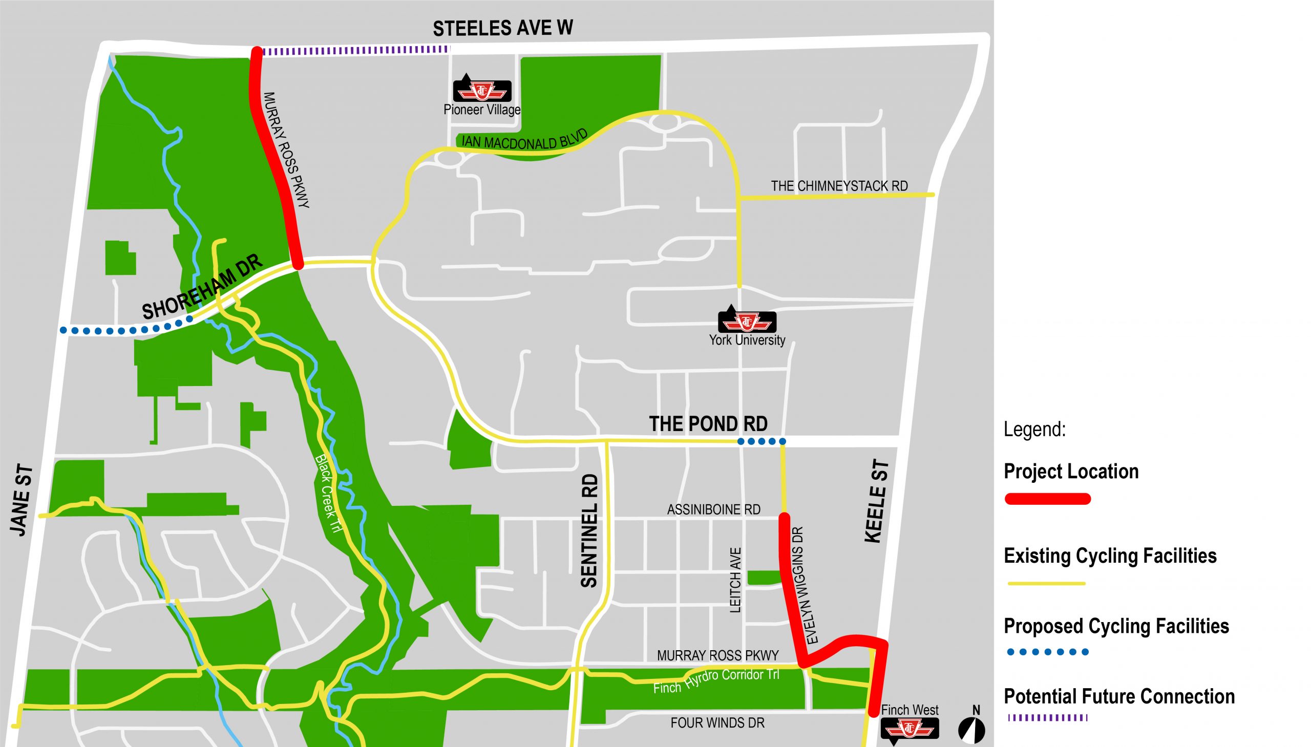
What are the project boundaries?

The study area for the York University cycling facilities is bounded by Steeles Avenue West, Jane Street, Finch Avenue West, and Keele Street.
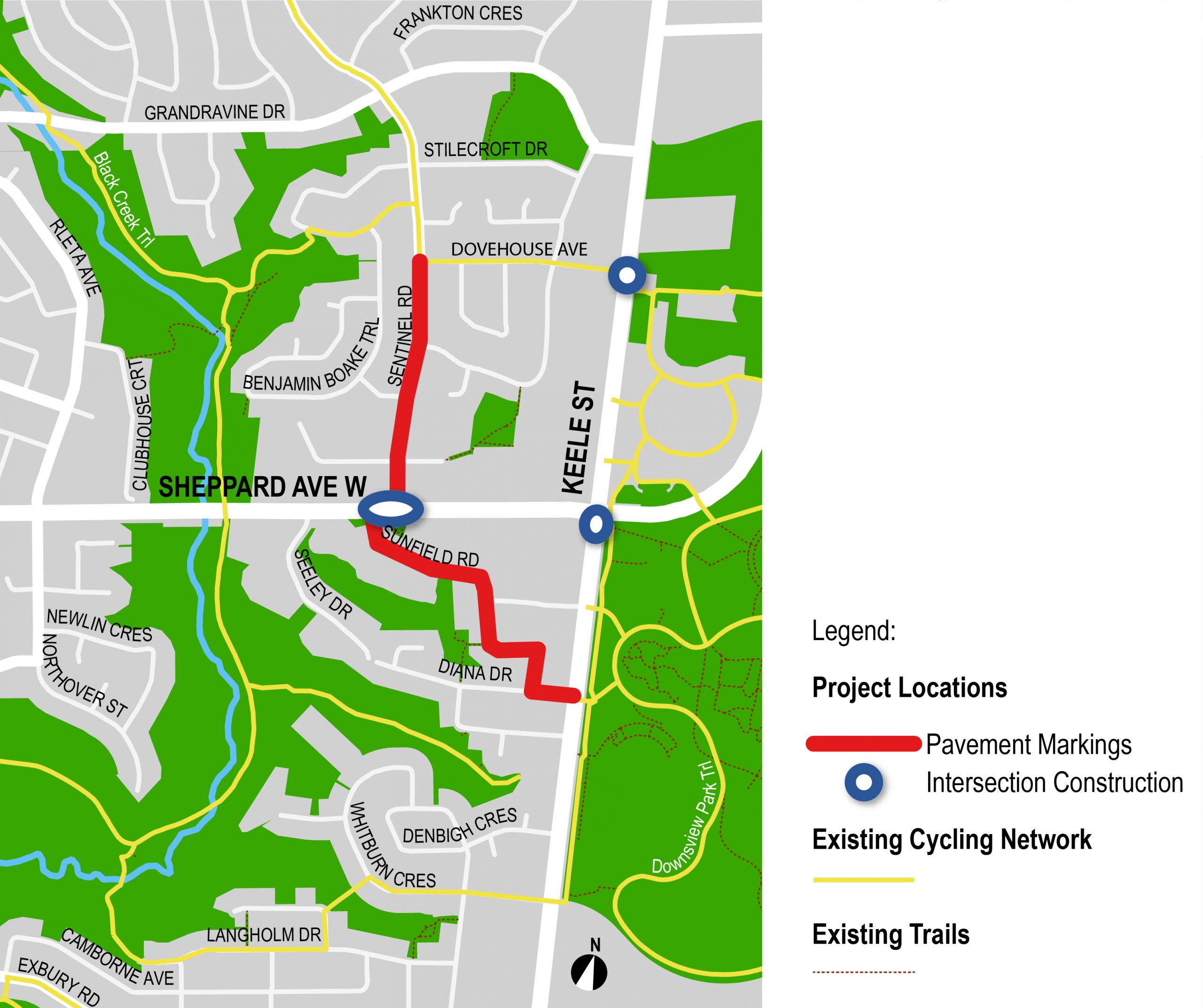
The study area for the Downsview Neighbourhood cycling facilities is bounded by Jane Street, Wilson Road, Keele Street, and Finch Avenue West.

What types of cycling facilities are being considered?

The City is proposing to install bike lanes, boulevard trails, and sharrows on various routes, as well as improved pathways to ravine trails (identified on the map).
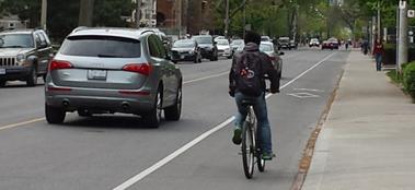
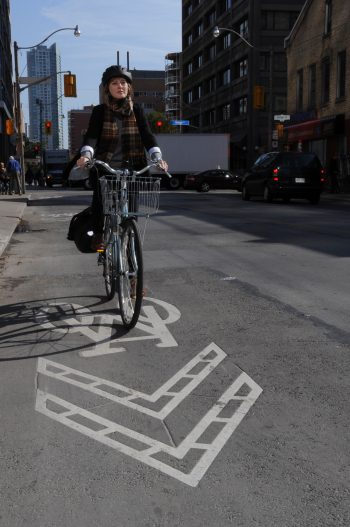
Bike lanes are a dedicated space for cyclists where motorists are not allowed to park, stop or drive. Bike lanes are painted on the road with bicycle symbols and a solid white line, and most importantly, a diamond symbol.  The diamond symbol is used on Ontario roads to indicate that a lane is a “reserved lane”.
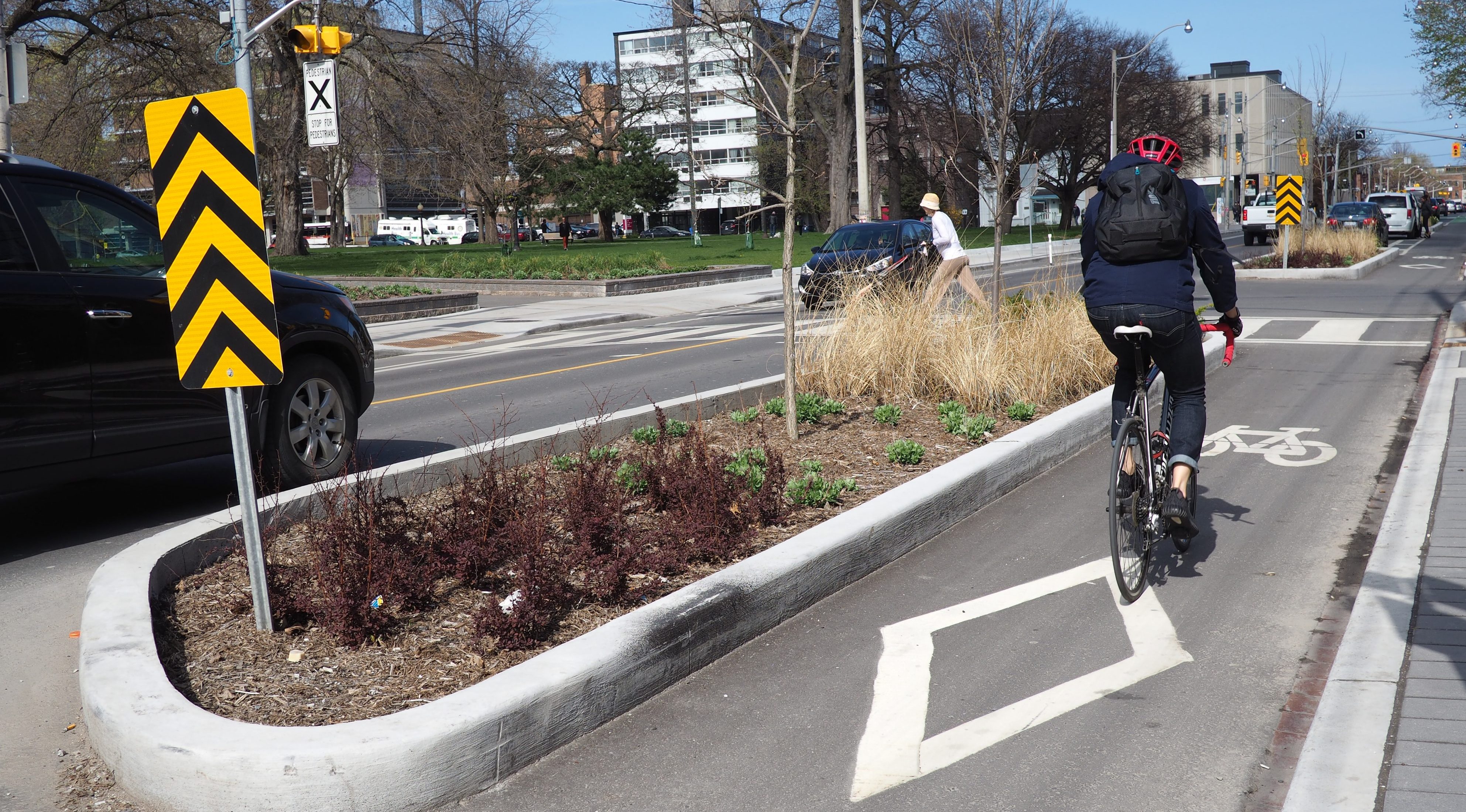
Example of a bike lane

Shared lanes or ‘sharrows’ are road markings used to indicate a shared environment for bicycles and motor vehicles. The shared lane markings highlight cycling routes alerting all road users to the presence of bicycle traffic on the street, and may also be configured to offer directional and wayfinding guidance for cyclists.  The shared lane marking is not a dedicated cycling facility, but a pavement marking which has a variety of uses to support a complete bikeway network.

Example of a sharrow

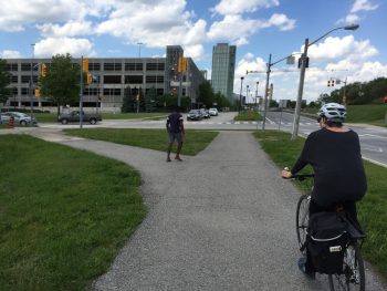
Boulevard trails are two-way paved surfaces that run along a roadway and are designed for pedestrians, cyclists and other non-motorized users. Trails are at or near sidewalk level, above and away from the curb and roadway. Ideally, separate sidewalks are also present, and if so buffers exist between them.

Example of a boulevard trail

What cycling connections are proposed to York University?

To enhance connections to York University, the City is proposing cycle tracks or bike lanes on Shoreham Drive (from Jane Street to the Pond Road) and Evelyn Wiggins Drive (along with a connection for cyclists to the adjacent trail that runs from Evelyn Wiggins Drive to the Pond Road). The City is also proposing a boulevard trail on Murray Ross Parkway (from Shoreham Drive to Steeles Avenue West), improved connections to the Black Creek Ravine, and extended sharrows on the Pond Road.

The City is working closely with York University to coordinate efforts and plan for cycling connections within and beyond the campus. Please visit the York University Transportation Services website for more information on cycling at YorkU.

What cycling routes are proposed in the Downsview Neighbourhood?

The City is proposing a number of cycling routes throughout the Downsview Neighbourhood and to connect to Downsview Park. These include:

  • Yorkwoods Gate (sharrow)
  • London Green Court (sharrow)
  • Sentinel Road (bike lane and sharrow)
  • Camborne Avenue (sharrow)
  • Sheppard Ave (boulevard trail between Sentinel and Sunfield)
  • Sunfield Road (sharrow)
  • Stilecroft Drive (sharrow)
  • Dovehouse Avenue (bike lane and shared lane)
  • Keele Street (boulevard trail from Dovehouse Avenue to Sheppard Avenue)

Will there be a physical separation on the proposed bike lanes, such as bollards, curbs or planters?

Yes, the City is considering physical barriers along the Shoreham Drive bike lane. Feedback from the public is welcome on this design.

How will funding be obtained?

Half of the project falls under City of Toronto capital funding, and half is contributed by the Federal Government. More information is available on the Federal Government’s website.

Will the proposed bike lanes affect on-street parking or traffic lanes?

Most bike lanes will not affect on-street parking. On some segments, parking studies have been conducted and public feedback will be sought to determine if parking demand can be met with the inclusion of dedicated bikeways.

Will there be private property impacts?

No. All new cycling facilities will be constructed within the City’s right-of-way.

Will the bike lanes be cleared of snow?

Yes. The bike lanes will include a maintenance program for snow clearing and street cleaning.

How do bike lanes affect waste pick-up and emergency services?

Proposed bike lane designs will accommodate waste pick-up, emergency services and other municipal services.

How do bike lanes affect TTC bus stops and Wheel-Trans?

City staff will develop the bike lane design in consultation with TTC staff. City staff will continue to work with the TTC to accommodate curb-side bus stops, and consideration for Wheel-Trans passenger boarding.

Where can I access information and resources on cycling in Toronto?

Visit toronto.ca/cycling to view information about cycling in Toronto including programs to start cycling and safety information.

If you have any questions about the project, please contact cycling@toronto.ca.


Under the Public Transit Infrastructure Fund (PTIF) – Phase 1, the Government of Canada is investing up to $309,500 for the York University and Downsview Cycling Connections Project. The City of Toronto is matching this funding contribution.