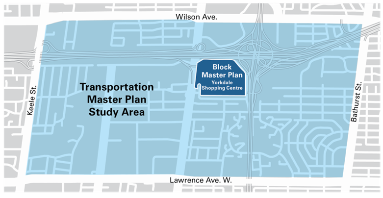
The City of Toronto carried out a Transportation Master Plan study to identify and address the long-term transportation improvements needed to support all road users within, and surrounding, the Yorkdale Shopping Centre site. The study area is bounded by Keele Street, Bathurst Street, Wilson Avenue and Lawrence Avenue West.
The City is also undertaking a Block Master Plan study for Yorkdale Shopping Centre as part of the review of a development application submitted by Oxford Properties, which includes a range of retail, office, hotel and residences proposed for the Yorkdale site over the next 20+ years.
With significant long-term development proposed for this area, the City must ensure that the required infrastructure is in place to support the existing and future needs of this area.
City Council has endorsed the Yorkdale Transportation Master Plan.
City Council has also requested Transportation Services to conduct further study on Preferred Solutions 23 and 34 and the feasibility of extending Dufferin Street north of Wilson Avenue to link into Allen Road going north.
You can watch the video of City Council meeting from the Toronto City Council and Committees web page or the City of Toronto’s YouTube channel ![]() .
.
On July 7, 2022, Infrastructure and Environment Committee (IEC) endorsed IE 31.10 – Yorkdale Transportation Master Plan.
A virtual public meeting was held on February 22, 2022.
A drop-in event was held on November 26, 2019.
A Transportation Master Plan (TMP) is a long-range plan that examines the transportation needs within an area and provides a framework and vision for the implementation of the recommended infrastructure improvements over a period of time.
The study is looking at opportunities to improve access, connections, and safety for all road users, including:
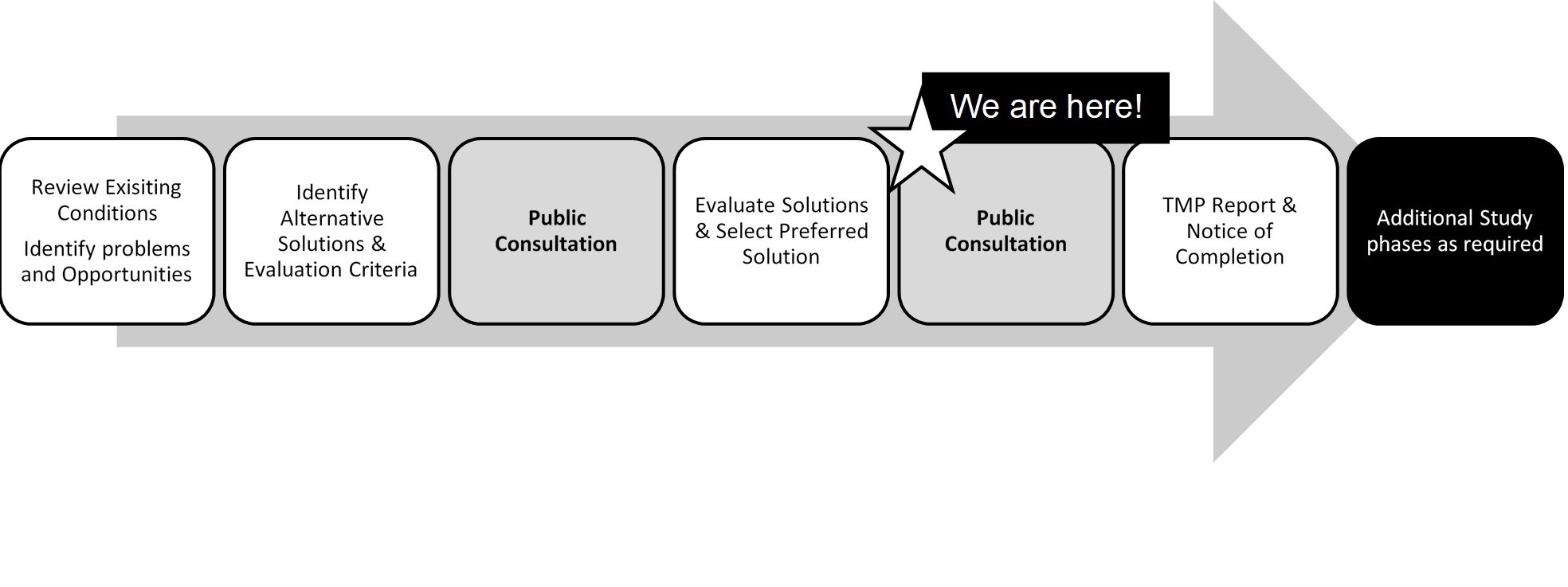
The study is following Phases 1 and 2 of the Municipal Class Environmental Assessment process. The process includes identifying the problems or opportunities, developing and evaluating a range of alternative solutions, and providing opportunities for public input.
Once complete, the study will recommend a set of transportation projects, initiatives and policies to support the anticipated growth and development of the area, improve mobility, flow and address the needs of the community.
In 2015, City Council adopted the Dufferin Street Secondary Plan creating a framework to guide future growth in the area between Highway 401 and just south of Lawrence Avenue West. The Plan promotes a mix of residential and commercial land uses, improved connectivity through new public streets and lanes, pedestrian and cycling infrastructure, and priority transit lanes.
Learn more about the Yorkdale Shopping Centre Block Master Plan.
The study did not recommend a vehicular connection at Cartwright Avenue or Bridgeland Avenue due to potential traffic infiltration impacts to the neighbourhood west of the rail line. The proposed bridge provides east-west connections for pedestrians and cyclists, and would be enclosed so snow removal or salting is not required.
Caledonia Road is an arterial road that is designed to move a high volume of motor vehicles. The proposed extension of Caledonia Road to Wilson Avenue would assist with alleviating traffic congestion on Dufferin Street. The Dufferin Street at Cartwright Avenue intersection can be designed to prevent through traffic between Yorkdale Shopping Centre and Caledonia Road which would minimize impact on Cartwright Avenue. The proposed extension would not adversely impact Wilson Avenue.
The Caledonia Road extension would impact nearby properties and require future phases as part of the Environmental Assessment process to look more closely at property impacts, construction methods, excavation requirements, and mitigation strategies regarding noise and dust. The City will have to purchase private property in order to facilitate the construction of the road. The City would meet with property owners prior to implementing any improvements requiring private property. The future development of the remaining property would be based on zoning, which could change. The property owner could apply to the City to change the zoning. The new road extension would be a minor arterial road, with two lanes of vehicle traffic (one going north, one going south), cycle tracks, sidewalks and trees.
The study examined the feasibility of a Caledonia eastbound off-ramp; however, there was insufficient space to ensure safe operations on Highway 401. Widening Highway 401 may also be required impacting several properties to the south.
The master plan considered a range of development scenarios totaling approximately 9,000 residents and 10,000 workers. By summer 2022, the City is expected to have policy direction to guide future developments through the Yorkdale Block Master Plan (BMP) study. No development-related construction is expected to start before 2024 and it would take a significant amount of time (20+ years) to realize the entire BMP vision. Based on the existing and proposed traffic infrastructure, the City may identify development caps.
The Downsview Airport lands were not taken into the account in this study because the Yorkdale Transportation Master Plan was initiated beforehand. The Downsview Airport lands will undergo a similar master planning process which will account for area developments like Yorkdale.
Dufferin Street is the central spine of the Dufferin Street Secondary Plan Area and will be an active and vibrant place that is designed around the landscaped Dufferin Promenade with pedestrian, bicycle and vehicular connections to the surrounding neighbourhood and employment areas. Development along Dufferin Street will define and support the landscaped promenade with high-quality design, landscaped setbacks and active ground floor uses to support the vision of a livable, walkable mixed-use community. A connected public realm of streets, blocks, parks, and open spaces will form the underlying structure for development of large parcels that will support the Dufferin Street Promenade.
The possibility of extending Dufferin Street will be reviewed as part of the Downsview Secondary Plan update.
The TMP focused on developing a robust street network that supports all road users with particular attention to improving transit, pedestrian and cycling facilities to reduce car dependence.
The request for traffic signals at Glen Belle Crescent & Dufferin Street, as well as the concern about illegal parking, have been forwarded to the Traffic Operations department for action.
Traffic flow and congestion were addressed through the transportation master plan process.
Illegal parking is an enforcement issue and can be reported through the City of Toronto Parking Enforcement office.
Although a pedestrian and cycling connection to Yorkdale Shopping Centre was once considered during the study, it is not being recommended and would remain a cul-de-sac.
The proposed transit/HOV lane would be in the curb lane (the furthest right lane in each direction). While drivers would be required to yield before merging into the proposed transit/HOV lane when they exit from the Highway 401 off-ramp travelling southbound, it would not be different than today as there is already a yield sign at this location.
As drivers travel on the transit/HOV lane from the off-ramp, they would be allowed to travel a certain distance in the same lane without having to immediately merge to the centre lane. Additionally, if drivers are travelling to Yorkdale Shopping Centre via the McAdam loop ramp, they could remain in the curb lane.
It would be easier to merge into the proposed transit/HOV lane because the lane would be dedicated to transit and high occupancy vehicles and typically have fewer vehicles.
One of the goals of the study is to promote walking, cycling, and transit use. Although the study examined vehicle connections, including connections over the Barrie GO rail corridor, the solutions were not recommended because they would result in more vehicles traveling through residential communities.
Within the Yorkdale site, the Master Plan’s vision is to promote cycling and pedestrian access. A reduced number of available parking spaces would also help control how many vehicles come to the mall. All these aspects would reduce traffic and support the new development growth.
The purpose of installing sidewalks on streets that currently do not have any is to provide safe routes for pedestrians as part of the City’s Vision Zero plan. Sidewalks are required to support accessibility, and keep people from walking in vehicle lanes, especially during winter.
New sidewalks are designed on a case-specific basis, and the expansion of sidewalks is dependent on requests from residents. Through this study, the City identified missing sidewalks; however, the community would be consulted further via their local Councillor’s office.
The Yorkdale Shopping Centre Block Master Plan study will examine the need for public parkland on site, including the size and location.
The study will also build upon the community services and facilities study done as part of the work for the Dufferin Street Secondary Plan. This may identify the need for additional spaces and/or improvements to existing facilities on the site or in the surrounding community.
The Yorkdale Local Advisory Committee is a non-political advisory body with the mandate to provide feedback to City staff on the Yorkdale Transportation Master Plan and Block Master Plan at key points throughout the two studies. Membership of the committee includes local residents and stakeholders.
The City is considering three delivery timelines: short-term (less than 5 years), medium-term (5 to 10 years) and long-term (10+ years). The delivery of these projects is dependent on additional design and/or Environmental Assessment approvals. The construction timeline for the delivery of the Cartwright pedestrian/cycle bridge would be dependent on available funding, including development funding, as well as pedestrian demand. The pedestrian/cycling bridge over Highway 401 would be determined as development proceeds. If new development pressures emerge on the north side of the highway, along with the Yorkdale development, then the need to accelerate infrastructure projects would be advanced.
Potential timelines for new infrastructure to be delivered are listed below:
| Pedestrian and Cycling Facilities Improvements | ||
| Short-term | Mid-term | Long-term |
| 24: Baycrest Park pedestrian / cycling switchback ramp/stairs
25A: Add sidewalks to local roads with no sidewalks 34: Sidewalks on Yorkdale Road |
26A: Pedestrian and cycling facilities along Bridgeland Avenue from Dufferin Street to Caledonia Road
21B: Pedestrian and cycling bridge (east- west) over Barrie GO Rail Corridor connecting Rustic Road to Cartwright Avenue 26B: Continuation of pedestrian and cycling facilities from 21B along Cartwright Avenue 34: Cycling facilities on Yorkdale Road 36: Large scale mobility hub – ride share and bike share (GO Bus Terminal) |
23: Pedestrian and cycling bridge (north-south) over Highway 401 connecting Yorkdale Road to Billy Bishop Way
28: East-west cycling facilities on Yorkdale Greenway* 35: North-south cycling connection on Street B between Yorkdale Road and Yorkdale High Street* 37: Small scale mobility hub – bike share (Yorkdale Green) 38A/B: Small scale mobility hub – bike share (Dufferin Park) *Dependent on the density of proposed development in the area; they could be implemented in the mid-term |
| Transit Improvements | ||
| Short-term | Mid-term | Long-term |
| 17: Dufferin Street Transit Priority (Transit/HOV Lane) – from Dufferin Street Secondary Plan | 18A: Two-way bus service on Yorkdale Road – Yorkdale High Street to Street B*
20A: Retention and expansion of the GO Bus Terminal *Dependent on the office development where GO Bus Terminal is located |
|
| Road Intersection Improvements | ||
| Short-term | Mid-term | Long-term |
| 10: Allow southbound left turn for all vehicles at the intersection of Dufferin Street/Bridgeland Avenue
11: Honda access and Yorkdale access to be normalized (aligned) with no offset |
12: Unsignalized separate truck access
13F: Maintain McAdam Loop with access to Yorkdale underground parking, and signalized intersection at Cartwright Avenue / Yorkdale Greenway 16: Contra-flow southbound left-turn on Yorkdale Road 32A: 401 EB off-ramp to Dufferin Street – Retain southbound curb lane for Transit / HOV |
14: New signalized full access to parking garage*
15: New unsignalized access on Yorkdale Road (Yorkdale Greenway connecting to Dufferin Street)* *Dependent on the phasing of the Yorkdale Shopping Centre development
|
| Road Infrastructure Improvements | ||
| Short-term | Mid-term | Long-term |
| 8: Modified on-ramp to northbound Allen Road, westbound and eastbound Highway 401 | 1A: Caledonia Road extension under Highway 401*
*Dependent on Dufferin Street capacity constraints as development applications are approved |
|
The study has been carried out following the Master Planning requirements under the Municipal Class Environmental Assessment (EA), which is an approved planning process under the Ontario Environmental Assessment Act. A Transportation Master Plan report is now available for a 30-day review period starting on January 19 and ending on February 17, 2023. See Notice of Study Completion for further details if you have any comments or questions.
For a copy of any of the appendixes, please contact us.
To receive project updates by email, please contact us and indicate that you would like to be added to the mailing list.