In July 2018, City Council directed staff to prepare an inter-divisional Midtown Infrastructure Implementation Strategy to address the phasing and coordination of improvements to community facilities, parks, the public realm, local transportation, sewers and watermains in the area over the next 5, 10 and 30 years. The Strategy builds on work completed in 2018 as part of the Yonge-Eglinton Secondary Plan, and identifies updated infrastructure needs based on the Provincially-approved Secondary Plan. The Strategy was developed through an inter-divisional working group led by City Planning, and was adopted by Council in June 2022.
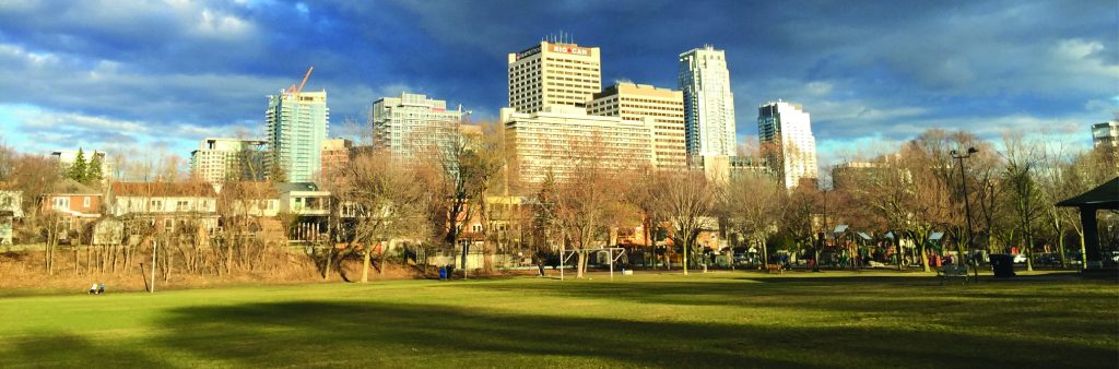
In recent years, Midtown has experienced the most development of any secondary plan area in the city outside of the Downtown, and the area is expected to continue experiencing significant growth over the next 30 years. The Midtown Infrastructure Implementation Strategy is based on the principle that growth in Midtown will be supported with investment in community facilities, parks, the public realm, local transportation facilities and municipal servicing over time, so that the area grows and evolves as a complete community.
The Infrastructure Implementation Strategy supports project delivery through annual updates to the 10-year capital plan and ongoing development review by creating a shared understanding of project needs in Midtown across all infrastructure types, as well as available funding tools, coordination opportunities, delivery mechanisms, and project phasing. The Strategy includes mapping of all planned projects across the near (2021-2026), mid (2027-2031) and long-term (2032-2051), as well as a framework for monitoring progress over time. Nine key actions are identified in the Strategy to focus efforts on infrastructure coordination, improving and expanding parkland and the public realm, and identifying sites with potential to accommodate new community facilities.
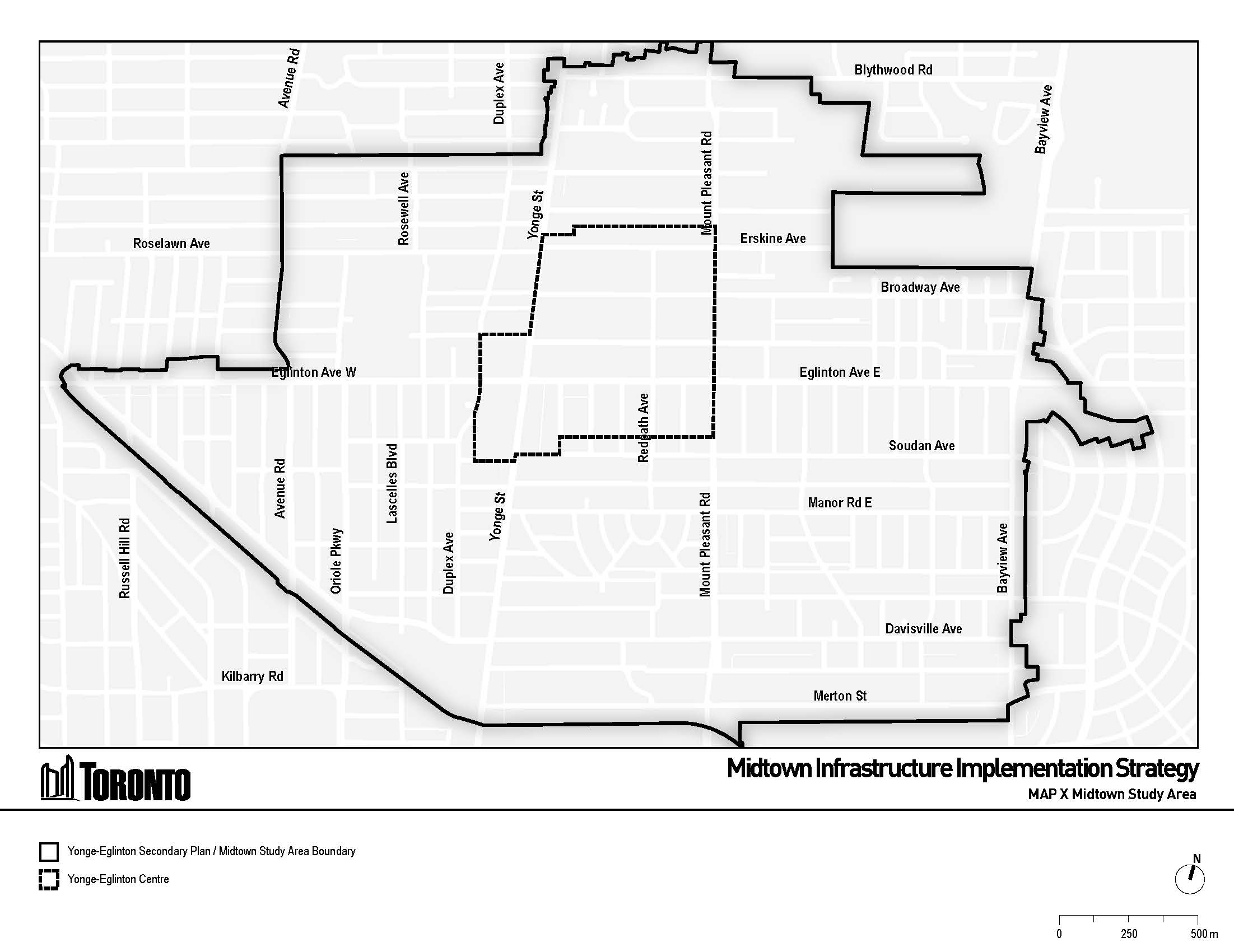
The Yonge-Eglinton Secondary Plan / Midtown Study Area is generally bounded as follows:
North: Briar Hill Avenue, Blythwood Road and Mount Hope Catholic Cemetery
East: Bayview Avenue
South: Mount Pleasant Cemetery
West: Chaplin Crescent
Building on the 2018 Midtown Community Services and Facilities Strategy, the Midtown Infrastructure Implementation Strategy (Section 5.2) provides an updated needs assessment based on the provincially-approved Secondary Plan and revised growth estimate, project-specific updates, and recommended phasing for future community facility projects that will be delivered by the City (Parks, Forestry & Recreation, Children’s Services), Toronto Public Library, School Boards and/or through development. Learn more about community facility projects in Midtown below.
Recently completed projects in Midtown include a new child care centre at Dunfield Avenue, the replacement of Davisville Junior Public School and repairs at the North Toronto Memorial Community Centre.
Near and mid-term projects that fall within the current 10-year capital planning cycle include the new Davisville Aquatic and Community Centre, additional child care centres, a new community space at 140 Merton Street, pupil space expansion at four elementary schools, and improvements to existing libraries (Mount Pleasant and Northern District).
A focus on securing new sites for community facilities will be required to deliver several of the long-term projects identified in the Strategy, such as additional schools and child care centres, and the relocation of existing community facilities (e.g. Mount Pleasant Library and Central Eglinton Community Centre). Supporting the identification of new sites for community facilities is identified as key action in Section 5.8 of the Strategy.
Planning will continue working with each sector to monitor implementation progress and actively pursue opportunities through development review and the capital planning processes.
It should be noted that school projects are determined through long-term accommodation planning by the School Boards, and are subject to provincial funding and approvals. The delivery of new child care facilities in Midtown will also be influenced by the Canada-Ontario early learning and child care agreement.
Park-related facility needs are outlined in Section 5.3 of the Midtown Infrastructure Implementation Strategy, and have been determined through a series of strategies, plans and studies, including:
Within the Strategy, new parks and improvements to existing parks have been mapped alongside other infrastructure and facility improvements to maximize the impact of improvements – particularly for park projects located adjacent to planned Public Realm Moves. The Strategy provides recommended prioritization and phasing for planned park projects over the near, mid and long-term. Several of the Strategy’s key actions (Section 5.8) are focused on expanding parkland. Learn more about park projects in Midtown below.
Recent improvements to the park system in Midtown include five completed parks (85 Keewatin Ave, Manor Community Green, Cudmore Creek Park, Montgomery Square Park, 66 Broadway Ave), and new secured parks along Broadway Ave, within the Montgomery-Helendale block, and other locations.
Park projects planned for the near and mid-term include new and expanded parks at Hillsdale Avenue Parkette, 20 Castlefield Avenue, Square at Roselawn, Soudan Priority Park Area, Canada Square Park, Montgomery/Helendale Parkette and improvements to Eglinton Park, Redpath Avenue Parkette and the Kay Gardner Beltline Trail as well as other targeted improvements and wayfinding throughout Midtown.
Other new parks, such as potential parks decking the Davisville Yard and the TTC Subway Trench, are identified for study and implementation over the long-term. Completing the stakeholder consultation for the ongoing Davisville Yard and McBrien Study is identified as a key action in Section 5.8 of the Strategy.
The majority of these park projects are expected to be delivered through City-led acquisitions and capital projects led by Parks, Forestry & Recreation, and through development. Additional delivery mechanisms, such as transfers, leases, partnerships and philanthropy, can also be used to deliver parks projects as opportunities arise over time.
Eleven Public Realm Moves were identified in the 2018 Parks & Public Realm Plan (PPR Plan) and included in the Yonge-Eglinton Secondary Plan. The recommended phasing and delivery mechanisms for Public Realm Moves is captured in Section 5.4 the Midtown Infrastructure Implementation Strategy. Additionally, a complementary Public Realm Implementation Strategy provides preliminary concept plans to guide the future design and delivery of nine of the eleven Public Realm Moves.
Section 5.5 of the Midtown Infrastructure Implementation Strategy addresses elements of the local transportation network that are identified as Priority Local Streets in the Yonge-Eglinton Secondary Plan. These are streets where it is a priority to improve connections to local community destinations such as schools, parks, and community spaces by enhancing sidewalks and cycling facilities.
Priority Local Street improvements are expected to be delivered primarily through the Transportation Services capital program. Streets are scheduled for renewal based on considerations such as the condition of existing infrastructure and facilities, existing and future service-levels, equitable distribution of investments, additional considerations regarding economic development, sustainability, and/or other factors, and coordination with scope and schedule of nearby projects.
Opportunities to implement Priority Local Street improvements and related improvements, such as new mid-block connections and laneways, will also be sought as part of the development review and approvals process.
Beyond the local transportation network addressed in the Strategy, the City is undertaking other initiatives to explore connectivity improvements between Midtown and Downtown. These are identified in Section 5.7 of the Strategy and include temporary cycling facilities on Yonge Street (installed in 2021 as part of ActiveTO and currently under review); a corridor study of Yonge Street and Duplex Avenue (identified in Cycling Network Near-Term Implementation Program); and the RapidTO Bus & Streetcar Priority Plan, which evaluated and ruled out surface transit priority routes on Yonge Street, Bayview Avenue, Mount Pleasant Road, and Avenue Road.
Section 5.6 of the Midtown Infrastructure Implementation Strategy includes Toronto Water’s assessment of future needs, recommended phasing and delivery mechanisms for improvements to watermains and sewers in the area. The future needs assessment is based on analysis conducted in 2018 and reviewed in 2021 to reflect the provincially-approved Yonge-Eglinton Secondary Plan and revised growth estimate, and additional analysis of sewer capacity and basement flooding risk in Midtown under Wet Weather Flow events.
The servicing improvements identified through the needs assessment are primarily focused on Level of Service improvements to combined and storm sewers in parts of Midtown to mitigate existing basement flooding risk. These improvements will be implemented by Toronto Water and the recommended phasing is provided in the Division’s 10-Year capital plan, which is reviewed annually, and reflected in the Strategy. Additionally, the Strategy identifies the role of Site Plan Control in ensuring development proponents implement site-specific mitigation for development-related discharges to the City’s storm and combined sewers, and construct buildings based on available watermain network capacity at the time of development in order to satisfy fire suppression requirements for their individual sites in accordance with all applicable regulations.