
Thank you for joining us at our open houses and town hall events between January 27 and February 12. You can review the open house display boards and reach us by email at mtsazoning@toronto.ca. Draft maps showing the 200 metre and 500 metre distances from each station area are available in the accordion section below.
Major Transit Station Areas (MTSAs) and Protected Major Transit Station Areas (PMTSAs) are defined areas within about 500 to 800 metres, or roughly a 10 minute walk, of subway stations, GO stations and streetcar stops. There are now 120 of these areas across the city, collectively known as P/MTSAs. Inside these areas, the Province requires that the City plan for growth and development through updated zoning.
The City mapped these areas and amended its Official Plan to formally establish them. These updates, called Official Plan Amendments (OPAs), needed to be approved by the provincial Minister of Municipal Affairs and Housing.
In August 2025, the Minister did approve Official Plan Amendments for 120 of Toronto’s P/MTSAs and increased the building heights and densities that would be allowed within them. The decision did not change the Council-adopted boundaries, or the minimum densities that are required only in PMTSAs. The Minister’s decision is final and cannot be appealed.
The City of Toronto is required to update its zoning by-laws to allow the new heights and densities. Staff are working on these zoning updates and will bring them to City Council in the second quarter of 2026.
This page provides updates about these zoning changes and the Minister’s decisions, as well as public engagement events and other opportunities to learn more about implementing zoning for station areas in Toronto. Further background information on P/MTSAs can be found on the City’s Official Plan Review page.
Review the Open House Information Boards from the Public Engagement Sessions.
City-wide Town Halls
Format: Virtual
Date and Time: January 21, 2026, 6:30 – 8:30 p.m.
Format: Virtual
Date and Time: February 11, 2026, 6:30 – 8:30 p.m.
Format: In-Person
Date and Time: February 12, 2026, 6:30 – 8:30 p.m.
Location: City Hall, Council Chambers
Address:100 Queen St W, Toronto, ON M5H 2N2
Toronto and East York Open House
Date and Time: January 27, 2026, 6 – 7:30 p.m.
Location: Bickford Centre / West End Alternative School
Address: 777 Bloor St W, Toronto, ON M6G 3H2
Etobicoke-York Open House
Date and Time: January 29, 2026, 6 – 7:30 p.m.
Location: Etobicoke Collegiate Institute
Address: 86 Montgomery Rd, Etobicoke, ON M9A 3N5
North York Open House
Date and time: February 3, 2026, 6 – 7:30 p.m.
Location: North York Memorial Community Hall
Address: 5110 Yonge St, North York, ON M2N 5W4
Scarborough Open House
Date and time: February 9, 2026, 6 – 7:30 p.m.
Location: Scarborough Civic Centre
Address: 150 Borough Dr, Scarborough, ON M1P 4N6
The Minister of Municipal Affairs and Housing’s decision increased the density and heights that Toronto’s City Council had approved for lands in the station areas. The City must now update its zoning by-laws to allow for the following building heights and densities:
Secondary Plans (Chapter 6 of the Official Plan) and Site and Area-Specific Policies (SASPs – Chapter 7 of the Official Plan) continue to apply to P/MTSAs. In the case of conflicts between Secondary Plans/SASPs and MTSAs and PMTSAs, whichever policies provide greater densities will prevail.
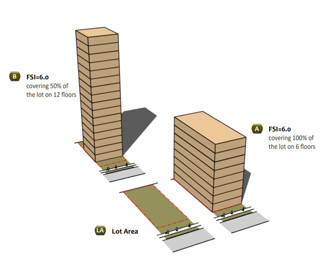
Floor space index (FSI) is a way of measuring density on a site. FSI is the floor area of the building, divided by the area of the lot.
Within P/MTSAs, on sites designated as Mixed Use Areas, Apartment Neighbourhoods or Regeneration Areas in Toronto’s Official Plan, the City’s zoning must allow an FSI of 8.0 within 200m of a transit station and an FSI of 6.0 on sites between 200m and 500m of the station.
For example, if a site is 1000 square metres and has an FSI permission of 6.0, one could build a building with 6000 square metres of floor area. This can be achieved using different built form and massing approaches. The image below shows different examples of achieving an FSI of 6.0.
A detailed P/MTSA dataset can also be accessed on the City’s Open Data website. The boundaries are provided in a standard ESRI Shapefile format and you need specialized GIS software to access these files. For more information, please see Open Data Learning Resources.
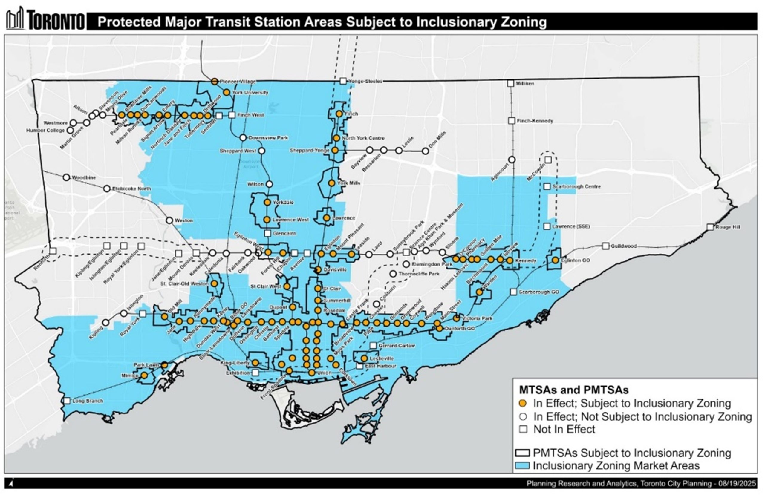
Inclusionary Zoning is a policy tool under the Planning Act that municipalities can use to require affordable housing in new residential developments located near public transit but only within PMTSAs, and subject to certain limitations. In Toronto, it is now in effect for 89 PMTSAs. In these areas, developers have to provide up to 5 per cent of the units they build (or 5 per cent of the floor area they build) as affordable housing, and these units must stay affordable for 25 years. Affordability is based on local incomes, not market rents.
Inclusionary zoning has been in effect in Toronto since August 15, 2025, with the requirement for developments to provide five per cent affordable housing for 25 years. On January 29, 2026, the Province filed Ontario Regulation 15/26 regarding Inclusionary Zoning, made under the Planning Act. While the new Regulation pauses Inclusionary Zoning implementation in Toronto until July 1, 2027, the City is still required by law to update its zoning for station areas by the spring of 2026.
This map shows station areas in Toronto and the Inclusionary Zoning market areas. Affordable housing requirements apply to developments located in both an Inclusionary Zoning Market Area and an approved PMTSA.
For more in-depth information on Inclusionary Zoning, please see:
Under the Planning Act, the City is not allowed to require that developments in P/MTSAs provide parking, including visitor parking. Parking can be provided voluntarily but it cannot be required by the Official Plan or zoning. As of August 15, 2025, any policy in an Official Plan or any regulation in a zoning by-law which applies minimum parking requirements to lands within a P/MTSA is no longer in effect.
Accessible parking is still required and must comply with the Accessibility for Ontarians with Disabilities Act, 2005 (AODA). The accessible parking rates and performance standards in the City’s Zoning By-law generally align with AODA requirements and were recently updated.
Staff are continuing to advance a small number of remaining MTSAs and PMTSAs, and most recently brought forward draft delineations for consultation in Q2 2024 (2024.PH17.14). These draft MTSAs and PMTSAs are not part of the current zoning implementation work.
The Minister withheld issuing a decision on 14 Council-adopted P/MTSAs. Station area policies will not be in effect in these areas until the Minister issues a decision.
Our team is working on providing fully accessible documents for the Major Transit Station Area Maps. If you require assistance understanding our maps or any other content, please contact the Station Area Zoning Project team at 416-338-5600 or mtsazoning@toronto.ca.
Official Plan Land Use Designations in Approved Station Areas
This map shows all the approved station areas in Toronto as well as their Official Plan land use designations.
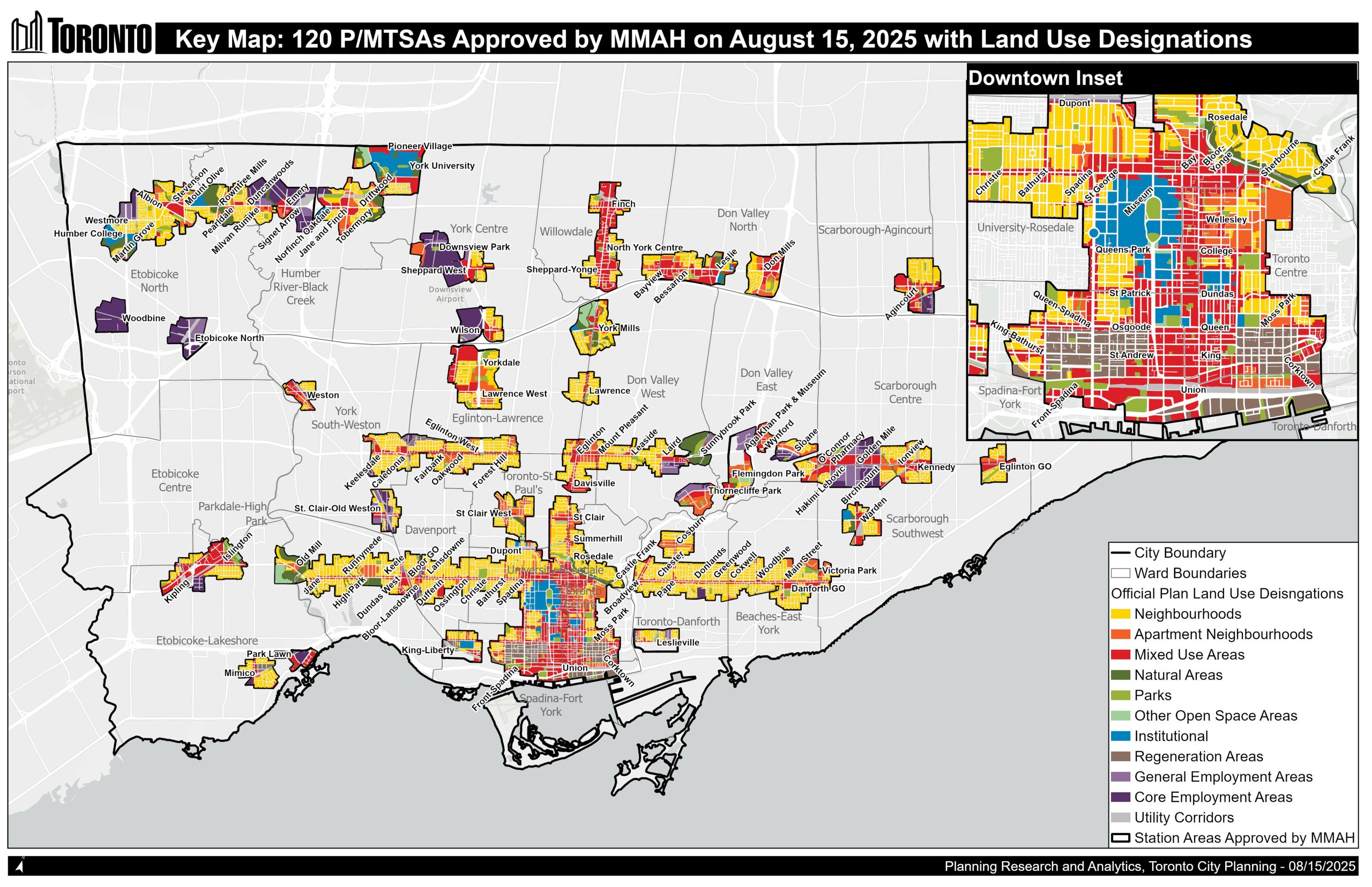
More detailed maps of all the approved station areas can be found in Chapter 8 of Toronto’s Official Plan.