
The Taylor Massey Creek is a tributary of the Don River, situated within a heavily urbanized section of Toronto, immediately east of the confluence of the West and East Don Rivers.
A planning process for Taylor Massey Creek was approved by Parks and Environment Committee on June 2, 2015, and City Council on July 7, 2015. Based on preliminary discussions with stakeholders, the process has been divided into three phases:
While we aim to provide fully accessible content, there is no text alternative available for some of the content on this site. If you require alternate formats or need assistance understanding our maps, drawings, or any other content, please contact Cheryl Post at 416-392-1948 or greentoronto@toronto.ca.
The Taylor Massey community was invited to review the Opportunities and Constraints and help develop Guiding Principles for the Master Plan Update at a public meeting held on Wednesday, June 21, 2017. Access the Community Meeting Summary Report and Presentation Panels that were used at the meeting:
The final report is posted online.
A second map-based survey was conducted to present the recommendations and proposed projects, to gauge public support and gather feedback. Summary report of findings to be posted in March.
Proposed solutions include the following:
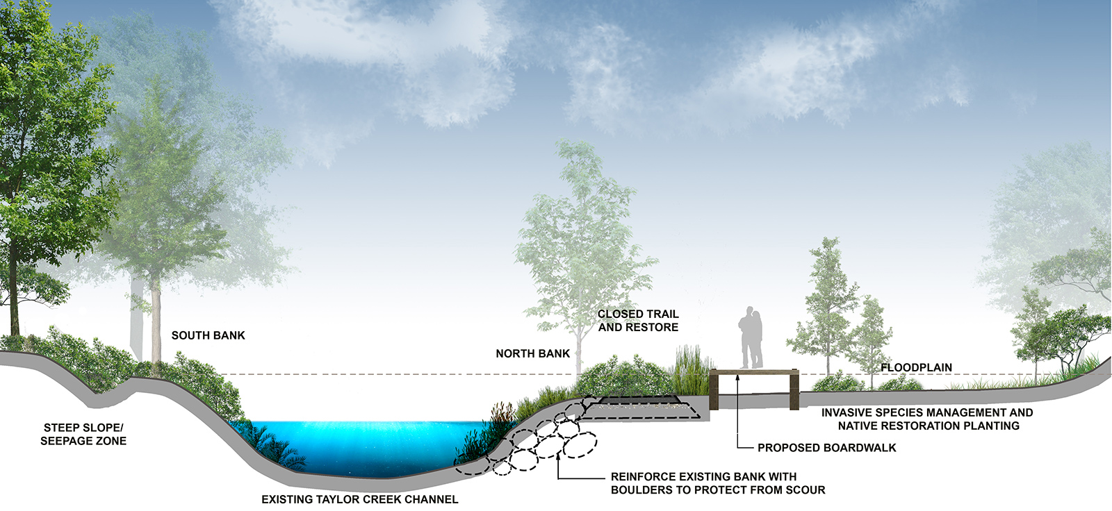
The existing washroom (just east of O’Connor) is to be removed and there is an opportunity to remove invasive species and create a new wetland for improved flood storage and enhanced habitat potential.
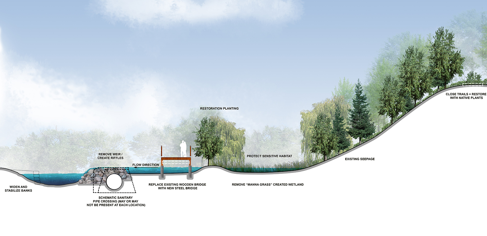
Within the creek weirs that function as in-water vehicle crossing structures act as barriers to fish migration and should be considered for removal wherever feasible. The adjacent bridges should also be replaced with wider steel structures to accommodate maintenance vehicles.
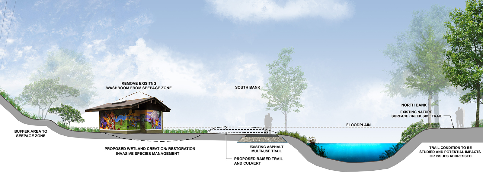
The existing washroom (just east of O’Connor) is to be removed and there is an opportunity to remove invasive species and create a new wetland for improved flood storage and enhanced habitat potential.
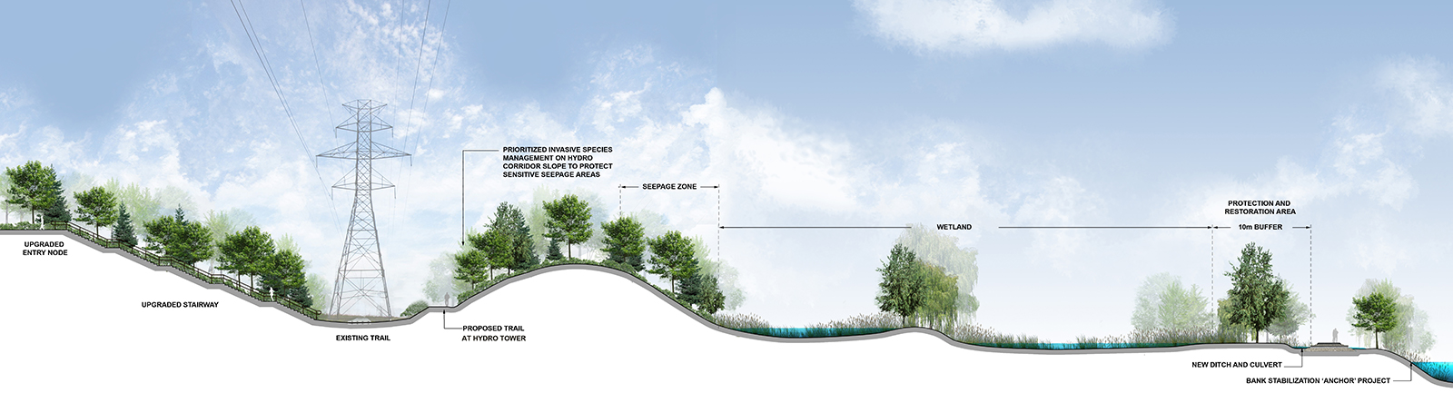
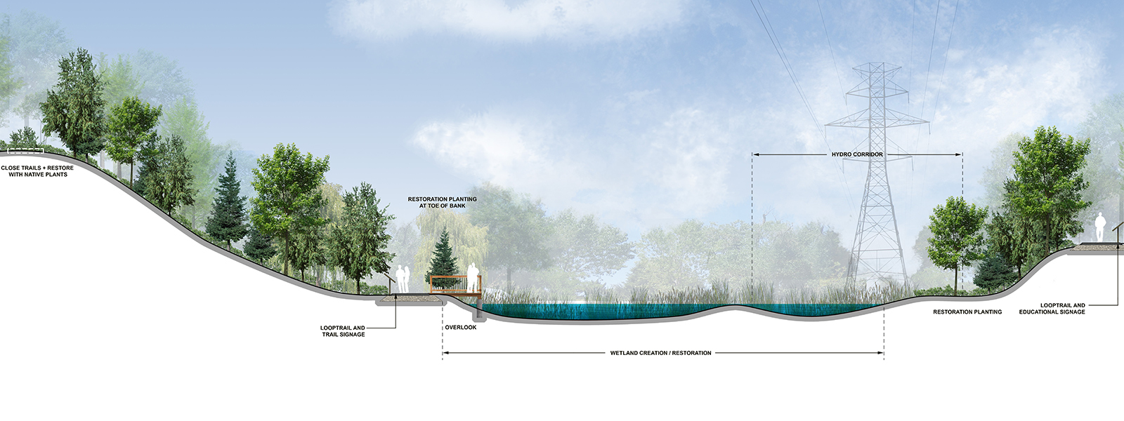
A new gravel trail is proposed along the Hydro corridor, to help reduce impacts on the adjacent sensitive wetland areas. Educational signage and a 10 m buffer zone will help protect this high-quality habitat.
Within the Goulding Estate, there is a drainage problem causing ponding water across the trail. Solutions could include new culverts or elevating as a boardwalk, to enable the creek to flow beneath, but will need to consider impacts to pedestrian, cycling and vehicle access.
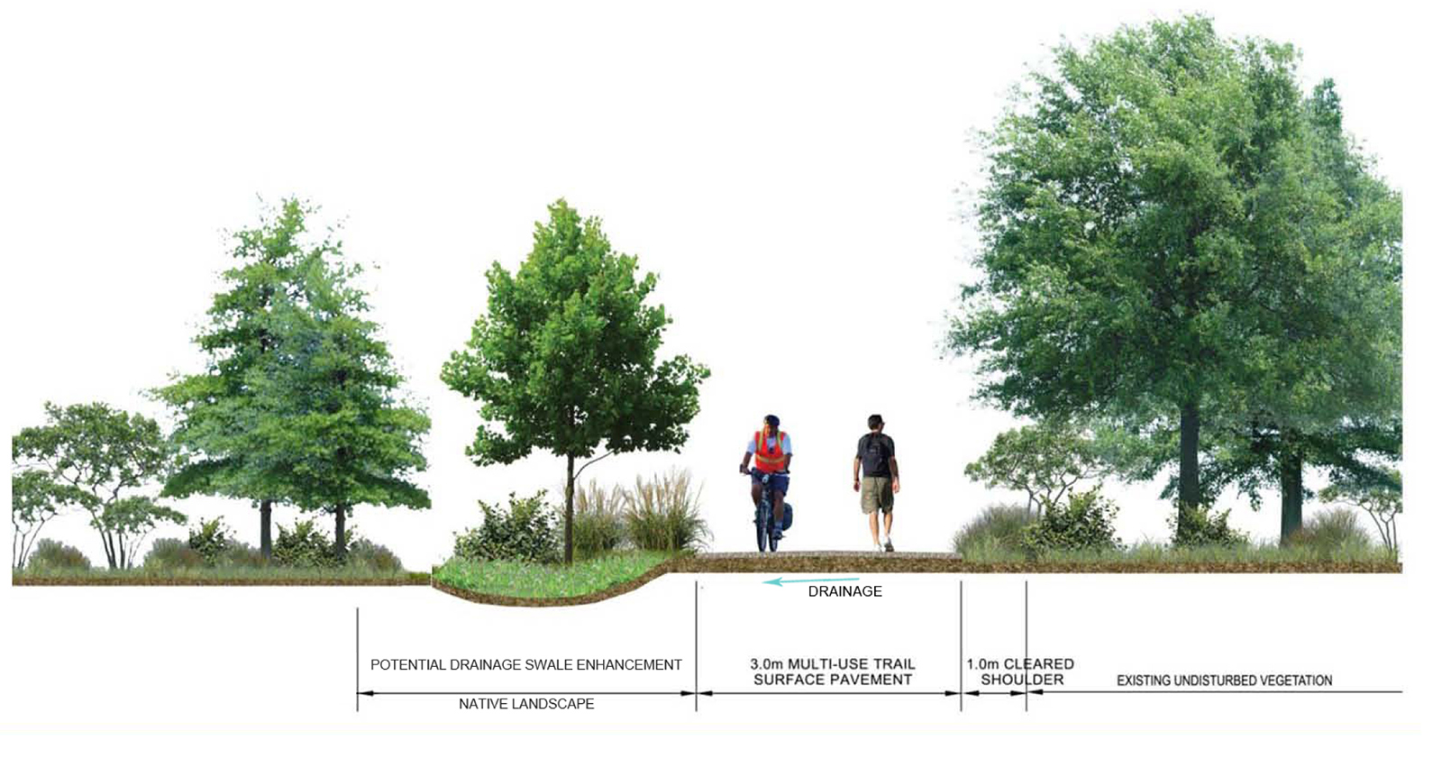
In some locations, the multi-use trail needs improvements to fix drainage problems and degraded asphalt. Ongoing maintenance will be required to keep adjacent ditches and culverts clear.
This meeting provided an update on the Taylor Massey Creek planning process and allowed the community to provide feedback on the proposed themes, strategies and potential projects. Download materials from the meeting:
A map-based online survey was conducted to gather information on public use, opportunities and constraints.The summary can be read online.
On July 27, 2018 in the afternoon and July 28, 2018 in the morning, Pop-up in the Park events were held at Taylor Creek Park, just north of Stan Wadlow Park.
The Management Plan process was launched at the “What’s Happening in our Ravines” community meeting at Stan Wadlow Clubhouse.
The Taylor Massey Master Plan is a sub-watershed scale plan for the improvement, management, maintenance and public use of the parkland along Taylor Massey Creek. The Master Plan considers the study area’s diversity of features and functions and their interconnectedness, including natural areas, park infrastructure, recreational amenities, trails, stormwater facilities and other utilities.
While we aim to provide fully accessible content, there is no text alternative available for some of the content on this site. If you require alternate formats or need assistance understanding our maps, drawings, or any other content, please contact Cheryl Post at 416-392-1948 or greentoronto@toronto.ca.
Download the final Taylor Massey Sub-Watershed Master Plan report.
Building upon the recommendations of the Master Plan, the Taylor Creek Park Management Plan was undertaken to identify and coordinate park-scale initiatives for the preservation, enhancement, management and maintenance of Taylor Creek Park.
Now complete, the Management Plan proposes and prioritizes opportunities for improvements across Taylor Creek Park, including ecosystem management, watercourse function, infrastructure and trails, recognizing the balance between recreational uses and the natural environment heritage of the park. The plan identifies numerous Coordinated Improvement Areas centred on larger Anchor Projects, a number of Quick Win stand-alone projects, as well as Park-wide recommendations.
Developed with the principles of the Ravine Strategy as its foundation, the Plan aims to help facilitate staff coordination, engagement and efficiencies across project types. The Management Plan process was led by the City, with support and input from the Toronto and Region Conservation Authority (TRCA). The process also included extensive public consultation.
While we aim to provide fully accessible content, there is no text alternative available for some of the content on this site. If you require alternate formats or need assistance understanding our maps, drawings, or any other content, please contact Cheryl Post at 416-392-1948 or greentoronto@toronto.ca.
Download the Taylor Creek Park Management Plan final report.