The City of Toronto undertook a Transportation Master Plan (TMP) to study five bridges within the Rouge National Urban Park (RNUP). Many of these historically and architecturally significant bridges were built in the 1900s and now require repairs. The bridges provide crossings over the Rouge River and Little Rouge River. Additionally, there are two CP Rail corridor underpasses in the RNUP that were considered as part of the TMP. The TMP recommended a set of priorities, design options and strategies to support any necessary repairs, replacement, or closures.
City Council (IE11.5) has adopted staff recommendations for the Rouge Park Bridges Transportation Master Plan Environmental Assessment Staff Report with amendments.
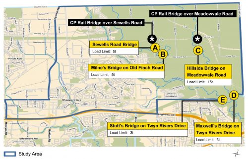
| Bridge | Date | Description |
|---|---|---|
| A - Sewells Road Bridge1 | 1912 | One of the oldest bridges in former Scarborough, it is believed to be the only remaining suspension bridge on a public road in Ontario. |
| B - Milne's Bridge on Old Finch Road2 | 1988 | A two-span Bailey Bridge, which replaced the previous structure from 1954. |
| C - Hillside Bridge on Meadowvale Road1 | 1917 | The bridge is a Pony Warren Truss. It carries local traffic across the Rouge River to the Hillside community. |
| D - Maxwell's Bridge on Twyn Rivers Drive1 | 1927 | Built over Little Rouge River for access to saw and grist mills and a woolen factory, 19th century industries that reflect the historic rural environment. |
| E - Stott's Bridge on Twyn Rivers Drive1 | 1915 | A one-lane wide, steel pony truss bridge. This bridge was temporarily closed for repairs in the summer of 2020. |
1 Designated as heritage for historical and structural reasons.2 Listed for possible heritage designation.
Each bridge has a load limit in place, which limits their use by heavy vehicles, such as trucks and emergency vehicles.
As part of the agreement with Parks Canada, the agency responsible for the Rouge National Urban Park, the City of Toronto owns and manages transportation infrastructure within its boundaries and provides basic municipal services, such as Police, Fire and Emergency Services and winter maintenance among others.
A Transportation Master Plan, or TMP, is a long-range plan that examines the transportation needs within an area and provides a framework and vision for the implementation of the recommended infrastructure improvements over a period of time. The study was carried out as a Municipal Class Environmental Assessment (MCEA) Study (Schedule B). The MCEA process, an approved planning process under the Ontario Environmental Assessment Act, includes providing opportunities for public input at key stages.
The study looked at opportunities to improve access, conditions, and safety for all road users. Key features of the study included:
Public Consultation took place from December 2020 to July 2022 in two phases to introduce the project to the community and identify overall needs and priorities. The consultation reports linked below provide a detailed summary of all activities that took place and feedback received through each.
The study was carried out following the requirements for Schedule B projects under the Municipal Class Environmental Assessment process.
A Master Plan Report was available for a 30-day review period from March 7 to April 6, 2025. See the Notice of Study Completion for details.