

Higher speeds contribute to an increased risk of serious injuries and fatalities. They reduce driver reaction time, increase the vehicle stopping distance and inflict more severe blunt force trauma on victims upon impact.
The City of Toronto is currently reducing speed limits to curb speeding on our roads. This is part of a holistic Speed Management Strategy as outlined in the City’s Vision Zero Road Safety Plan.
Residents in Toronto can also use the tools and resources outlined in the Safe Speeds Toolkit to address speeding concerns in their neighbourhoods.
Submit a service request to:
The City’s Speed Management Strategy aims to reduce the number of traffic-related injuries and fatalities associated with speeding through short and long-term measures, which include revised speed limit setting practices, road design improvements, enhanced police enforcement, proactive deployment of Watch Your Speed signs and public education and engagement campaigns.
Speed limit reduction is considered a shorter term initiative that can be implemented quickly but is not as effective as some of the longer term initiatives such as modifying the design of the roadway, which take several years to plan, program, design and implement.
More details about the City of Toronto’s Speed Management Strategy are in the June 2016 Vision Zero 2.0 – Road Safety Update staff report to City Council.
Considerations of speed limit reductions were made for all arterial roads with current speed limits over 50 km/h and all collector roads with current speed limits over 40 km/h. Each segment was evaluated and exceptions to speed limit reductions were made based on the following criteria:
The criteria is intended to exclude road segments where lower speed limits would be artificially low for the existing road environment and that create significant speed differentials, which would be a safety concern. However, exceptions were not made in the following situations:
Road designations, including arterials and collectors, are determined as part of Toronto’s Road Classification System. City staff maintain a map highlighting the designation of each road in Toronto.
As part of Toronto’s Vision Zero 2.0 - Road Safety Plan City Council approved reducing the speed limit on all local roads to 30 km/h.
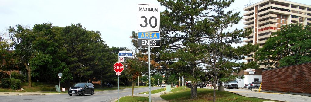
The City began installing the new 30 km/h area speed limit signs in 2021. The work is being completed ward by ward, with priority given to areas with higher rates of pedestrian and cyclist collisions. All wards are planned to be completed by 2028.
The new speed limits are being implemented using an area-based approach. Rather than installing a speed limit sign on every local street within a designed area, signs are placed at key points where people driving enter or leave a 30 km/h area. For example, signs will be located at all entry and exit points when a local street connects with a road that has a higher speed limit.
As a result, residents may notice fewer speed limit signs on individual local streets. This does not mean signs are missing. The goal is to create a consistent system across Toronto where people driving see 30 km/h area signs when entering a neighbourhood and understand that the speed limit continues to apply throughout the local road network, and that the speed limit is always 30 km/h on local roads.
A public education campaign on the rollout of local road reductions has been created to address concerns and raise awareness about this City-wide initiative.
The City classifies streets according to the Road Classification System, which identifies roads as local, collector, minor arterial, major arterial and other classifications. Residents can use the City’s Road Classification map to check how a particular street is classified.
Road designations, including local roads, are determined as part of Toronto’s Road Classification System. City staff maintain a map highlighting the designation of each road in Toronto.
Ward 5 and 7: Agenda Item 2021.EY24.21
Ward 1 and 3: Agenda Item 2022.EY32.13
Eatonville – Ward 2: Agenda Item 2025.EY27.6
Ward 6 and 18: Agenda Item 2021.NY24.20
Ward 8 and 16: Agenda Item 2022.NY32.22
Ward 15: Agenda Item 2026.NY32.14
Ward 17: Agenda Item 2025.NY22.24
Ward 21 and 23: Agenda Item 2021.SC24.15
Ward 20 and 24: Agenda Item 2022.SC32.11
Ward 4, 9, and 19: Agenda Item 2021.TE25.20
Ward 12: Agenda Item 2023.TE7.65
The table below summarizes the approach to lowering the posted speed limits in arterial, collector and local roads. The Toronto Road Classification System provides and overview on the mechanisms involved in classifying each road in the City.
| Road Classification | Proposed Change | Process | Implementation |
|---|---|---|---|
| Major Arterial | 60 km/h to 50km/h | Vision Zero 2.0 Report | 2020 to 2021 |
| Minor Arterial | 60 km/h to 50km/h | Reports to appropriate Community Councils in 2019 | 2020 to 2021 |
| Collector | 50 km/h to 40km/h | Reports to appropriate Community Councils in 2019 | 2020 to 2021 |
| Local | 50 km/h or 40km/h to 30km/h | Reports to appropriate Community Council | 2021 to 2028 |
The first phase of the Speed Management Strategy, from November to December 2019, saw the speed limit on approximately 250 kilometres of major arterial roadways reduced from 60 km/h to 50 km/h. The second phase was completed in 2020 and saw the speed limit on approximately 250 kilometres of minor arterial and collector roadways reduced from 50 km/h to 40 km/h.
The third phase of the Speed Management Strategy, beginning in 2021 with planned completion in 2028, is currently reducing the speed limit on local roads and public lanes in Etobicoke, North York and Scarborough to 30 km/h to bring the rest of the city in line with a consistent 30 km/h speed limit on all local roads. (Speed limits on local roads and public lanes in the Toronto East York Community Council area were approved in 2015 and 2016 and have been since implemented.)
You can use the Vision Zero Mapping Tool to view where the speed limits have been changed in Toronto.
There’s little evidence that the proposed speed limit reductions will impact travel times.
Studies have shown travel time is more dependent on congestion, roadway design and geometry factors than on the posted speed limits. Under medium congestion levels (where traffic is periodically able to travel at or near the speed limit), a lower speed limit may actually reduce overall travel time by allowing a smoother traffic rhythm because lower speeds reduce safe space required between vehicles.
Additionally, unlike in freeway conditions, the average speed for a typical trip is well below the posted speed limits of arterial roadways in the urban road environment
The average speed is more dependent on the nature of stop-and-go traffic as a result of congestion, roadway design and geometry factors than on posted speed limits
The City works with the Toronto Police Service (TPS) to identify locations where targeted traffic enforcement can help improve road safety. Collision data is used to identify areas where speeding as contributed to injuries or where there is a higher risk of collisions.
Police enforcement is focused on these higher-risk locations, which are typically on major arterial, minor arterial and collector roads. Targeted enforcement is paired with automated measures including red light cameras at higher risk intersections.
Slowing down saves lives. Explore the City's public education campaign informing residents about this important change to local speed limits.