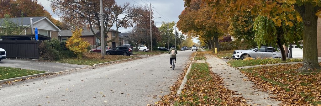
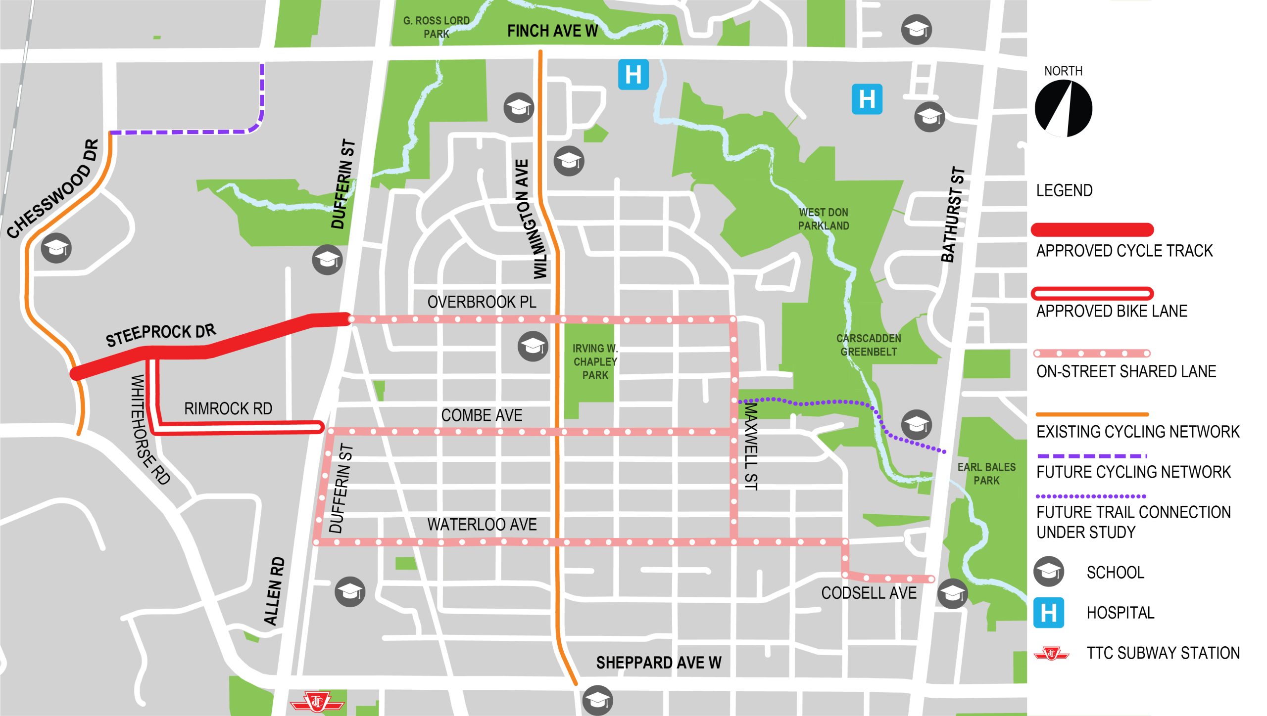
The City has installed cycle tracks on Steeprock Drive, bicycle lanes on Whitehorse Road and Rimrock Road, and on-street shared lane markings on several streets in the Bathurst Manor area. These changes are part of a plan to improve road safety and build connected cycling routes from Bathurst Street to the Finch Hydro Corridor. City Council approved the project in June 2024 (IE.14.4) and the project was installed between August and September 2024.
October 2024: The Steeprock-Bathurst Manor Cycling Connections project has been installed. The City will continue to monitor travel patterns in the project area and make adjustments, where necessary.
August 2024: Starting August 11, 2024 weather permitting, the City will begin installing cycle tracks on Steeprock Drive and painted bicycle lanes on Whitehorse Road and Rimrock Road. View the installation notice.
On-street shared lane marking installation began in Bathurst Manor in June 2024 and will be completed in August and September as part of this work. Based on feedback, the sharrow route has been slightly adjusted. The following routes were installed in June 2024:
July 2024: City Council has approved the installation of cycle tracks on Steeprock Drive and painted bike lanes on Whitehorse Road and Rimrock Road. A copy of the staff report is available at IE.14.4. Information about installation will be shared in the coming weeks.
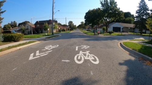
June 2024: Starting on June 10, the City will begin installing shared lane markings within the City’s right-of-way on select streets in Bathurst Manor. The pavement markings will include painted bicycle icons and directional arrows to help guide people cycling through the neighbourhood to the nearest recommended cycling routes.
On-street shared lane markings will be installed on:
City services such as Fire, Paramedics and garbage pick-up will continue as usual.
View the Installation Notice for more details.
May 2024: Staff recommendations for Steeprock-Bathurst Manor Cycling Connections were adopted by Infrastructure & Environment Committee on May 28. City Council will consider the recommendations on June 26-28. A copy of the staff report is available at IE.14.4. A Consultation Summary is now available.
*Please note: Based on feedback, the sharrow route was slightly adjusted on Codsell Avenue, Maxwell Street, Waterloo Avenue, and Hove Street.
The Steeprock-Bathurst Manor Cycling Connections project included changes to:
On Steeprock Drive, the following was installed:
Bikeways on these streets have been installed to improve connections between the Bathurst Manor neighbourhood and businesses, employment, and parks west of Allen Road via an existing path at Combe Avenue and Allen Road.
On Whitehorse Road and Rimrock Road, the following was installed:
The Bathurst Manor Neighbourhood is a residential area with local and collector streets and destinations such as schools and parks. Most streets in the neighbourhood are approximately eight metres, which is not wide enough for two-way travel and dedicated bike lanes.
On-street shared lane markings and signage were installed in the Bathurst Manor neighbourhood where people cycling and driving share the roadway. These markings improve road user awareness and help people cycling with navigation. There are no impacts to motor vehicle lanes or parking.
On-street shared lane markings were installed on:
Combe Avenue, Dufferin Street and Waterloo Avenue were included for on-street shared lane markings to provide options for routing within the Bathurst Manor Neighbourhood along streets with lower motor vehicle volumes. These streets also improve connections to proposed bike lanes on Rimrock Road via the pathway to Allen Road at Combe Avenue.
The Bathurst Manor Neighbourhood Mobility Plan (BMNMP) identified, prioritized, and recommended short-, medium-, and long-term improvements to traffic operations and road design to support safety for all modes of transportation, including pedestrians and people driving and cycling. More information about this plan can be found on the BMNMP website.
Public Consultation took place from January to April 2024 and included a mailed postcard about upcoming cycling projects in the Bathurst and Finch area, a public notice to the project area, a pop-up event, in-boulevard signs in the community, and email/phone comment tracking, and a meeting with the DUKE Heights Business Improvement Area. A summary of what we heard can be found in the consultation report:
The installation of the cycle tracks on Steeprock Drive involves pavement marking removal and installation, and installation of pre-fabricated concrete barriers and bollards. There is no full roadway reconstruction as part of the project. If approved, installation is expected to take up to a few weeks with limited impacts to traffic. Typically, pavement marking installation occurs overnight and concrete barriers installation during the day. In total, the installation is expected to last a few days. Steeprock Drive and the intersections along it will remain open to traffic during installation. After installation, there will continue to be one lane of traffic in each direction on Steeprock Drive.
For the bike lanes on Whitehorse Road and Rimrock Road, and on-street shared lane markings in Bathurst Manor, installation involves pavement marking installation and sign installation and is expected to take up to a few days. Typically, pavement marking installation occurs overnight. Whitehorse Road and Rimrock Road would remain open to traffic during installation.
The Steeprock-Bathurst Manor Cycling Connections project aims to improve safety for pedestrians, and people cycling and driving, and enhance the walking and cycling experience. As part of the project, the project team reviewed traffic data and consulted with representatives of emergency services, businesses and the Business Improvement Area (BIA).
On Steeprock Drive, one motor vehicle will remain in each direction. The centre turn lane along Steeprock Drive will be removed as well as the westbound left-turn lane at Chesswood Drive opposite of the driveway. The eastbound left-turn lane at Steeprock Drive and Dufferin Street will remain. The removal of the centre turn lane and westbound left-turn lane at Chesswood Drive was informed by a review of vehicle volumes on the road and at the intersections, and it was determined that these changes can be accommodated with acceptable operations remaining along the route.
Vehicular travel lanes will remain the same on Whitehorse Road and Rimrock Road with one motor vehicle lane per direction. The eastbound left-turn lane at Rimrock Road and W.R. Allen Road will be removed. A review of existing traffic volumes on Whitehorse Road and Rimrock Road was done, and it was determined that these changes can be accommodated with acceptable operations.
There are no impacts to vehicular travel lanes in Bathurst Manor and no traffic impacts are anticipated.
City services such as fire, emergency medical services, solid waste pick-up, and snow clearing will continue as usual.
The 2022-2024 Cycling Network Implementation Plan identified a number of routes in the Bathurst and Finch area that, once completed, will form a connected route allowing people cycling to safely reach community destinations like the Finch Hydro Corridor, Earl Bales Trail and Downsview Park. These bikeways support the City’s TransformTO goals to reduce greenhouse gas emissions, and Vision Zero targets to eliminate all traffic-related deaths or serious injuries. Chesswood Drive was the first section completed, and additional routes are planned on Champagne Drive, Steeprock Drive and through Bathurst Manor to connect to Bathurst Street. We anticipate use will increase as the rest of the network is built out and awareness of the cycle tracks increases.
Existing TTC stops on Steeprock Drive and Whitehorse Road will not be removed or relocated. The cycle tracks and bike lanes will be designed to enable buses to stop at these locations as they did previously. There is also no planned re-routing of buses during installation. Buses will be able to maneuver around the site during the time it takes to do the installation.
The pavement markings and signs proposed in Bathurst Manor are on-street shared lane markings. They are not separate bike lanes or cycle tracks, and would not impact parking, motor vehicle lanes, or involve re-construction. An example of a route with on-street shared lane markings is Faywood Boulevard south of Reiner Road.
Examples of signage that would support the on-street shared lane markings includes ‘share the road’ signs, wayfinding signs, and other signs specific to intersections that warn drivers, where applicable, of pedestrians or people on bikes crossing. Signs would only be placed on City right-of-way.
Proposed designs for Steeprock Drive, Rimrock Road and Whitehorse Road take into account the width required for large trucks and TTC buses to travel safely, as well as the sizes of intersection and driveway corners needed for trucks turn and to enter and exit. Barriers on Steeprock Drive will have sufficient gaps to enable turning movements for trucks.
The Cycling Network Plan and the associated Near-Term Implementation Plan, adopted by City Council in December 2021, seeks to build on the existing network of cycling routes to connect gaps in the current network, grow the network into new parts of the city, and renew existing parts of the network to improve safety. The most recent Council approved Cycling Network Plan for 2022-2024 identifies Steeprock Drive, Overbrook Place, Maxwell Street and Codsell Avenue for cycling improvements to connect destinations and neighbouring cycling routes.
This project is also a part of the City’s TransformTO: Climate Action Strategy objectives, which has a target for 75% of trips under 5 km to be walked, cycled, or taken by transit by 2030 and the City’s commitment to the Vision Zero Road Safety Plan. The plan aims to eliminate traffic-related fatalities and serious injuries by making our roads safer for everyone. Within the last 10 years (2013-2022), there have been 331 reported collisions on Steeprock Drive, Whitehorse Road, and Rimrock Road with five collisions involving pedestrians and five collisions involving people cycling.
To receive project updates by email, please contact us and indicate that you would like to be added to the mailing list.
Personal information is collected under the authority of the City of Toronto Act, 2006. The information is used to allow the City to send you emails about project updates and future consultation opportunities. Questions about this collection may be directed to the Manager, Public Consultation at 416-392-2990 or tracy.manolakakis@toronto.ca