The City of Toronto has completed a Municipal Class Environmental Assessment (MCEA) study to identify solutions to protect sewer and watermain infrastructure within Newtonbrook Creek and Blue Ridge Creek that are at risk of damage as a result of erosion caused by high flows from storms and snow melt.
This study looked at how the City’s storm sewer and watermain infrastructure can be protected within the creek to help correct existing impacts and reduce or prevent future impact. This will ensure the City’s infrastructure continues to operate and service residents and businesses. The solutions will be part of a Geomorphic Systems Master Plan (GSMP) for the creeks that are implemented over a multi-year period.
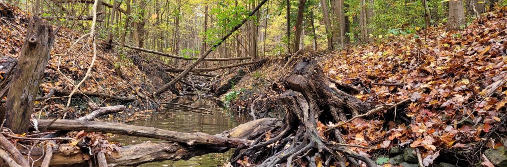
The geomorphology of a stream examines how natural and human factors have shaped its form and function over time. Erosion can affect the path a stream follows (form) and the aquatic and terrestrial habitats the stream supports (function). Erosion results in gradual changes to the form and function of the stream and stream bed. Significant changes to water levels contribute to increased erosion.
During storm events, rainwater or snow melt runoff enters underground pipes via drains and catch basins on streets and in parks and is discharged from storm sewer outfalls into watercourses that flow to Lake Ontario. At times these flows can be high, resulting in erosion damage. High flows from past storms have caused substantial erosion damage to sewers and watermains located in and near the City’s ravines and watercourses.
This erosion damage can:
To learn more about erosion in streams and rivers, view the Understanding Streams information slides.
The map below shows the location of Newtonbrook Creek and Blue Ridge Creek and the area under study.
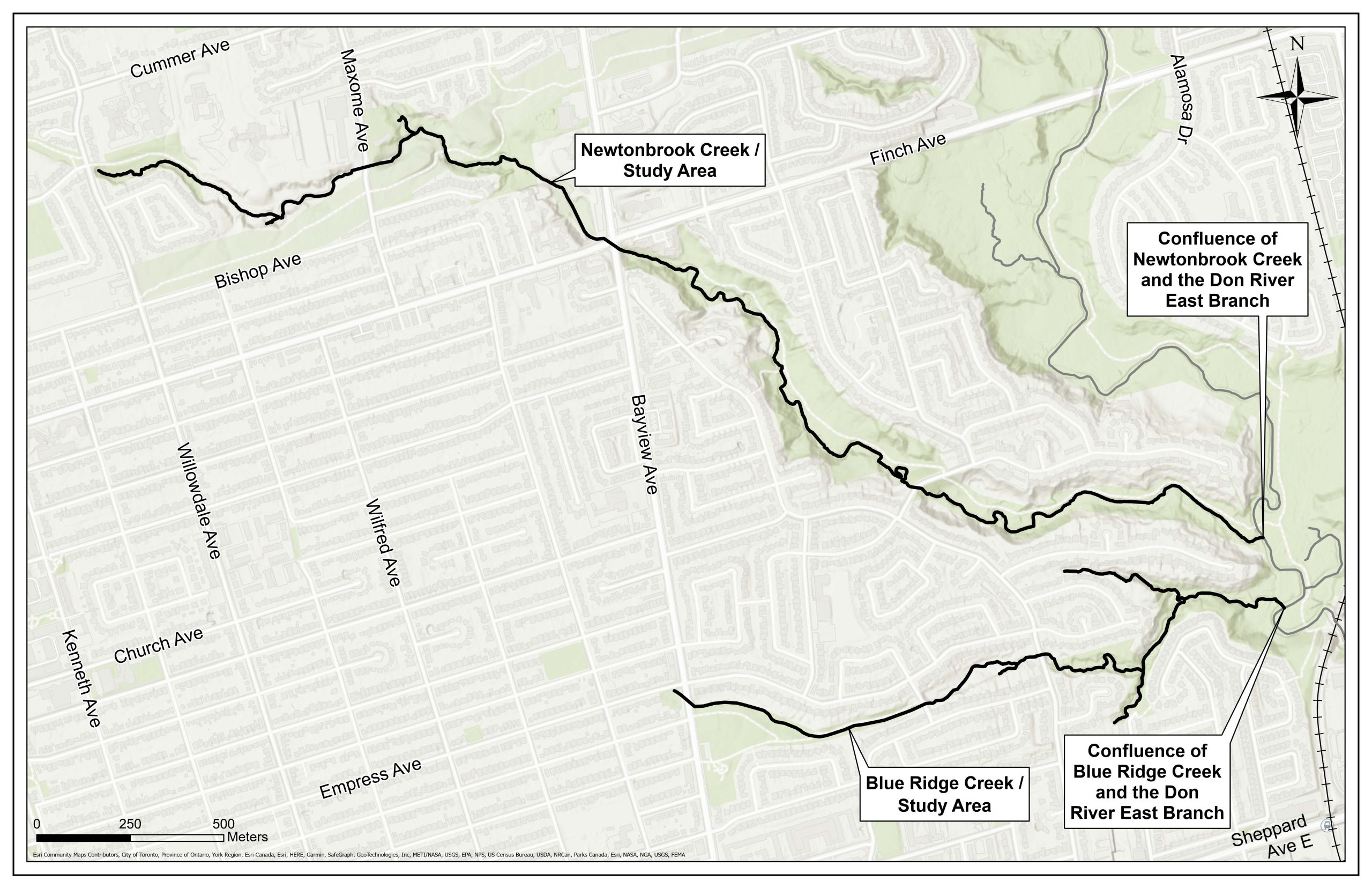
The study area is made up of approximately four kilometers along the length of Newtonbrook Creek from Willowdale Avenue south of Cummer Avenue to its confluence with the Don River west of Leslie Avenue, and two kilometers along the length of Blue Ridge Creek from Bayview Avenue East to its confluence with the Don River.
While we aim to provide fully accessible content, there is no text alternative available for some of the content on this page. If you require alternate formats or need assistance understanding our maps, drawings or any other content, please contact us at 416-338-2985 or email newtonbrook@toronto.ca.
The purpose of the study was to develop a Geomorphic Systems Master Plan (GSMP) for Newtonbrook Creek and Blue Ridge Creek. The study will satisfy the following requirements of a Master Plan. The study
The study did not examine trail conditions or recommend improvements to trails, forestry or ravine amenities.
The study was carried out following the requirements of the Municipal Class Environmental Assessment (MCEA) Master Planning process, where the level of investigation, consultation and documentation are sufficient to fulfill the requirements for Schedule B projects identified within the Master Plan.
Steps in the MCEA study process:
Following a successful review period the Master Plan will be complete. Projects identified within the Master Plan may proceed to detailed design and implementation and will be included in the City’s stream restoration and erosion control program. Implementation will be prioritized across all GSMPs city-wide.
The Master Plan report is shared with the City’s Parks, Forestry and Recreation division and TRCA for coordination and collaboration to advance long-range plan.
The Master Plan identifies projects to be implemented in the immediate term (2 – 5 years), medium term (5 – 10 years) and long term (beyond 10 years). The timeline for long term projects will be determined by several factors including the condition of the existing erosion control structures, which, overall, are currently in a reasonable state of repair.
The City will issue future notification prior to any construction.
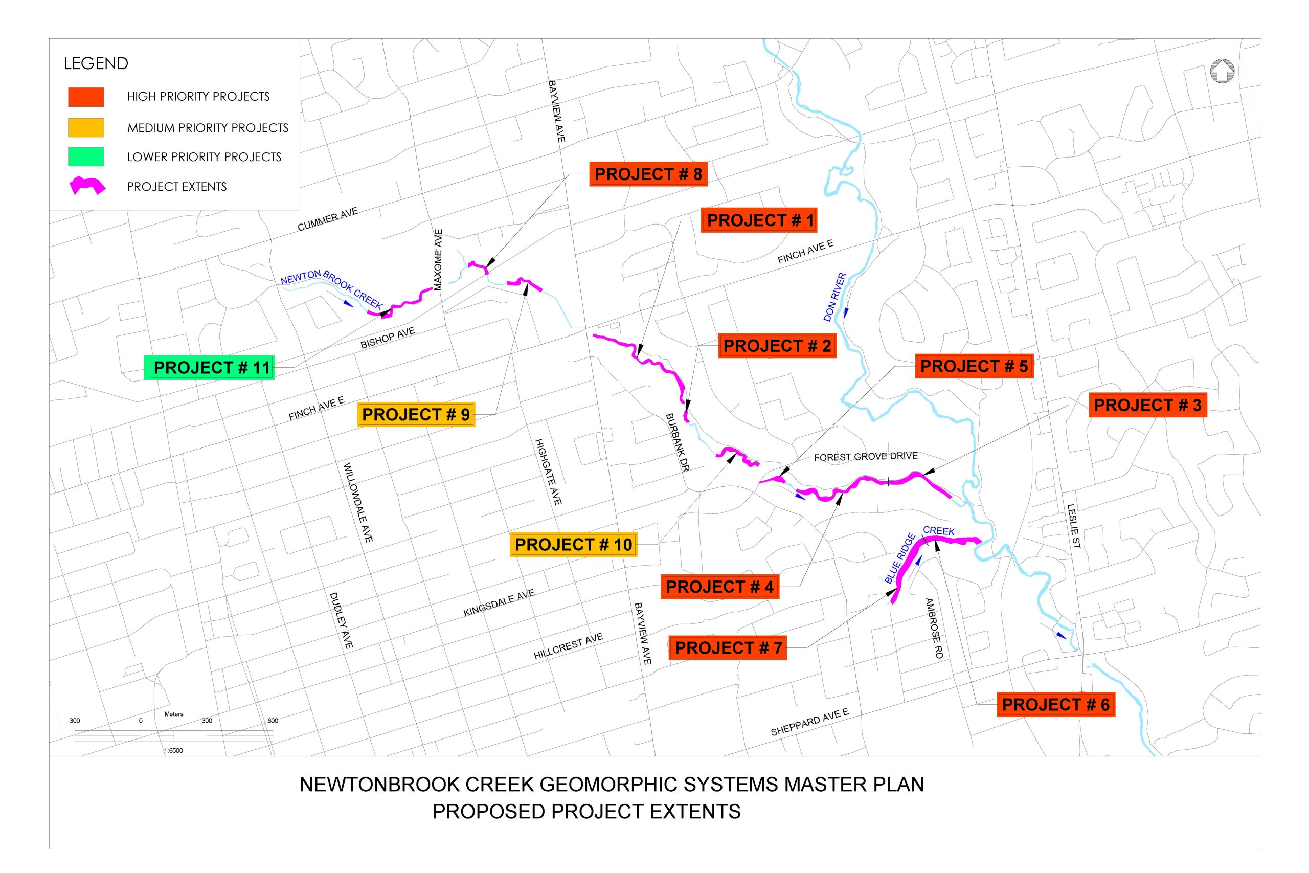
The study area includes 72 City of Toronto water, stormwater and sanitary sewer infrastructure sites. The level of risk due to erosion was assessed for all sites, with 24 priority sites elected for improvement. These 24 high and very high risk sites were group into 11 projects due to their proximity for further assessment as part of the study.
The level of risk caused by erosion is based on a technical assessment characterizing risk probability (time to exposure), existing bank protection, and risk severity, should damage occur.
Very Low Risk Sites
Infrastructure and site conditions are very stable
Low Risk Sites
Medium Risk Sites
High Risk Sites
Very High Risk Sites
The Newtonbrook Creek information deck provides details on the risk assessment for each site.
The following alternative solutions for natural channel design were evaluated for infrastructure at risk of erosion throughout the study area:
Alternative 1: Do Nothing
No planned interventions in the stream, continued monitoring, the sanitary sewer crossing will continue to be at risk of failure due to channel downcutting
Alternative 2: Local Works
Channel engineering works less than 150 metres in length (minor local adjustment to the creek bed), bank erosion protection (armourstone walls), outfall restoration
Alternative 3: Sub-Reach Scale Works
Natural channel design in channel length greater than 150 metres, channel realignment at select locations, outfall restoration, bank erosion protection (armourstone walls, vegetate buttresses and plantings)
Alternative solutions are evaluated per project, based on a range of criteria:
The following recommended solutions were made based on a risk assessment and evaluation of Alternative Solutions:
Projects 3, 5, 8, 9
Recommended solution: Local work less than 150 metres
The recommended solution for these projects:
Projects 1, 2, 4, 6, 7, 10, 11
Recommended solution: Sub-reach greater than 150 metres
The recommended solution for these projects:
Future implementation of the recommended projects requires:
The Master Plan Report is available for a 30-day review period form January 13 until February 12, 2026. See the Newtonbrook Notice of Completion for details.
A public site walk and drop-in information was hosted on Wednesday October 18, 2023. Members of the public were provided an overview of the study, had the opportunity to review recommended solutions ask questions and provide feedback.
Consultation Materials
To receive study updates by email, contact newtonbrook@toronto.ca and indicate that you would like to be added to the mailing list.