To ensure the interests of the City are met and to adequately assess the technical aspects of your proposal, the City requires submission of a number of information items with your application. This page provides definitions and detailed descriptions of the plans, reports and studies the City may require in order to assess development proposals and the completeness of development applications.
Please note that not all of these requirements will apply to your proposal and that the level of detail required for these reports and studies varies widely. Your pre-application consultation meeting will determine the requirement for, and scope of, any plans, reports and studies that must be provided with your initial submission to consider your application complete.
Terms of Reference are being prepared for the following reports/studies. In the interim, the requirements and details of these plans/reports/studies, should you need one, can be addressed during your pre-application consultation meeting.
Effective June 5, 2024
A sample board of select exterior materials may be requested during development review.
1:50 Scaled Detailed Colour Building Elevations are required for developments 5 storeys or higher for the following application types:
Terms of Reference are being prepared for this study. In the interim, the requirements and details of this study should you need one can be addressed during your pre-application consultation meeting.
Alternately, please refer to the City of Toronto Accessibility Design Guidelines.
Effective September 12, 2024
In 2017, Toronto City Council enacted By-law 1432-2017, regulating the use of lands in the vicinity of St. Michael’s Hospital and The Hospital for Sick Children.
On January 26, 2024 the Minister of Municipal Affairs and Housing issued O.Reg.10/24, a Zoning Order for the Protection of Public Health and Safety – Toronto Hospital Heliports.
Both instruments ensure safe operations of aircraft and air ambulance services to and from St. Michael’s Hospital and The Hospital for Sick Children by imposing restrictions on the heights of buildings, structures, and naturally growing objects so that they do not intrude into the flight paths.
Other federal airport zoning regulations are in place to regulate development to protect flight paths in relation to airports, including Toronto Pearson Airport and Billy Bishop Airport.
An Aeronautical Report will be required for any proposed development on sites located within the St. Michael’s Hospital, The Hospital for Sick Children, Toronto Pearson Airport, and Billy Bishop Airport flight paths for the following application types:
Where it can be ascertained that the proposed height of a development will not pierce the surface limits of the relevant flight path without an Aeronautical Report, this requirement may be waived at the sole discretion of the City.
For proposed developments within the above-described hospital helicopter flight paths, the Aeronautical Report should demonstrate compliance with By-law 1432-2017 and Minister’s Zoning Order O.Reg. 10/24. Visit City’s Applications for Development within the Hospital Helicopter Flightpath for more information.
For proposed developments within Toronto Pearson, Billy Bishop Airport, or any other flight path, if any, the Aeronautical Report should demonstrate compliance with the applicable federal airport zoning regulations.
Note: Terms of Reference are being prepared for this report. In the interim, the requirements and details of this report, should you need one, can be addressed during your pre-application consultation meeting or upon request.
Effective January 9, 2023
An Air Quality and Odour Study is a technical report that provides a written description of the impact of air emissions, including odour and dust, by the surrounding environment on the proposed development as well as mitigation measures to reduce any negative impacts.
The Study:
This Air Quality and Odour Study is to be prepared, on behalf of the applicant, by a consultant that is either an Air Quality expert or a qualified Professional Engineer.
If the development includes a sensitive land use, the proximity of the sensitive land use to any industrial land use should be evaluated. Refer to D-1-3 Land Use Compatibility: Definitions for classification of sensitive land use and industrial land use. Proximity to industrial land uses should be assessed based on the principle of potential influence areas outlined in the Ministry of the Environment and Climate Change (MOECC) Guideline D-6 “Compatibility between Industrial Land Uses” (the Guideline). The Guideline provides a classification system for industrial facilities, from Class I (facilities with the lowest potential for emissions) to Class III (facilities with the highest potential for emissions).
Nearby industrial land uses (within 1000 metres of the proposed development) should be classified according to this classification system and listed in the Air Quality and Odour Study Study. If the separation distance for one or more nearby industrial land uses is lower than the potential influence distance in the Guideline (70, 300, and 1000 metres for Class I, II, and III industrial uses respectively), then further assessment is required. Note that separation distance should be evaluated from property line to property line unless ancillary land uses or mandatory setback distances are present, in which case these may be included in the separation distances.
If further assessment is required due to the proximity of industrial land uses, the consultant shall obtain a copy of any Environmental Compliance Approvals (“ECAs” – previously known as Certificates of Approval) issued to the subject industrial facilities.
If these ECAs include an air emission component, the consultant shall obtain a copy of the emission summary table from each of the industrial facilities. These emission summary tables should be examined to evaluate the presence of common contaminants emitted by nearby industrial facilities. If the combined facility ground-level concentrations of any particular compound exceeds 100% of the MOECC limit for that compound, further analysis with respect to that contaminant may be required to assess cumulative impacts from multiple facilities. This analysis could include dispersion modelling or long-term air sampling and monitoring in advance of application approval. The applicant should submit a proposed monitoring plan for the City’s approval, and finalize the plan in consultation with the City. The applicant should not commence monitoring until the City has approved the monitoring plan.
If the nearby industrial facilities have operations that emit odours, as determined by the character of the operations or the presence of odour assessment in the ECA, a community odour survey in the vicinity of the proposed development is required. The applicant should submit a proposed community odour survey plan for the City’s approval, and finalize the plan in consultation with the City. The applicant should not commence the community odour survey until the City has approved the plan.
Additionally, if nearby facilities have significant levels of particulate matter emissions, or a fugitive dust management plan is a condition in the ECA, or the industrial land use contains unpaved roads or outdoor storage piles, a dust monitoring program may be required as part of the Air Quality and Odour Study. Official Plan Section 2.2.4 (Policy 5) requires that development adjacent to or nearby Employment Areas should be appropriately designed, buffered and/or separated from industries as necessary to mitigate adverse effects including those from dust, odour, and air emissions so as to promote safety and security.
An Air Quality and Odour Study may be required for the following planning application types:
Official Plan Section 2.2.4 (Policy 5) requires that development adjacent to or nearby Employment Areas should be appropriately designed, buffered, and/or separated from industries as necessary to mitigate adverse effects including those from air emissions, odour, and dust to promote safety and security.
Official Plan Section 3.4 (Policy 21) requires major facilities such as airports, transportation/rail infrastructure, corridors and yards, waste management facilities and industries adjacent to sensitive land uses such as residences, educational and health facilities to appropriately design, buffer, and/or separate the facilities and uses from each other to prevent adverse effects from air emissions.
To assist in identifying potential impacts and mitigative measures, the applicant may be required to prepare an Air Quality and Odour Study in accordance with guidelines established for this purpose. The proponent will be responsible for implementing any required mitigative measures.
In addition to sensitive land uses, the Official Plan in Section 4.6 policies 6 and 7 deals with mitigation of the effects of air emissions among other things in order to create competitive, attractive, highly functional Employment Areas.
During Pre-Application Consultation, City Planning staff will work with the applicant’s consultant to determine if such a Study is required and, if so, the specific requirements of the Study, based on the nature of the proposed application and the context of the study area.
The Study should include, but is not necessarily limited to:
Note: The City of Toronto may wish to hire an outside consultant, at the expense of the applicant, to peer review selected technical reports submitted in support of a development application where there is no in-house expertise available).
Effective May 31, 2023
The Arborist Report is a technical document that provides detailed information, including the location, species, size and condition, of individual trees and associated significant vegetation (i.e. shrubs) on private and public lands (such as the boulevards and parks) that may be affected by a proposed development. The Arborist Report assesses all proposed tree and vegetation impacts and identifies tree care methodology along with any specific treatment details to protect and preserve trees before, during and after construction.
A certified arborist professional is required to prepare the report. A certified arborist professional generally includes:
An Arborist Report will be required for the following planning application types where the property contains existing regulated trees and/or regulated trees are located within six metres of all property lines (or all trees within 12 m from all proposed disturbance areas for sites regulated by the Ravine and Natural Feature Protection By-law, Municipal Code Chapter 658). The planning application types are:
The Arborist Report aides the development of a Tree Preservation Plan which is required to be submitted concurrently. The Arborist Report is a requirement of Schedule 3 of the Official Plan. Various policies of the City’s Official Plan seek to preserve the long-term growth and increase of the amount of healthy and mature trees within the City. These principles are also reflected in the City’s Toronto Green Standards and various City Council-approved initiatives. The City of Toronto Municipal Code also establishes authority in regulating trees and ravine areas of the City, including the Tree By-law (Chapter 813), Ravine and Natural Feature Protection By-law (Chapter 658), and the Parks By-law (Chapter 608).
An archaeological resource assessment identifies and evaluates the presence of archaeological resources also known as archaeological sites. Archaeological resources or sites include the physical remains and contextual setting of any structure, event, place, feature, or object which, because of the passage of time, is on or below the surface of the land or water, and is important to understanding the history of a people or place.
Since 2004 the City of Toronto, Heritage Preservation Services (HPS), has been developing an archaeological management plan (AMP) to govern when archaeological assessments are required within City lands. This planning tool is a predictive model and provides information on which lands are likely to contain archaeological resources and should be subject to an assessment.
An archaeological assessment is required for the following application types if the property is on the City’s database of lands containing archaeological potential:
Whether a property has archaeological resource potential can be confirmed at the searchable database TO maps. Use the map’s legend and activate the archaeological potential tab to search property addresses directly.
An archaeological assessment may also be required if a property is identified on the City of Toronto’s Inventory of Heritage Properties as part of the Heritage Impact Assessment process (See terms of reference for Heritage Impact Assessments).
An archaeological assessment is required on lands that hold archaeological potential in order to ascertain the presence or absence of archaeological resources. If these resources are present, the archaeological assessment will evaluate the significance of these resources and outline measures to mitigate the impact of development on these resources. Mitigation measures include on-site preservation and avoidance of the archaeological site entirely, as per the City of Toronto’s Official Plan, 10 (b), or alternatively the site is subject to full documentation and removal.
The archaeological assessment will inform the review of an application by City Planning staff. The rationale for the requirement to provide an archaeological assessment is based on the findings of the City of Toronto’s archaeological management plan together with the legislative authority stemming from: the Ontario Heritage Act, Section 2 (d) of the Planning Act, Section 2.6.3 of the Provincial Policy Statement (2005), Section 3.1.5 Heritage Resources of the City of Toronto’s Official Plan, the Environmental Assessment Act (1997), the Environmental Protection Act, O.Reg.359/09, the Aggregate Resources Act, and the Cemeteries Act.
An archaeological assessment is divided into stages 1-4, as per the Ministry of Tourism and Culture 2011 Standards and Guidelines for Consultant Archaeologists for land-based archaeology.
The assessment must adhere to both the Standards and Guidelines for work conducted within lands which comprise the City of Toronto.
Background Study and Property Inspection – The consultant archaeologist reviews the geographical and historical information for lands which are part of the development proposal, and completes a detailed land use study. The land use study is to include a review of historical land use and ownership records (e.g. assessment rolls, census records, commercial directories).
For City of Toronto proposals/projects, a property inspection is mandatory and not optional.
Property Assessment – A field examination takes place which may require either a surface or pedestrian survey or test pit surveys of the subject property. Special conditions such as brownfield properties or deeply buried urban contexts will require alternative strategies and should be discussed with Heritage Preservation Services staff in advance of work. If aboriginal archaeological sites may be encountered during Stage 2 work due to proximity to known archaeological sites in the area or local or oral history, First Nations engagement and consultation will be required at Stage 2 assessment. Special conditions should be discussed with HPS staff prior to the assessment being undertaken.
Site Specific Assessment – When potential archaeological sites are identified during the course of Stage 2 work, additional detailed information is obtained through a Stage 3 assessment. This will delineate and evaluate the significance of the site found and make recommendations for appropriate mitigation measures. For some sites, no further work will be recommended at the end of Stage 3. First Nations engagement and consultation will be required should aboriginal archaeological sites be discovered at Stage 3. The City of Toronto’s Official Plan Policy 10 c) states that “indigenous cultural remains should be identified, recorded, protected and preserved” rather than be subject to full archaeological assessment including documentation and removal.
Mitigation of Development Impacts – Stage 4 includes implementing long-term protection strategies for archaeological sites to be impacted by the project. If after full consultation with the City of Toronto, the proponent, the Ministry of Tourism and Culture, and the consultant archaeologist, protection of the site cannot be achieved, the consultant archaeologist may excavate the site to fully document features and remove artifacts prior to further soil disturbance activities taking place on site.
Provide two colour copies of all archaeological assessments completed, the Borden registration form if filed, and an electronic copy of all reports in PDF format.
Should the archaeological consultant recommendations include a program of archaeological monitoring during the construction process, an archaeological monitoring and mitigation strategy will be required as a condition of development approval.
Should the assessment result in the discovery of an archaeological site, or significant archaeological resources, the proponent will be required to prepare and implement a commemoration and interpretation strategy as a condition of the development approval.
Archaeological assessments are to be completed together with any associated mitigation well in advance of any soil disturbance. Archaeological assessments cannot be completed during certain times of the year (i.e. snow cover, frozen ground, excessive rain/wet conditions).
Architectural Control Guidelines are a written and graphic manual providing division direction regarding the achievement of the built form and public realm policies contained in the Built Environment section of the Official Plan (Section 3.1). The Guidelines are a combination of text, plans, illustrative sketches and photos, sections and comparative models or examples that inform the proponent, public and City about the built form, landscape and structures on private lands within new neighbourhoods.
A land owner may choose to use a “Control Architect Process” to achieve the City’s built form objectives and control the quality of work in each phase. Discussions about Architectural Control Guidelines should be held with the Planner and Urban Designer in pre-application consultation meetings to determine the applicability of this form of guideline to the site. This is particularly important on large sites that will take many years to complete.
The Guidelines are written for the Control Architect to use in evaluating the design of buildings and associated landscapes within the area. The Guidelines may be an alternative to individual site plans (for single lots, and building types not normally processed through Site Plan Approval) in parts of the City where it is important for new buildings to blend with existing communities/neighbourhoods, to advance the emerging character of a new or redeveloping community/neighbourhood. The Control Architect Process and the use of the Architectural Control Guidelines is a standard process for the development industry within the GTA.
Architectural Control Guidelines may be required for the development of large sites for:
The requirement for, and scope of, the Architectural Control Guidelines should be discussed with the Planner and Urban Designer in pre-application consultation meetings. Architectural Control Guidelines will likely be required for applications incorporating large land areas with a number of parcels or phases within a development, new streets and parks and sites of civic prominence.
The Architectural Control Guidelines are approved by the municipality and the landowner and are implemented through an Architectural Design Control Process that is managed by the municipality and paid for by the Applicant. They address built form matters and may exceed the provisions of the Planning Act by addressing architectural matters such as materials, colours and detailing in addition to siting and building massing issues. The Guidelines depend upon agreement between the City and the developer regarding the importance of a high quality of architectural design.
When administered properly, the Architectural Control Process can streamline future planning approvals by clarifying design expectations for development and minimizing City staff involvement. In the appropriate agreement (i.e., subdivision agreement) requirements that building permits not be issued for lots under architectural control in advance of certification (in a form acceptable to the City) from a “Control Architect” will be included.
A “Control Architect” administers the Council approved Architectural Control Guidelines on behalf of the City and the developer. The Control Architect is an independent professional responsible for conducting a comprehensive review of each lot to ensure that siting, built form, materials, colours and landscaping, among other things, are in compliance with the approved Guidelines. To avoid potential conflict of interest, it is important that the Control Architect and the Design Architect not be the same individual or firm.
The Guidelines will address the whole of the new neighbourhood or plan of subdivision. Specific types of development, development blocks and/or built form may be specifically omitted at the discretion of the City. Where a contiguous tract of land is divided into several subdivisions or development sites, use of a comprehensive set of Guidelines will be encouraged to achieve architectural consistency within a larger neighbourhood.
The Guidelines will be flexible to accommodate change as it occurs while maintaining intact the essential urban design ideas.
Architectural Control Guidelines should be applied to development as a condition of subdivision or equivalent development approval process. The applicant should develop draft Architectural Control Guidelines as early as possible in the planning process with active participation by City staff. The Architectural Control Guidelines may be attached to or referenced by the applicable subdivision/development agreement. Approval for minor revisions to the Guidelines may be delegated to staff. Where major revisions are needed, Council approval may be required.
Architectural Control Guidelines will form part of a subdivision agreement and will consist of the following components (though modification may be required to address the requirements of individual neighbourhoods and districts):
More detailed design direction for the following:
Additional built form matters may be included to address contextual and site specific conditions. These matters may include, but are not limited to, cultural or natural heritage, noise attenuation, height restrictions and topographic conditions.
Final Guidelines will include:
Effective March 14, 2025
Published September 15, 2025
As of March 14, 2025, OPA 778 is in force. New Avenues policies apply to all applications received on or after this date, and the Avenue Segment Review is no longer a required component of a complete application.
For applications that are subject to a site-specific appeal of OPA 778—whether submitted before, on, or after March 14, 2025—the former Avenues policies continue to apply unless the appeal is withdrawn by the appellant and confirmed with the City Solicitor and the Tribunal. In these cases, the former Avenue Segment Review Terms of Reference, set out below, remain applicable:
The Avenues as shown on Map two of the Official Plan are important corridors along major streets where reurbanization is anticipated and encouraged. Contextual and appropriate reurbanization of the Avenues will be achieved through the preparation of Avenue Studies. These studies will be undertaken by the City and will set out the terms of reurbanization and include urban design guidelines and a comprehensive zoning by-law for the Avenue. Due to the significant number of Avenues, the program to complete all the studies will take several years. In the meantime, development in Mixed Use Areas on an Avenue prior to the completion of an Avenue Study may proceed provided the applicants of such proposed development undertake an Avenue Segment Review.
As described in policy 2.2.3.3b of the Official Plan, Segment Reviews are required to:
For a more fulsome explanation of the Avenues and the relevant development policies, applicants should refer to Section 2.2.3 of the Official Plan.
The Official Plan requires that all applicants submit an Avenue Segment Review as part of their Official Plan Amendment and/or Zoning By-law Amendment application package for any proposed development in the Mixed Use Areas on Avenues where an Avenue Study has not yet been completed, and where the Avenues & Mid-Rise Study does not apply.
For applications within areas where a Segment Review has been previously submitted a full Segment Review may not be required. This depends however on when the previous Segment Review was completed, and the applicant’s ability to demonstrate that their proposed development would not alter the findings of the previous Segment Review(s) and that the proposed development would continue to establish a positive precedent for the rest of the Avenue Segment. In these scenarios applicants are encouraged to consult with City Planning staff as early in the development approval process as possible to determine if a full Segment Review is required and the elements to be studied.
It should also be noted that applications on sites designated Apartment Neighbourhood Areas, do not require a Segment Review but applicants are expected to discuss and address Avenue policies in the associated planning rationale. Further, applications on sites designated Employment Areas and/or on sites designated Mixed Use Areas proposing employment uses without a residential component may not be required to submit a full Segment Review. As with the above, applicants with these scenarios are encouraged to consult with City Planning staff as early in the development approval process as possible.
The overall goal of the Avenue Segment Review is to ensure that the proposed development will establish a positive precedent for the future reurbanization of the Avenue, with particular regard to building form, massing and intensity. Acceptance of the review is dependent upon the Segment Review reasonably demonstrating that the proposed development will have no adverse impacts and will establish a positive precedent for the Avenue Segment that is subject to the review. A clear indication as to how the policies of Section 2.2.3.3b) of the Official Plan have been addressed, along with the other Avenue policies and other relevant policies of the Plan is required.
The Official Plan identifies criteria Avenue Segment Reviews are to meet in policy 2.2.3.3b) and specific details regarding content can be found in the sidebar on page 2-16 (Avenue Studies and Development Applications). Although the sidebar refers to the contents of an actual Avenue Study it does state that an application for development on a site where an Avenue Study has not yet been completed will be evaluated through a process that mirrors that of an Avenue Study. In other words, a Segment Review may cover similar study topics but would not produce a specific set of development and design guidelines or an implementing zoning by-law beyond the development site.
Final determination of the boundaries and content of a Segment Review will be determined by City Planning staff based on a review of the area’s context and from discussions with the applicant’s consultant. During pre-application consultation, City Planning staff will work with the applicant’s consultant to determine the specific requirements of the Segment Review based on the nature of the proposed application and the context of the study area.
Generally speaking, the Avenue segment to be reviewed is defined by the context of the area and/or how similar the subject site is to other properties and land uses along the segment. Boundary indicators can include but are not limited to:
At a minimum the Segment Review should address an area large enough that the impacts of the proposed development, including the precedent setting (i.e. cumulative) impacts, can be assessed.
In addition to a hard copy, applicants should also submit a PDF version of their Segment Review.
The Block Context Plan is prepared in cooperation with adjacent landowners that shows how the physical form of the proposed development fits within the existing and planned context and conforms to the policies of the Official Plan and implementation tools including site specific and other guidelines.
The Block Context Plan may be required if, but not limited to, one of the following criteria are met:
The Block Context Plan will be integrated with but separate from the Planning and Urban Design Rationale, and other required studies including transportation studies, community service studies, shadow, wind studies and 3D perspective views.
The Block Context Plan provides a conceptual and comprehensive idea of development on the block and a framework to evaluate proposed development. It will inform Official Plan Amendments, rezoning, plans of subdivision and other planning processes. The Block Context Plan will illustrate and analyze the development proposal in both existing and planned context for an area larger than the development site itself, regarding the layout and design of public streets and other pedestrian and cycling connections, parks and open spaces and built form issues such as building type, location, organization and massing.
During pre-application consultation, City Planning staff will work with the applicant’s consultant team to determine if a Block Context Plan is required and the specific requirements of the Plan, based on the nature of the proposed application and the context of the application. The area of the study generally will be the rest of the block where the application is considered as well as all parcels across each of the streets on the perimeter of that block. The boundary of the study area and variations of the study area will be discussed with the applicant in pre application meetings.
The Block Context Plan will include clear writing, supporting drawings, diagrams, plans, sections and three dimensional massing images, and perspectives as appropriate.
The plan will include an inventory, assessment and understanding of the physical features of the existing site context including recently approved and active development applications.
The study will include an inventory of planned context including land use designations, existing zoning envelopment and other relevant planned context from site specific or city wide guidelines including Tall Building, Midrise Buildings and Townhouse and Low-Rise Apartment Buildings guidelines, streetscape manual, DIPS, etc.
The plan will demonstrate how the proposal is in conformity with OP policy, anticipates community needs and contributes to good planning and urban design.
Items to be addressed in the Block Context Plan include but are not limited to:
Effective May 11, 2023
A Community Services and Facilities (CS&F) Study may be required to identify existing and future levels of social infrastructure required to support growth. The purpose of the CS&F Study is to ensure that up-to-date information regarding CS&F is provided to inform recommendations and decision-making with regards to required new, expanded, or improved CS&F to ensure coordination and availability of such CS&F along with proposed growth as it occurs, in support of the Provincial Planning Statement and Official Plan policy direction.
CS&F Studies may be required in relation to the following planning applications for developments generally containing 150 to 200 or more residential units:
The City Planning Division will determine whether a CS&F Study is required for one or more of the above applications with regard for the following:
At both the provincial and municipal level, planning policy recognizes CS&F, as integral and foundational community elements within local communities to support the achievement of complete communities.
Section 3.2.2 of the Official Plan addresses the quality of life and well-being of Toronto’s communities. The Policies of Section 3.2.2 of the Official Plan calls for adequate and equitable access to community services and local institutions, and sets out a policy framework that, among other things, encourages the inclusion of community service and facilities as part of private development. Official Plan Policy 2.3.1.7 also identifies that community and neighbourhood amenities will be enhanced where needed by improving and expanding facilities, creating new facilities and adapting existing services to changes in the need of the neighbourhood. The Official Plan also directs the evaluation of adequacy of community services, facilities and local institutions to support new development in growth areas such as the Downtown, Centres, Avenues, Regeneration Areas, Secondary Plan areas and other areas of the City where new neighbourhoods will be established with a comprehensive planning framework that reflects City-wide goals as well as the local context that includes the provision of CS&F.
The intent is to coordinate new development with the provision of CS&F (whether new, expanded or improved) to be phased into an area with the timing in line with approved future residential or in some cases commercial development to be available to the future residents to support complete communities. This will allow for communities to have access to CS&F as they emerge, therefore contributing to the resident’s quality of life.
CS&F Studies will be prepared by the applicant, their agent or consultant. The required contents of the CS&F Study are the responsibility of the applicant that meet the terms of reference. The applicant must confirm and finalize what components of the terms of reference are to be satisfied based on the application type and information known regarding CS&F in a given area. The applicant should obtain this information from the assigned City Planning Policy planner prior to the initiation of the CS&F Study and prior to the submission of an application to the City.
City Planning Policy staff will provide a letter of introduction to help consultants who are undertaking CS&F studies, to access staff, information and data sources of various City divisions, public agencies and social service providers. A list of relevant plans, policies and studies has been provided in Section 3 of this terms of reference, Facilities Inventory and Analysis by Sector. Staff may also provide additional documents for consideration as relevant.
The contents of a CS&F Study include, but are not limited to, the following:
1. Demographic Profile of the Study Area
The demographic profile should provide the following key statistics from the most recent Federal Census data available at the time of the study. The profile should show change (if any) over time and identify key trends compared to the City of Toronto for the following:
| Key Demographic Categories | Data and Analysis |
| Total Population and Population Change | Population change from last census |
| Population as a percentage of total by age cohort (0-14 children); (15-24 youth); (25-64 working age); (65+ seniors) | |
| Percentage of the population specifically age 0-4 years to determine early years child care space generated by development | The calculation is (Population estimate) X (% of children ages 0-4) X 50%.
|
| Percentage of the population living alone | |
| Household size | Family composition, including families by type, number of children, private household by type and size |
| Median household income | |
| Housing tenure-percentage of apartment buildings >5 storeys and percentage of single detached units | Housing includes: occupied private dwellings by structural type, period of construction and tenure |
| Percentage Immigrated by most recent period of immigration (last 5 years) | Immigration population, including population by period of immigration, recent immigrants by selected countries of birth or the most recent census period (top five countries), number of immigrants in neighbourhoods in the Study Area and number and type of language spoken, population mobility status |
| Labour force including labour force by occupation and labour force by industry; and | |
| Educational Attainment | Socio-economic characteristics (highest and lowest level of education attained by residents in the Study Area, labour force participation |
2. Development Activity
Identify recently approved and active development applications within the CS&F Study Area, summarizing:
3. Facilities Inventory and Analysis by Sector
The Facilities Inventory and Analysis by Sector should include a map (or maps) showing services and facilities serving the study area in which the development application is located. The inventory and analysis should identify facility and capital needs described in approved Facilities Master Plans, Implementation Strategies, existing City CS&F studies and reports, and policy documents for each of the five sectors described below. It should discuss the anticipated impact of the proposed development on demands and service needs or gaps within the Study Area.
Community services and facilities serve the needs of the local population and support complete communities. CS&F study inventories should include (but are not limited to) the following sectors:
3.1 Elementary and Secondary Schools
Provide capacity, full time enrolment and utilization rates for schools in the Study Area for both the Toronto District School Board and Toronto Catholic District School Board, as well as projected number of elementary and secondary students from the proposed development. Please contact the school boards for most recent and updated numbers and estimated students. Each school board web site contains a list of schools and locations.
3.2 Public Libraries
Provide a summary of Toronto Public Libraries (TPL) within the service radius of the proposed development, and any capital needs identified in the TPL Facilities Master Plan for those branches. The primary service area of a neighbourhood branch library is a 1.6 kilometre radius, and District branches serve a 2.5 kilometre radius.
A listing of all libraries is included on the TPL Web page and includes a description of collections, opening hours, location and features such as WIFI and computer workstations:
The TPL Facilities Master Plan (FMP) was completed in 2019 with consideration of current planning work being undertaken across the City and related future growth. The Plan sets out TPL’s capital investment priorities to 2028, as well as longer term requirements (30-year roadmap) to account for planning.
3.3. Child Care Centres
Provide a full listing of licenced child care centres located within the Study Area, overall capacity and vacancies, and indicate if each centre accepts a fee subsidy. Also provide the estimated number of child care spaces resulting from the proposed development. The calculation is (Population estimate) X (% of children ages 0-4) X 50%.
The Council approved Toronto Licensed Child Care Growth Strategy (2017-2026) is the key strategic framework to guide growth and has a vision to serve 50% of children aged 0 to 4 years by 2026. Toronto Children's Services web page contains a list of licensed Child Care Centres including capacity and whether fee subsidy is provided.
3.4. Community and Recreation Centres; Arenas; and Swimming Pools
Provide a full listing of public Community and Recreation Centres, arenas and swimming pools in the Study Area. The Parks Forestry and Recreation Facilities Master Plan (PFR FMP) establishes a Community Recreation Centre (CRC) City Wide Service provision level of 1 CRC per 34,000 within a 2 to 2.5 KM radius.
The Council approved Parks, Forestry and Recreation (PFR) Facilities Master Plan FMP (2019-2038) guides investment in parks and recreation. This plan should be used to determine if any capital improvement investment has been targeted towards the Study Area.
An implementation strategy was adopted by Council in 2019 to prioritize and provide timelines to recommended facility projects across the city.
Community Recreation – Part of Parks, Forestry and Recreation this Division provides a list of community centres and other recreational facilities including pools, lawn bowling, ice rinks and parks.
3.5. Human Services
Provide a full listing of Human Services facilities in the Study Area. Human Services are non-profit community organizations that operate out of various spaces and facilities. This listing should identify the organization name and type (e.g. employment services, newcomer/settlement services etc.), location, and whether the facility within the study area serves the local population and/or is a district or regional office.
These organizations can be found on the Toronto 211 web page.
For further information please contact:
Deanna Chorney
Manager, Policy Strategic Initiatives, Policy & Analysis Division, City of Toronto
communitypolicy@toronto.ca
A technical report that provides a written description of the land use compatibility of sensitive land uses, including residential uses, where permitted or proposed outside of and adjacent to or near to Employment Areas or within the influence area of major facilities.
The report will identify any existing and potential land use compatibility issues and will identify and evaluate options to achieve appropriate design, buffering and/or separation distances between the proposed sensitive land uses, including residential uses, and nearby Employment Areas and/or major facilities. Recommended measures intended to eliminate or mitigate negative impacts and adverse effects will be addressed in the applicant’s Planning Rationale where one is required.
This report will be used to assist City Council in making its decision concerning the proposed sensitive land uses, including residential uses, and will be peer reviewed by the City at the cost of the applicant.
The report:
The Land Use Compatibility/Mitigation Study is to be prepared on behalf of the applicant by a Consultant (or Consultants) that is/are fully accredited, qualified and/or certified in the relevant matters being evaluated and recommended (for example air quality assessments should be performed by an engineer fully accredited in such field, etc.).
A Compatibility/Mitigation Study may be required to support the following applications for sensitive land uses, including residential uses, where permitted or proposed outside of and adjacent to or near to Employment Areas or within the influence area of major facilities:
Official Plan Section 2.2.4 (Policy 5) requires that sensitive land uses, including residential uses, where permitted or proposed outside of and adjacent to or near to Employment Areas or within the influence area of major facilities, should be planned to ensure they are appropriately designed, buffered and/or separated from Employment Areas and major facilities.
Official Plan Section 2.2.4 (Policy 6) refers to the possible requirement of a Compatibility/Mitigation Study in the circumstances identified in Section 2.2.4 (Policy 5). The Compatibility/Mitigation Study will be addressed in the applicant’s Planning Rationale.
During pre-application consultation, City Planning staff will work with the applicant and the applicant’s consultant(s) to determine if such a Study is required and, if so, the specific requirements of the Study, based on the nature of the proposed application and the context of the study area.
The Study should, but not be limited to:
The objective of the peer review is to provide Council with an independent, expert, third party assessment of the potential land use compatibility issues as well as the proposed mitigation measures. The purpose is to assist Council in making fully informed land use planning decisions.
The peer reviewer will provide to the City, at the cost of the applicant of the proposed development, a report that will include the following:
Effective January 2, 2025
A 3D model of the proposed development allows staff to evaluate the physical impacts of the proposal. The model is integrated into the City’s context model and is used to evaluate the impacts of the scale of the proposed development and its sun/shadow impacts. Staff will use the model in context to review the application.
A Building Mass Model is required for all developments, regardless of height, for the following application types:
A Building Massing Model is required to illustrate and review the proposal in its existing context. The requirement for, and scope of this work, should be discussed with the Planner and Urban Designer in their pre-application consultation meeting.
To achieve the goals of Official Plan Policies:
3.1.2.3 “New development will be massed to fit harmoniously into its surroundings and will respect and improve the local scale and character. It will minimize the impact on neighbouring buildings and open space by:
3.1.2.4 “New development should be massed to define the edges of streets, parks and open spaces at good proportion and locate taller buildings to ensure adequate access to sky view, sunlight and appropriate pedestrian level wind conditions for the proposed and future use of those spaces.”
Details for the submission of the Model are as follows:
Preferred:
Acceptable:
If you have any questions regarding digital submissions, please contact your Planner.
Technical concerns may be directed to Graphics & Visualization, Urban Design – City Planning Representatives.
Notice of Proposed Development Application and Public Meeting Sign
To show the proposed ground floor and key elements of the site plan in context, with adjacent street(s) and properties, including site circulation for pedestrians and vehicles, conceptual grades, and proposed hard and soft landscaping on site and on the adjacent street(s) and properties. A streetscape and landscape concept for the space between the proposed building and the curb, on the site and adjacent site, may also be requested.
The Concept Site and Landscape Plan may be required for:
Effective January 2, 2025
To show conceptual grading information for the site and building and their relationship to adjacent and surrounding streets, boulevards and properties, as well as grading of site circulation, and grading relationships for the interior and exterior of building(s). The Conceptual Grading Plan must be prepared by a Licenced Professional Engineer specialized in municipal engineering.
A Conceptual Grading Plan is required for the following application types:
The authority to require this work is provided by the Planning Act, the City of Toronto Act, the Official Plan, the Provincial Planning Statement, and to support Council-adopted policies and programs.
For further information please contact:
Development Engineering, Central Review Unit
Engineering & Construction Services Division, City of Toronto
devengcru@toronto.ca
Effective January 2, 2025
To show how municipal services will be provided to the site and how those proposed services will comply with the City’s policies, guidelines, and standards. The Conceptual Servicing Plan must be prepared by a Licensed Professional Engineer specialized in municipal engineering.
A Conceptual Servicing Plan is required as part of the Servicing Report submitted in support of the following application types:
The authority to require the Conceptual Servicing Plan is provided by the Planning Act, the City of Toronto Act, 2006, the Official Plan, the Provincial Planning Statement, Council-adopted policies, guidelines and standards (e.g., Wet Weather Flow Management Policy, levels of protection under Basement Flooding Protection Program, etc.), the City’s Sewers By-law (Toronto Municipal Code, Chapter 681) and Water Supply By-law (Toronto Municipal Code Chapter 851).
The Conceptual Servicing Plan is a component of the Servicing Report.
Servicing design presented on the Conceptual Servicing Plan must meet all requirements established in the City of Toronto’s municipal engineering design policies, guidelines and standards, including but not limited to, the most recent edition of:
The Conceptual Servicing Plan must also demonstrate compliance with all applicable Provincial legislation (e.g., Ministry of Environment, Conservation and Parks), applicable regulations, and applicable provincial guidelines/procedures, including but not be limited to:
Existing municipal and private infrastructure abutting, downstream of, or within the site including:
Proposed municipal infrastructure abutting, downstream of, or within the site including:
Existing municipal and private infrastructure and abutting or within the site including:
Proposed municipal infrastructure abutting or within the site including:
For further information please contact:
Development Engineering, Central Review Unit
Engineering & Construction Services Division, City of Toronto
devengcru@toronto.ca
The following potable water, storm and sanitary sewer servicing requirements apply to all new development applications in the City of Toronto, excluding residential developments of less than 5 dwelling units. These requirements apply in addition to and separate from any other municipal by-law or legislative requirements, including but not limited to those under the Toronto Municipal Code Chapters 681 and 851 or the Ontario Building Code.
Every point tower shall have its own independent service connection to the municipal potable water and sewer services, including all associated stormwater management facilities. For clarification, this applies regardless of any shared podium structures, common underground parking structures, or anticipated ownership structures (including all forms of condominium ownership). Any podium that provides a base for more than one point tower shall also have its own independent service connection to the municipal potable water, storm, and sanitary sewer services.
Every anticipated standard or common-elements condominium corporation shall have an independent servicing connection to the municipal potable water and sewer services, including all associated stormwater management facilities.
Unless otherwise notified in writing at the time of application, staff will review all townhouse applications on the assumption that they will form part of one standard or one common-elements Condominium Corporation. If any party, including but not limited to the applicant and all subsequent owners of the development, applies for more than one condominium corporation encompassing any or all of the development, different service connections, including revised plans and studies, may be required by the City at the sole cost to the condominium applicant.
Every parcel of land that will be separately conveyable requires its own servicing connection to the municipal potable water and sewer services, including all associated stormwater management facilities. In this situation, each condominium corporation will be considered one parcel of land.
Unless otherwise notified in writing at the time of application, staff will review all commercial and industrial applications on the assumption that they will form part of one parcel of land. If any party, including but not limited to the applicant and all subsequent owners of the development, applies to sever or condominiumize any part of the development, different service connections, including revised plans and studies, may be required by the City at the sole cost to that applicant.
Every building shall have its own independent servicing connection to the municipal water and sewer services, including all associated stormwater management facilities, regardless of any shared podium structures, common underground parking structures, or anticipated ownership structure (including all forms of condominium ownership).
Terms of Reference are being prepared for this study. In the interim, the requirements and details of this study should you need one can be addressed during your pre-application consultation meeting.
In February 2015, City Council approved the Policy for Accepting Potentially Contaminated Lands to be Conveyed to the City under the Planning Act (the Conveyance Policy). The Conveyance Policy updates and consolidates the City’s previous procedures and criteria, including the Peer Review Process, and applies when land is to be conveyed to the City as part of a planning application or where below-grade easements are required for new municipal infrastructure.
The Peer Review Process requires the applicant to submit to the City’s Peer Reviewer documentation regarding the environmental conditions on the lands to be conveyed or below-grade easements. The Peer Reviewers are Qualified Persons (QPs) hired by the City. The environmental work and reporting is to be carried out by a QP hired by the applicant in accordance with the requirements of the Conveyance Policy. The submission is peer reviewed only for the land that is to be conveyed to the City or below-grade easement. This documentation should be submitted to the City in conjunction with the development application or as soon as the requirement for land conveyances/below-grade easements to the City is known.
The owner is responsible for all costs associated with the Peer Review Process, including the City’s administrative fees. The Peer Review Process is administered by the Engineering & Construction Services Division.
The current overall requirements for accepting land conveyances and below-grade easements are detailed in Attachment 1 (Conveyance Policy), and summarized in Table 1, of the Staff Report as approved by City Council on February 11, 2015.
Note: This document is intended as a guidance document only. The Conveyance Policy contains detailed environmental requirements for land conveyances and below-grade easements.
Records of Site Condition (RSCs) filed with the Ministry of Environmental and Climate Change (MOECC) require the property owner to demonstrate that the property meets regulated soil, sediment and groundwater standards.
As a condition of the City’s approval, a submission of a Letter of Acknowledgement of Filing of the Record of Site Condition (RSC) issued by MOECC confirming that the RSC has been prepared and filed in accordance with O. Reg. 153/04 will be required by the City, if applicable.
The Peer Review Process may be required when land is to be conveyed to the City or below-grade easements for new municipal infrastructure are required as part of a planning application.
The Peer Review Process MAY be required for the following planning application types (see Peer Review exemptions below):
The Peer Review process is ALWAYS required for the following planning application types:
There are certain circumstances when land conveyances to the City and below-grade easements are exempt from the Peer Review Process. The following are cases when the Peer Review Process is NOT required (not applicable to Plan of Subdivision applications):
The current overall requirements for accepting land conveyances and below-grade easements are detailed in Attachment 1 and summarized in Table 1 of the Staff Report as approved by City Council on February 11, 2015 (the link is provided in Description section above).
Section 3.4 of the Official Plan implicitly supports the clean-up of contaminated sites for reducing the risks to life, health and safety, property and ecosystem health.
The Council-approved Policy for Accepting Potentially Contaminated Lands to be Conveyed to the City under the Planning Act, February 2015, which updates and consolidates the City’s procedures and criteria for the acceptance of potentially contaminated lands conveyed to the City as a condition of a Planning Act application approval.
For all land conveyances to the City or below-grade easements that are not exempt from the Peer Review Process, the owner of the land must undertake the appropriate environmental site assessment (ESAs), site remediation or risk assessment and the filing of a RSC, if required (see ‘When Required’ section).
All work and reporting is to be completed by the applicant’s Qualified Person (QP), and will be Peer Reviewed by an environmental consultant selected by the City (Peer Reviewer) and paid for by the applicant.
The environmental reports and documents which will be Peer Reviewed by the Peer Reviewer include some or all of the following depending on site-specific requirements:
The QP must also submit the following as per the Conveyance Policy templates:
Contaminated land may be remediated using a Full Depth Generic approach or a Risk Assessment approach under the provisions of Ontario regulation 153/04 as amended under the Ontario Environmental Protection Act (OEPA).
If a Full-depth Generic approach is used, the site condition standards in effect are the more stringent of: the site condition standards of the intended land use or the standards of the most sensitive adjacent land use.
If a Risk Assessment approach is used, site-specific standards are developed based on unique site characteristics. The City’s Peer Reviewer DOES NOT typically review or comment on the risk assessment methodology or risk exposure calculations.
The Peer Reviewer DOES review and comment on the Proposed Risk Management Plan (and Risk Management Measures, if any) and draft Certificate of Property Use conditions (if any) to ensure compliance with the current Conveyance Policy.
At the end of the investigation and remediation or risk assessment process, the acknowledged Record of Site Condition issued by the MOECC must be submitted PRIOR to the City’s approval.
Refer to Ontario Regulation 153/04, Records of Site Condition, and the above references.
To show the proposed development site and building footprint in the broader physical context.
Effective April 13, 2025
A Cultural Heritage Evaluation Report (CHER) includes primary and secondary research, visual inspection, and evaluation against prescribed criteria in Ontario Regulation 9/06 (O.Reg 9/06), and where appropriate, the preparation of a draft Statement of Significance and identification of Heritage Attributes. The CHER provides an informed understanding of a property and assists with the identification and evaluation of the cultural heritage value and attributes to be conserved when planning for change, should a property satisfy the O. Reg 9/06 criteria.
Understanding a historic place is an essential first step to good conservation practice. It is important to know where the cultural heritage value of the historic place lies, its evolution over time, and past and current importance to its community before planning begins, and at the earliest stages of the development application process.
A clear understanding of the resource’s cultural heritage value can both ensure its long term conservation, as well as identify opportunities for flexibility and change early in the planning process. A CHER can ensure that an understanding of a resource’s cultural heritage value is made without regard to pre-determined or desired outcomes.
A CHER will be considered by City staff when determining whether a recommendation is made to City Council for the inclusion of the property on the City of Toronto’s Heritage Register and/or designation under the Ontario Heritage Act.
A CHER will be required for development applications involving an Official Plan Amendment, a Zoning By-law Amendment, or a Plan of Subdivision in accordance with Official Plan Amendment 720 where the application involves a property that meets one or more of the following criteria:
Check the City’s heritage mapping to determine if your property meets either of these criteria.
Where a CHER has identified that a property has cultural heritage value and meets the criteria under O. Reg 9/06 for designation under Part IV of the Ontario Heritage Act, a Heritage Impact Assessment will also be required in accordance with the policies of the Official Plan as informed by the CHER as part of a complete application.
A CHER may be required as a component of a Heritage Impact Assessment for a property listed on the Heritage Register, or for a property designated under Part IV, Section 29 of the OHA before 2006. Check the application checklist to determine when an Heritage Impact Assessment is required as part of a Planning Act application.
A CHER is encouraged for development applications that include a property that is not on the City’s Heritage Register and does not meet the criteria above, but that may have cultural heritage value.
A CHER will address and determine whether a property, collection of properties, or landscape feature has cultural heritage value and meets the criteria under O. Reg 9/06 for designation under Part IV of the Ontario Heritage Act.
A CHER may also be submitted to identify whether a property, collection of properties, or landscape feature has cultural heritage value and meets the criteria under O. Reg 9/06 for inclusion on the City of Toronto’s Heritage Register under Part IV of the Ontario Heritage Act.
The authority to require a CHER is provided by the Planning Act, the Ontario Heritage Act, the Provincial Planning Statement and the Official Plan, which seek the identification, protection, management and wise use of heritage resources. To reach the understanding of conservation prior to planning for any change on any given property, a CHER can ensure that an understanding of a resource’s cultural heritage value is made without regard to pre-determined or desired outcomes. A clear understanding of the resource’s cultural heritage value can both ensure its long-term conservation, as well as identify opportunities for flexibility and change early in the planning process.
The CHER must be impartial and objective, thorough, complete, and sound in its methodology and application of Ontario Heritage Act evaluation criteria and be consistent with recognized professional standards and best practices in the field of heritage evaluation in Canada and the Canadian Association of Heritage Professionals (CAHP) Code of Conduct.
The CHER must be prepared by qualified professional members in good standing with the CAHP who possess applied and demonstrated knowledge of accepted standards of heritage identification and evaluation, including assessment of historical research to assess a whether a property, collection of properties, or landscape feature has cultural heritage value.
A CHER may be subject to a peer review if determined appropriate by the Senior Manager, Heritage Planning.
The Cultural Heritage Evaluation Report must contain the following, and be signed and sealed by the heritage professional(s) responsible for its preparation:
A Heritage Professional is a person who has specialized knowledge in the conservation and stewardship of cultural heritage resources and is supported by formal training and/or work experience. The professional must be a registered Professional member of the Canadian Association of Heritage Professionals and in good standing. The background and qualifications of the professional(s) completing the CHER must be included in the report.
The Heritage Professional responsible for the CHER must provide written confirmation that the CHER conforms to accepted technical and ethical standards and is in accordance with the regulations and guidelines of their specialty heritage fields and jurisdictions of practice, and that the information included in the CHER is accurate and reflects their professional opinion.
This Section includes a summary of whether a property, collection of properties, or landscape feature has cultural heritage and meets the criteria under O. Reg 9/06 for designation, or where applicable, inclusion on the Heritage Register. If the requisite criteria are met under O. Reg 9/06, this Section will also include a summary of the recommended cultural heritage values and attributes.
The following information must be included in this Section:
Maps and photographs must depict the site boundary within a 300 metre radius, or as appropriate, to demonstrate the existing area context and identify adjacent heritage resources. Maps should be to a metric scale (i.e. 1:100, 1:200, 1:500)
This Section must include information identifying why the CHER has been prepared.
Confirm all that apply:
The evaluation was completed because the property may have cultural heritage value For properties that were designated under Part IV prior to 2006, or that are listed under Section 27 of the OHA, any pertinent information relating to either the designation or listing will be provided, including reasons for inclusion (where known) and the date of inclusion on the Heritage Register.
This Section will include an overview of the property, including its physical condition and noting any additions or alterations. It will include a description of the property’s location and existing conditions as observed through a visual inspection of the property, and the date(s) of the visual inspection. The Section must:
This Section will include photographs, both general and of each building, structure or landscape feature. For larger properties or properties with multiple features, a keyed map or annotated aerial photograph may be required.
Description of Surrounding Neighbourhood Keyed to a Context Map
Provide a description of the surroundings of the site with particular attention to subject street frontages or block faces, subject property and opposite side of the street frontage(s). Reference to architectural styles, profiles and ages of buildings should be included. A description of the existing sense of place where discernible and key to a context map should also be provided.
Historic Photographs
Historic photographs should be provided with sources indicated. If historic photographs cannot be located, it must be confirmed that the noted sources in the Primary and Secondary Research section below have been checked when identifying that no photographs were present.
This Section will document the research that was undertaken for the property, including the primary and secondary sources that were consulted, and will record and present the findings of the research in a logical and chronological order. Where an Archeological Assessment is also required by the Official Plan, this Section will also identify such reports, and whether the property has been identified as an area of archaeological potential in the City of Toronto’s Archaeological Management Plan.
Primary resources must be consulted to identify the property’s history of ownership and development. If certain primary resources are determined not to be of relevance or are unavailable, the rationale for the exclusion must be demonstrated.
At minimum, the resources that must be consulted include:
Additional resources that may be consulted include:
The Section will include written narrative, describing the history of development and activity of the site, including any events, communities, individuals or activities that are historically, or continue to be, associated with the property, where applicable. A chronological timeline may be included as a summary historical narrative, where warranted. All statements of fact regarding ownership, date of construction, occupation, sale, etc. will be footnoted providing the source, including relevant identifiers such as dates including day, month, and year as appropriate, page numbers, and location of source.
Research results will be used as the basis for an evaluation of the property’s cultural heritage value in accordance with Ontario Regulation 9/06. In the event that City heritage staff identify that the research provided within this Section provides incorrect or insufficient information or detail to properly inform the evaluation, additional information and a revised CHER will be requested.
Research sources must be documented using a consistent citation style (MLA, APA, or Chicago). All research sources will also be included in a “List of Sources” appendix attached to the report. If possible, copies of such sources should be provided to the City as part of the CHER submission.
This Section will include a visual overview of the property over time, including the pertinent maps, images, drawings and plans consulted, to assist with understanding the general history of the site and its development over time. Images should be arranged chronologically and will illustrate the historical development and evolution of the site, including chronological construction and/or alterations to the size, features or primary use of the property and its associated buildings or features.
Images included in this Section should be labelled appropriately with a title of the image, a description of what is being shown, and the source for the image including author, publication, date (day, month, year), volume where appropriate, page number, archival references, location or website, etc. All visual resources must also be included in a “List of Sources” appendix attached to the CHER.
This Section will outline what, when and how community engagement was undertaken as part of the research methodology for the property and describe the results.
Early as well as ongoing community engagement ensures that the public interest is considered in identifying and protecting cultural heritage resources, and that any concerns are identified and appropriately addressed. Community input should be sought early in the research process to help confirm known information sources (e.g. collections of archival documents, photographs, letters, artifacts, personal family collections, local histories, etc.). Oral history provided by the community should be incorporated into research documentation for a more complete picture of a property’s significance to the community. Methods used and the information gathered must be documented in the CHER.
Based on the resource(s) being evaluated, the City may suggest groups, organizations or individuals for consultation.
There may be circumstances where community input is fundamental to understanding the value of a property, such as identification of Indigenous cultural heritage, and a CHER may be considered incomplete until appropriate consultation has taken place.
This Section will describe how the prescribed criteria, Ontario Regulation 9/06 (Ontario Heritage Act), was applied to understand the property’s cultural heritage value, if any. It will present a rationale supporting how each criterion was met or not met, and include a summary of the physical/design, historic/associative and/or contextual value of the property, where the prescribed criteria have been met.
This Section will provide a conclusion that summarizes the research and evaluation undertaken for the property. The Heritage Professional will conclude whether the property has cultural heritage value and meets the criteria under O. Reg 9/06 for designation under Part IV of the Ontario Heritage Act or, where applicable, for inclusion on the Heritage Register. Where the property has cultural heritage value and meets the criteria under O. Reg 9/06 for designation under Part IV of the Ontario Heritage Act, a draft Statement of Significance must be prepared and a draft list of Heritage Attributes identified. The list of Heritage Attributes provided in the CHER should be organized in relation to each criterion met.
For further information please contact:
Heritage Planning
City Planning Division, City of Toronto
Heritageplanning@toronto.ca
A draft Official Plan Amendment identifies proposed changes to the Official Plan required to permit a proposal.
A review of the relevant Official Plan policies including information/rationale as to how and why an amendment to the Official Plan is required should be addressed in the required Planning Rationale.
A draft Official Plan Amendment is required if a proposal seeks to use, alter or develop a property in a way that does not conform to the Official Plan. This includes a proposal seeking to add permission(s) to a land use designation’s permitted uses and/or amend Official Plan policy.
A draft Official Plan Amendment is required as part of a complete application under the Planning Act, and shall be submitted with an Official Plan Amendment application. The draft Amendment may be included as an appendix in the required Planning Rationale.
The Official Plan is a blueprint for how Toronto will grow to the year 2031. It describes the location and provides policies for new housing, employment, parks, office and retail areas, community services and other land uses. The Official Plan also establishes policies for the built environment, for improvements to the City’s hard services (such as transit, roads, sewers, etc.) and for the protection of the City’s natural environment.
Proposals are evaluated against the policies and criteria of the Plan. Any change to the Official Plan to permit a proposal requires an Official Plan Amendment application.
A draft Official Plan Amendment shall follow the template including the appropriate amendment format required to address the proposal’s non-compliance with the Official Plan.
Effective July 22, 2025
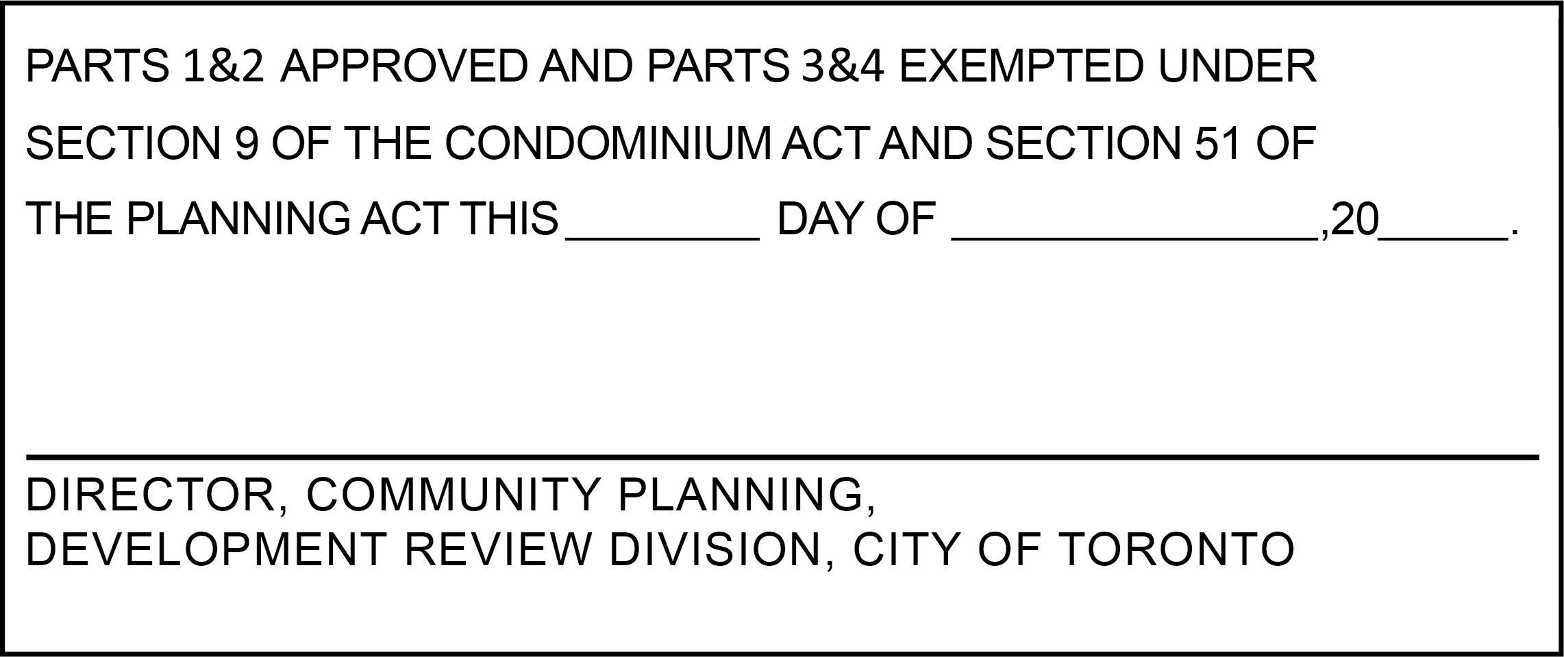
Include the Draft Approval Certificate on Sheet 1 of each set of Condominium plans submitted at time of application.
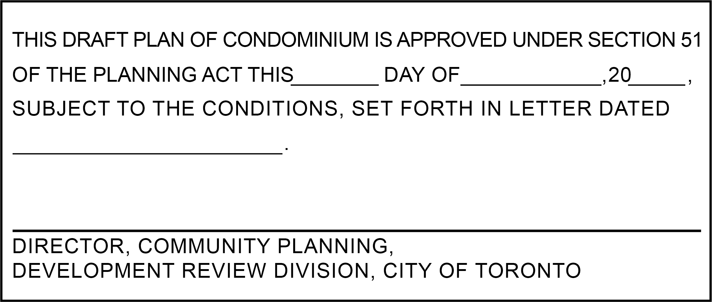
Section 51(17) of the Planning Act requires that plans show the following information, as appropriate:
Effective July 1, 2023
A draft zoning by-law amendment is a document that directs how lands, buildings or structures are used for specific purposes. The draft amendment describes the lands to which the amendment applies, lists recitals of the Ontario Planning Act, specifies additions or changes to the zoning map or overlay maps, lists site specific regulations, and specifies prevailing by-laws and sections.
If a property owner wants to develop a property in a way that is not permitted by the zoning by-law, they must apply for a Zoning By-law Amendment Application. A draft zoning by-law amendment is required as part of a Zoning By-law Amendment Application.
A draft zoning by-law amendment provides a preliminary framework for amendments to the zoning by-law that are required to permit the development, including use of certain sections of the Ontario Planning Act, like temporary use or holding symbol provisions.
The draft zoning by-law amendment must be submitted using one of the templates listed below. The selection of the template will be based on whether the lands are within City-wide Zoning By-law 569-2013 (By-law 569-2013 herein) or not, and if City Council or the Ontario Land Tribunal (OLT) is the approving authority. The Zoning By-law Amendment Writing Guide can help inform the selection of the appropriate template. The templates reference the “Commercial Residential (CR) Zone” as this is the most common zone for proposed developments.
Templates were revised as of March, 2026 (refer to the disclaimer below).
The Zoning By-law 569-2013 templates are provided for the purpose of consistent drafting of zoning by-law amendments and are intended to provide preliminary guidance at the time of preparation. Additional guidance on the use of the zoning by-law amendment templates is provided in the Zoning By-law Amendment Writing Guide. Every effort is made to ensure the accuracy of these templates, however, for legal and planning application purposes the templates are not a substitute for the verification of applicable Official Plan policies, including site and area specific policies, former general zoning by-law requirements, and all amendments to By-law 569-2013 that may apply to a development.
The Zoning By-law Amendment Writing Guide provides preliminary guidance in preparing a zoning by-law amendment and to assist the author in avoiding common errors. The Writing Guide provides guidance on how to correctly structure a by-law amendment, use correct terms, and create zoning diagrams. Review of the Writing Guide prior to submitting a zoning by-law amendment is optional but encouraged.
The EMF Management Plan is a technical document (or plan) that provides an analysis of the electromagnetic fields (EMF) on the site of a proposed development that is within or abuts a hydro corridor. The EMF management plan identifies no-to-low-cost EMF exposure reduction measures based on the analysis.
Depending on the complexity of the project the EMF Management Plan must be prepared by a qualified individual as outlined in the Guidance Manual.
An EMF management plan is required for the following application types:
The authority to request an EMF management plan is provided by Toronto City Council’s decision to adopt a policy of prudent avoidance to reduce childhood exposure to electromagnetic fields (EMF) in and adjacent to hydro corridors with transmission lines.
Toronto City Council Decision Document (Meeting 23 July 15, 16 and 17, 2008).
An EMF Management Plan, in accordance with the EMF Management Guidance Document, should include the following elements:
The Guidance Manual contains information on the required contents of an EMF Management Plan as well as procedures to prepare an EMF Management Plan.
Effective May 1, 2022
The Energy Modelling Guidelines outline the energy modelling and reporting requirements under the Toronto Green Standard (TGS). These guidelines provide instructions and information on supporting documentation that is required for submission. The guidelines allow for a clear understanding of the energy conservation measures to be applied to the new development, and the simulation process that is undertaken to achieve the energy performance claimed.
For Site Plan Applications with proposed buildings that follow Part 3 of the Ontario Building Code (OBC) and are greater than 2000 m2 Gross Floor Area.
Applicants should follow the Energy Modelling Guidelines and submit the required documentation prior to Site Plan Approval to demonstrate the minimum Tier 1 level of performance in accordance with the TGS Operational Emissions and Energy requirements.
Refer to the following guidelines based on the application submission date for required content:
| Version | Site Plan Application Submission Date |
|---|---|
| Energy Modelling Guidelines Version 4 | On or after May 1, 2022 |
| Energy Modelling Guidelines Version 3 | Between May 1, 2018, to April 30, 2022 |
| Energy Modelling Guidelines Version 2 | Between January 1, 2014, to April 30, 2018 |
Contact City’s Environment and Energy Division at EnergyReview@toronto.ca for questions or discuss your project in more detail.
Effective May 1, 2022
The Energy Strategy explores opportunities for new development to achieve net zero emissions in keeping with TransformTO and the Toronto Green Standard Council-approved targets. The Strategy identifies and evaluates opportunities to reduce energy demand and emissions, including embodied carbon, and to be resilient to climate change. It recommends technically and financially viable solutions for further analysis and implementation during Site Plan Control approvals. The findings and recommendations will inform subsequent development applications and later studies including building energy modelling and associated infrastructure.
The Energy Strategy applies to new development including residential, non-residential and/or mixed use and may apply to industrial development:
in association with the following application types:
The NZ Emissions Strategy contributes to the Council approved TransformTO Net Zero Strategy and GHG Emissions by 2040 target (IE26.16). Official Plan policies 3.4.1c), 3.4.19 and 3.4.20 support and encourage the reduction of: energy consumption and GHG emissions and carbon-based fuel sources in development and redevelopment, consistent with international, national and Toronto’s GHG reduction targets and commitments.
The Strategy evaluates:
This section presents minimum requirements for completion of the Strategy and is not exhaustive. The applicant is encouraged to discuss the required contents with Environment & Energy Division staff prior to submitting the report.
| Building Type
|
Total Energy Use Intensity (kWh/m²) | Thermal Energy Demand Intensity (kWh/m²) | Greenhouse Gas Intensity (kgCO2/m²) | ||||||
|---|---|---|---|---|---|---|---|---|---|
| Tier 1 | Tier 2 | Tier 3 | Tier 1 | Tier 2 | Tier 3 | Tier 1 | Tier 2 | Tier 3 | |
| Multi-unit Residential Buildings (≥ 4 Storeys) | 135 | 100 | 75 | 50 | 30 | 15 | 15 | 10 | 5 |
| Multi-unit Residential Buildings (< 4 Storeys) |
130 | 100 | 70 | 40 | 25 | 15 | 15 | 10 | 5 |
| Commercial Office Buildings | 130 | 100 | 65 | 30 | 22 | 15 | 15 | 8 | 4 |
| Commercial Retail Buildings | 120 | 90 | 70 | 40 | 25 | 15 | 10 | 5 | 3 |
| Mixed Use Buildings(90% residential, 5% retail, 5% commercial) | 134 | 100 | 74 | 49 | 29 | 15 | 15 | 10 | 5 |
| All Other Building Types | Tier 1: ≥25 per cent improvement above SB-10, 2017
Tier 2: ≥35 per cent improvement above SB-10, 2017 |
||||||||
For phased development, project the anticipated Site Plan Application dates for each phase, taking the minimum performance requirements at that time into account in the report. Please note that the Tier 1 minimum performance requirements have been revised such that the GHGI target of 10 kg/m2 will apply in 2025, and 5 kg/m2 will apply in 2028. (See City Council Decision on IE26.16 “TransformTO – Critical Steps for Net Zero by 2040”, specifically item 1. a.)
The applicant will work with an energy developer on a preliminary analysis of low carbon heating and cooling solutions and report back to the Environment & Energy Division in the initial or a subsequent resubmission. Applicants proposing a total gross floor area of 100,000 square metres or more are required to evaluate development of an on-site thermal network (district energy system). Please note that this work is to be performed by the energy developer and may be included in an appendix section of the report.
If low carbon heating and cooling solutions are deemed not technically or financially viable at present, the applicant will evaluate future-proof design options (i.e. low-carbon ready). Refer to the Design Guidelines for Low Carbon Thermal Energy-Ready Buildings ![]() for more information.
for more information.
The applicant will also engage Toronto Hydro to discuss electrical distribution system design options to support decarbonization and resilience.
For further information please contact:
New Development & Renewable Energy
Environment and Energy Division, City of Toronto
Metro Hall
55 John Street, 2nd floor
Toronto, ON M5V 3C6
EnergyReview@toronto.ca
A study where a proposed development is likely to have impacts on aspects of the environment not adequately assessed in the Natural Heritage Impact Study.
An Environmental Impact Study may be required for the following application types:
The requirement for, and scope of, the Environmental Impact Study should be discussed with the Community Planner in pre-application consultation (PAC) meetings.
The authority to require an Environmental Impact Study is provided by the Planning Act, the City of Toronto Act, 2006, the Official Plan, the Provincial Policy Statement, the Greenbelt Plan, and Council-adopted policies and programs.
Terms of Reference are being prepared for this study. In the interim, the requirements and details of this study should you need one can be addressed during your pre-application consultation meeting.
To illustrate the layout of structures, entrances, rooms, windows and servicing elements on each floor of the proposed building, including the ground floor and below-grade floors.
Dec 2017
A Geotechnical Study is an objective, science-based sub-surface investigation study, prepared by a qualified expert (Geotechnical Engineer/Consultant) that analyses soil and bedrock composition to determine its structural stability and its ability to accommodate development. The study will be used to guide land use planning, the design and construction of buildings, municipal roads and services as well as to determine feasibility for infiltration of groundwater, if it is part of the proposal.
The Community Planner will inform the applicant that a Geotechnical Study is required.
These studies or reviews may be required for the following types of applications:
Geotechnical Studies are required for the design and construction of municipal roads and all developments.
The detailed design of any infiltration facilities will be based on site specific percolation tests. The number of tests will be dependent on the size of the facility and the different types of soils conditions found within the proposed facility foot print zone of influence.
Note: In addition to a Geotechnical Study a Hydrological Review is also required.
The applicant is responsible for the preparation and cost of these studies.
To provide an assessment in the event that there may be significant challenges in the conceptual designs, land requirements, detailed design, and construction stages of a development and to supplement Stormwater Management Reports.
The following is a general outline of information to be included in the Studies/Reviews:
Identification of subsurface conditions including:
A Geotechnical Study shall be prepared by a qualified expert who is in good standing and who is a licensed Professional Geotechnical Engineer. The signed, stamped and completed Study report must be submitted to the City, and the engineer signing the study report shall take professional responsibility for its content and the accuracy of the information contained therein.
August 2018
Hydrological Review Summary Form
A Hydrological Review, within the City’s context, is a review of the subsurface hydrologic and geologic conditions in an area or location to determine the quality and quantity of groundwater that may be required to be discharged to the City sewage works as a result of a proposed development.
The Hydrological review may be required for the following types of applications:
The applicant is responsible for the preparation and timely submission of the Review.
The Hydrological Review aims to provide the City and the Developer information to complete a technical review for the proposed development site to address the issues pertaining to groundwater quality and quantity in accordance with the proposed options of disposal.
The applicant shall ensure that, at a minimum, the reference materials listed below are used in the preparation of the Hydrological Review:
The Review area shall encompass the land area covering the largest possible zone of influence that could result from the proposed groundwater taking.
The Hydrological Report shall include at a minimum, the following information:
A site-specific hydrological model with site-specific hydrological information describing:
A minimum of five groundwater wells shall be installed at locations that represent the entire proximity of the site. If that site is larger than 30m x 30m additional groundwater wells shall be installed and the qualified professional will use professional judgment to determine the number of additional wells required. It is required that the wells be installed with a minimum of 3.8 cm diameter and 2 meters below the lowest elevation in the proposed building structure(s). Additionally, one well is to be drilled to a minimum depth of 10 m below the lowest elevation in the proposed building structure(s), or to bedrock, whichever is shallower. For sites with physical restrictions or smaller and site-specific sites pre-consultation with City Staff may be required to decide on the number of wells required.
Static groundwater level measurements shall be monitored at all wells located within the property for a minimum of 3 months with measurements taken every 2 weeks for a minimum of 6 measurements. The intent is for the qualified professional to use professional judgment to estimate the seasonally high groundwater level. Water levels can be measured manually or using pressure transducers and data loggers, or similar instrumentation. All water levels shall be presented as geodetic elevations referenced to a City of Toronto, or Canadian Geologic Survey benchmark.
Pumping tests may require a PTTW from the MOECC and discharge approval from Toronto Water if extracted groundwater is proposed to be discharged into the City’s sewage works. At minimum, the following are to be considered:
Static groundwater level shall be monitored at all pumping and observation wells several times prior to and after the pumping test to measure the recovery.
Slug test can be done to estimate hydraulic conductivity in certain circumstances. Developments where no construction dewatering or long-term groundwater management is required, slug tests are acceptable for each well. If any other method other than pump test is used or should a shorter time period be proposed detailed explanation of the rationale for the change is to be provided and agreed by City staff.
The report needs to include a baseline water quality review. The water quality must be analyzed for all the parameters listed in Chapter 681-Sewers of the Toronto Municipal Code. Non-filtered sample(s) must be collected from the proposed groundwater source(s). Water quality data must be analyzed by a Canadian laboratory accredited and licensed by Standards Council of Canada and or Canadian Association for Laboratory Accreditation. A true copy of the analysis report, Certificate of Analysis and a chain of custody record for the sample must be included with report. The water quality data must be collected within nine (9) months prior to the date of submission.
If the property proposes a PWDS then the Review shall summarize the post-construction groundwater discharge to the City’s sewage works from the proposed development. The Review shall clearly identify the proposed construction methods (ex. open cut, caisson wall) for the sub-structure. If the proposed sub-structure construction method is not available during the Review preparation then the Review shall be prepared identifying groundwater infiltration quality, quantity and peak discharge flow rate for all of the proposed construction methods. The Review shall include the total subfloor drain area, and information regarding the estimated total volume per day from the subfloor drain, and the perimeter drains.
In order to evaluate the capacity of the City sewage works, the Review shall provide the following detailed information:
The impact(s) of groundwater taking and discharging should be determined based on the maximum possible area of influence-using actual field testing data. Investigation should be performed to determine any adverse impacts as suggested below:
If it has been determined that there will be a negative impact to the natural environment, City’s sewage works, or the land stability, as a result of groundwater taking and discharging, the Review shall identify the following:
In the event that a proposed mitigation plan is recommended, subsequently, a follow-up report is required confirming that the affected zone has been returned to its pre-development condition prior to the groundwater taking and discharging.
Hydrological Review shall be prepared by a qualified person who is in good standing and a licensed Professional Geoscientist or exempted Professional Engineer as set out in the Professional Geoscientists Act of Ontario. The signed, stamped and completed Review report must be submitted to the City, and the qualified person shall take professional responsibility for its content and the accuracy of the information contained therein.
The Hydrological Review Summary Form must be completed and submitted by the Qualified Professional who prepared the Hydrological Review. The completed summary form must be attached to the Hydrological Review.
Effective April 13, 2026
A Heritage Impact Assessment (HIA) is an objective and independent professional study that is undertaken at the earliest stage of development approval stages. The HIA is a necessary part of project planning that should inform a project’s design with the goal of conservation of cultural heritage resources.
The HIA will also demonstrate, in its analysis and conservation strategy, an understanding of all applicable provincial and municipal policies, applicable Heritage Conservation District (HCD) plans and recognized professional heritage conservation standards in Canada including, but not limited to, the Standards and Guidelines for Conservation of Historic Places in Canada. In keeping with the Standards and Guidelines, minimal intervention will be the guiding principle for all conservation work.
The HIA will apply the understanding of the cultural heritage values and attributes of existing and potential onsite heritage resources, adjacent heritage properties and within or adjacent to HCDs.
For properties that meet the criteria to trigger the completion of a Cultural Heritage Evaluation Report (CHER), as identified in Official Plan Policy 3.1.6.22the understanding of that property will be achieved through a CHER, prior to development of the HIA. The completion of a CHER first is an important step to ensure the HIA is properly informed by the properties cultural heritage value and attributes early in the design process. The City of Toronto has developed a Terms of Reference to assist with the purpose and content of a CHER.
It is strongly recommended that the results of the CHER be shared with the City for discussion at the earliest opportunity to inform decision-making and avoid unnecessary delays.
Where City Council has previously adopted a designation by-law under Part IV of the Ontario Heritage Act (the “OHA”), the HIA must be based on the Council approved statement of cultural heritage values and attributes as set out in the designation by-law. A HIA that does not use the adopted designation by-law as the basis to assess impact will be deemed incomplete. Properties designated prior to 2005 will be subject to review and, as necessary, a by-law amendment may be recommended to Council to align with O. Reg 9/06 for designation under Part IV of the OHA.
Where the property is located within an in-effect Heritage Conservation District, the HIA must demonstrate how the proposed development satisfies the following requirements:
Where there is the potential to affect known or potential archaeological resources an Archaeological Assessment will be undertaken as an additional study prepared by a licensed archaeologist and the recommendations and findings should be incorporated into the HIA in Section 11.
The added purpose of the HIA is also to inform decisions of City staff and City Council on permit applications under the OHA and to guide the creation of a Conservation Plan and any other conditions of approval on the heritage permit.
A HIA will be required for the following development application types, if the development site contains one or more properties that are listed and/or designated on the City of Toronto’s Heritage Register:
In addition, an HIA will be required as part of a complete application where through Official Plan Policy 3.1.6.22, a CHER has identified that a property has cultural heritage value and meets the criteria under O. Reg 9/06 for designation under Part IV of the OHA.
*For Site Plan Control applications that have been subject to a recent Official Plan Amendment/Zoning By-law Amendment application, a HIA will not be required. In this circumstance, from a heritage planning perspective, the primary focus of a Site Plan Control application will be to ensure compliance with the approval of a heritage permit application, including being substantially in accordance with the approved Conservation Plan and any other relevant heritage permit conditions in the decision under the OHA.
All other Site Plan Control applications that include heritage properties must include a HIA and applicants must also obtain all heritage permits as may be required.
An HIA may be required for the following application types:
In completing an HIA, it is recommended that the Heritage Professional pre-screen any building 40 years of age or older on the development site as a routine part of pre-application due diligence, in particular if demolition of such buildings will be proposed.
The HIA will demonstrate conservation of the cultural heritage value of each existing or potential heritage resource(s) on a property (including archaeological resources), heritage resources adjacent to the property, and heritage resources within, or adjacent to, a HCD. The HIA will apply the relevant heritage conservation policies and standards in the analysis of the impact of development on the property’s cultural heritage value and will develop mitigation measures to conserve that cultural heritage value.
The HIA will, using both written and graphic formats, provide a description of the proposed development or site alteration, a detailed review of the impact of the proposed work on the cultural heritage values and attributes of the existing, potential and adjacent heritage properties (cultural heritage values and attributes that have already been determined by the City or, when unavailable, identified within a CHER) from a conservation perspective. The HIA will also recommend alternative development options and mitigation measures to ensure the best possible conservation outcomes.
The authority to require a HIA is provided by the Planning Act, the OHA, the Provincial Planning Statement and the Official Plan, which seek the identification, protection, management and wise use of heritage resources.
The HIA must be impartial and objective, thorough, complete and sound in its methodology and application of OHA evaluation criteria, the City of Toronto Official Plan Heritage Policies and the Parks Canada Standards and Guidelines for the Conservation of Historic Places in Canada and be consistent with recognized professional standards and best practices in the field of heritage conservation in Canada and the Canadian Association of Heritage Professionals (CAHP) Code of Conduct.
The HIA must be prepared by qualified professional members in good standing with the CAHP who possess applied and demonstrated knowledge of accepted standards of heritage conservation, historical research, identification and evaluation of cultural heritage value or interest, analysis and mitigation of the development on a property, collection of properties, or landscape feature that have cultural heritage value.
The HIA may be subject to a peer review if determined appropriate by the Senior Manager, Heritage Planning.
The Heritage Impact Assessment must contain the following, and be signed and sealed by the heritage professional(s) responsible for its preparation:
A Heritage Professional is a person who has specialized knowledge in the conservation and stewardship of cultural heritage resources and is supported by formal training and/or work experience. The professional must be a registered Professional member of the Canadian Association of Heritage Professionals and in good standing. The background and qualifications of the professional(s) completing the HIA must be included in the report.
The Heritage Professional responsible for the HIA must provide written confirmation that the HIA conforms to accepted technical and ethical standards and is in accordance with the regulations and guidelines of their specialty heritage fields and jurisdictions of practice, and that the information included in the HIA and, where applicable the CHER, is accurate and reflects their professional opinion.
This Section includes a summary of:
The Executive Summary will also include a clear statement of opinion about the appropriateness of the work as proposed, with specific reference to all applicable policies and guidelines.
The following information must be included in this Section:
Maps and photographs must depict the site boundary within a 300 metre radius, or as appropriate, to demonstrate the existing area context and identify adjacent heritage resources. Maps will be to a metric scale (i.e. 1:100, 1:200, 1:500)
Where a property is subject to a notice of intention to designate under Section 29 of the OHA, and no designation by-law has yet to be enacted, the HIA must rely on the cultural heritage values and attributes of the property which have already been identified by Council under the OHA.
Where a property is subject to a designation by-law made after 2006 under Part IV of the OHA, the HIA must rely on the cultural heritage values and attributes of the property which have already been determined in the designation by-law under the OHA.
Where a property is located within a HCD designated and in-effect under Park V of the OHA, the HIA must rely on the cultural heritage values and attributes of the property within the District which have already been determined under the OHA. Where the HCD was adopted before 2005, the HIA should consider the relevant guidelines to assist with understanding of the cultural heritage value and attributes of the district.
Where a property is located within a HCD designated and in-effect under Park V of the OHA, the HIA must rely on the cultural heritage values and attributes of the property within the District which have already been determined under the OHA. Where the property is located within a HCD with an HCD Plan in-effect after 2005, the HIA must also rely on the stated objectives, heritage attributes, and policies of the HCD Plan. Guidelines within a post-2005 HCD Plan may be used to inform how the policies of the HCD Plan are met and how to achieve the objectives of the HCD Plan.
Where a CHER is required by Official Plan Policy 3.1.6.22CHER has identified that a property has cultural heritage value and meets the criteria under O. Reg 9/06 for designation under Part IV of the OHA, a summary of the cultural heritage value and criteria met under O. Reg 9/06, as extracted from the completed CHER. The full completed CHER in accordance with the CHER Terms of Reference may be appended to the HIA, but it is recommended that the CHER be filed as a separate report.
Where a CHER is not required by Official Plan Policy 3.1.6.22, but to ensure that the understanding of a property is conducted in a consistent manner with O. Reg 9/06 under the OHA, a CHER as part of a HIA may be required for:
A CHER prepared in accordance with the City’s Terms of Reference is recommended for the above to ensure adequate information and material provided to the City.
This Section will include a description of existing and potential cultural heritage resources within the development site, and shall include:
Historic Photographs
Historic photographs should be provided, where available. If historic photographs cannot be located, it must be confirmed that the noted sources below have been checked.
At minimum, the resources that must be consulted include:
Current Photographs/Images
Current photographs/images taken within three (3) months of the HIA submission date showing the existing condition, context, attributes and other features of existing and potential heritage resources on the property that are unobstructed by landscaping, vegetation, vehicles, etc. The context includes other buildings and existing landscaping (mature trees, fences, walls, driveways) on the subject property. Photographs will include the following:
Description of Surrounding Neighbourhood Keyed to a Context Map
Provide a detailed narrative of the surroundings of the site with particular attention to subject street frontages or block faces, subject property and opposite side of the street frontage(s). Reference to architectural styles, profiles and ages of buildings should be included. A description of the existing “sense of place” where discernible and key to a context map should be provided.
Using the definition of “adjacency” in the City’s Official Plan, this Section must provide a description of each heritage property/resource adjacent to the development site, including:
The Section must provide a condition assessment of the on-site heritage resources. The condition assessment should not rely solely on a visual inspection. Recommended methods for determining the condition of the resource(s) include a structural engineering analysis, a geotechnical study, non-destructive and destructive testing where underlying conditions might be obscured by architectural elements, signage or other physical barriers.
Destructive testing on protected heritage properties may be subject to approval. Please consult Heritage Planning to confirm testing requirements needing a preliminary review.
Where such studies, including but not limited to, structural, engineering or other similar technical studies are prepared and relied on, they must be provided along with the HIA, either separately or as an appendix, and be signed and sealed by the professional qualified to prepare such study. A summary of the study findings will be included in the HIA in the appropriate section.
Written description and high quality colour photographic documentation of each existing and potential heritage resources on the development site in its current condition and a detailed visual and written description of the physical condition of the resources including, but not limited to:
Where a property is located within an HCD that identifies contributing or rated buildings, a condition assessment is not required for unrated or non-contributing buildings unless otherwise required within the HCD Plan.
In this Section, the plans, drawings, specifications and a description of the proposed development and/or site alteration must include all new development on and alterations and interventions to each designated and/or listed and/or potential heritage property on the development site.
The drawings and specifications should also show any internal heritage attributes described in the designation by-law and show any proposed changes to them.
If no changes are being proposed to a specific building, structure or heritage attribute on the subject property, the Heritage Professional must provide a written confirmation of such and provide written confirmation of its proposed conservation, instead of including proposed plans, sections and elevations of that specific building, structure or heritage attribute.
Where changes are proposed to a heritage property, the following information must be provided:
Proposed plans, sections and elevations showing any attributes proposed to be demolished, removed or reconstructed in RED and new construction and alterations in BLUE. Setbacks from the property line, and where applicable, step backs from existing heritage buildings should be dimensioned and included on the drawings. Where a property is designated under the OHA, alterations to a heritage property and/or demolition of specific heritage attributes of a heritage property will require a heritage permit application under Part IV and/or Part V of the OHA.
Approval under the OHA is required for any property designated under Part IV or V where the demolition or removal of a building, structure and/or attribute is proposed.
60 days’ written notice of intention to demolish a building or structure on a listed property must be submitted to the Chief Planner, consistent with the Toronto Municipal Code, Chapter 103.
The Heritage Professional must:
(1) Confirm in writing if NO demolition or removal is proposed; or
(2) Where the demolition and/or removal of a building, structure and/or heritage attribute is proposed:
In this Section, the Heritage Professional must provide a clear and objective analysis of the impact of all alterations and interventions (direct and indirect) that affect the cultural heritage value and attributes as described in the designation by-law or CHER of each existing, potential and adjacent heritage property or HCD is required.
The HIA must include:
Mitigation
Mitigation measures and/or alternative options are important components of the HIA as they describe ways to avoid or reduce negative impacts on all cultural heritage resources. Mitigation might also be achieved through modifications to the overall design of the project, for example exploring alternative parking arrangements, the modification of supporting caisson walls and other shoring and bracing strategies that allows for greater retention of built fabric, exterior walls, interior attributes and in situ preservation of cultural heritage resources, including archaeological resources, etc.
Where significant interventions occur, describe and provide a rationale for the alternative development approaches and mitigation measures that were explored but not recommended in this HIA for all cultural heritage resources, including archaeological resources.
Engineering Considerations
In the case of partial in situ or façade-only retention, temporary removal or relocation of a building or structure of an on-site existing or potential heritage resource, or when a compromised structure is cited as the reason for the preferred approach, an engineering study must be undertaken, signed and sealed by a Professional Engineer that confirms the feasibility of the proposed strategy and/or limitations in the context of the development/site alteration. An engineering study may also be requested in other circumstances.
A vibration or other site/construction management related study may be requested to assess any potential impacts to on-site or adjacent heritage resources, prepared by a qualified professional.
Conservation strategies will consider the existing condition of cultural heritage resource(s) and the constructability of the proposal. It is expected the project team will have undertaken sufficient investigation to confirm the capacity of the heritage resource to withstand the proposed intervention.
The engineering and/or technical study should consider (at minimum) overall site alterations, construction access, buried utilities, right-of-way management and construction/conservation methodologies. Recommendations must be based on a detailed understanding of the current condition of the resource(s) being conserved as described in Section 8.
Non-invasive testing of existing heritage fabric and other forms of ground investigation are strongly recommended at the earliest stages of the project. Purely visual inspection will not be an acceptable basis for decision-making.
A statement from a professional engineer confirming feasibility of a strategy that involves façade retention, temporary removal or relocation must be provided. Conservation strategies with engineering considerations must include this statement or the HIA will be deemed incomplete.
The Heritage Professional must provide an itemized summary of the conservation strategy as detailed and supported by the previous relevant sections of the HIA.
Statement of Professional Opinion
Early Consultation with the City
Applicants are encouraged to discuss their project in advance with Heritage Planning staff to confirm application requirements. It is recommended this be achieved through the City’s Pre-Application Consultation.
It is expected that a CHER will be prepared for identified properties in the early stages of the design and development process, prior to determining what changes may be appropriate. A CHER is recommended to be submitted to the City as a separate document before incorporation into the HIA and the submission of a development application, so that the heritage values can be discussed and confirmed.
Where conditional approval has already been granted under the OHA, document submission requirements should be discussed with Heritage Planning staff.
Links
For further information please contact:
Heritage Planning
City Planning Division, City of Toronto
heritageplanning@toronto.ca
Effective March 5, 2026
A Housing Issues Report provides information and analysis on the impacts of proposed development on the City’s supply of affordable and mid-range rental housing and tenants.
Applicants are encouraged to use the Housing Issues Report and rental data table templates. For a copy of the templates, please email Community Policy.
A Housing Issues Report is required when development proposes to demolish, intensify, convert or sever existing rental housing sites, or develop sites greater than five hectares with new residential uses.
Development application types that involve one or more of the above proposals, requiring a Housing Issues Report include:
For details, see Official Plan, Housing section 3.2.1; Official Plan Application Requirements schedule 3; and Municipal Code Chapter 667.
If the proposal involves retaining existing rental dwellings units within a redeveloped site, also provide:
If the proposal includes demolition of existing rental or social housing dwelling units also provide:
For applications that will result in the demolition of residential units that are/were owner-occupied, staff may request affidavits be provided to help determine residential tenure status to help support the review of the application. Link to the affidavit template.
For a list of required information, please email Community Policy.
An affordable housing strategy will be submitted that addresses how the proposal will contribute to a full range of housing and how affordable housing will be provided.
Details on the proposed affordable housing strategy will include the following:
To provide information and details for the proposed hard and soft landscaping on site and on adjacent streets and boulevards, using the Site Plan drawing as a base. This includes materials, dimensions and construction details for hard and soft landscape elements, including all pavement and solid structures, existing trees to be preserved and new trees, shrubs and herbaceous materials to be planted. Soil volumes for each planting area meeting City of Toronto Green Standards will be indicated.
For roof(s) which are wholly or in part landscaped, including green roofs, provide Landscape and Planting Plans for each level of roof with landscape, including:
To provide detail about lighting on the site and accessible roof areas, including the location and type of lighting fixtures proposed on the exterior of the building and on the site. Vertical photometric overlays will show proposed lighting levels. This drawing will demonstrate compliance with appropriate City standards, including City of Toronto Accessibility Guidelines, Toronto Green Standard and Bird Friendly Guidelines.
Using the Site Plan or Landscape and Planting Plan as a base, include:
Effective March 15, 2023
A Methane Gas Study identifies and evaluates the possible presence of methane at a proposed development site within the vicinity of a closed municipal landfill. It also provides potential mitigation measures that may be required to be undertaken based on a site assessment to be carried out by the applicant. A Methane Gas Study is comprised of a subsurface field investigation and a resulting subsurface gas investigation report.
The Methane Gas Study, including a subsurface investigation, is required for any proposed development sites on or within 500 metres (or within a previously determined area of influence) of a known or suspected closed (former) municipal landfill in accordance with Official Plan Policy 3.4.23.
The intent of a Methane Gas Study is as a screening-level investigation. It may be required for the following planning application types:
Where a Methane Gas Study is required in accordance with the Official Plan, this should be discussed during the pre-application consultation or the application submission process.
The Methane Gas Study will assess and identify the potential adverse impacts, and identify and implement any measures required to remediate or mitigate the possible presence of methane. Depending on the results of the subsurface investigation, further actions may be required by the City.
Landfill gas is a natural byproduct of the decomposition of organic material in landfills. It contains about 50% methane (CH4) and 50% carbon dioxide (CO2), as well as trace amounts of other gases. Methane gas is an odourless gas that can be produced by decomposition of waste or organic materials. It can accumulate in enclosed spaces, and possibly near building footings and basements/underground structures. Methane does not pose a human health risk, but is flammable at the lower explosive limit (LEL) of 5% by volume.
The Ministry of the Environment, Conservation and Parks Guideline D-4-1 Assessing Methane Hazards from Landfill Sites provides guidance on methane gas assessments and protective facilities. Land Use on or Near Landfills and Dumps (formerly Ministry of Environment Policy 07-07) recommends site conditions to be assessed for landfill gas in the vicinity of a landfill or dump.
The City of Toronto’s Solid Waste Management Services Division (SWMS) manages closed historical landfills located across Toronto. Applicants must conduct the necessary investigation, as well as implement and monitor proper control measures when required, to address potential risk.
A qualified person (as defined in Ontario Regulation 153/04) (“Qualified Person”) is required to be retained by the applicant to conduct the necessary assessments for the Methane Gas Study, including the subsurface field investigation for the possible presence of methane gas at the property. The investigation must provide coverage across the entire property, and be carried out such that the possible presence of methane gas can be adequately assessed. The key threshold used for the assessment is 1% by volume (20% of LEL). A minimum of two rounds of gas testing is required.
The Qualified Person should have experience with landfill/methane issues and/or investigations and have the expertise required to undertake a scope of work having the following minimum requirements:
SWMS should be consulted on the above items if required.
The above requirements represent a minimum scope of work. The Qualified Person has discretion and is expected to design a program with necessary investigations and assessment on a site-specific basis that allows the Qualified Person to conclude that there is low risk of methane gas at the property. This could include additional testing locations, more rounds of testing over a longer period of time (to include frozen ground conditions), characterization of gas, etc.
Once the subsurface gas investigation is completed, a Methane Gas Study Report, that includes the results of the subsurface gas investigation, shall be provided to the City along with a certified letter that is signed and stamped by the Qualified Person, to state whether or not the investigation indicates that methane gas is detected at or above 1% volume in air, at any subsurface location on the property.
In the event that methane gas is present at the property above 1% volume, the Methane Gas Study Report shall identify any measures required to remediate or mitigate the possible presence of methane and the manner of implementation of such measures.
The City may require additional testing, modifications to the subsurface field investigation, and peer review of the Methane Gas Study Report. Peer review is generally not required for routine investigations but may be required by the City if elevated methane concentrations are detected at a property, at larger spatial area across the property, or for review of the conceptual or detailed design of engineered gas controls.
For further information please contact:
SWMS Development Review
Solid Waste Management Services Division, City of Toronto
swmdev@toronto.ca
The Ministry of the Environment, Conservation and Parks (MECP) Guidelines:
An objective, science-based study, prepared by a qualified expert, of a proposed development’s potential impact on the natural heritage system shown on Map 9 of the City of Toronto Official Plan (2006) and ways to mitigate negative impacts on and/or improve the natural heritage system.
The authority to request this study is provided by the Planning Act, the 2005 Provincial Policy Statement and the 2006 Toronto Official Plan.
The Provincial Policy Statement specifies that natural heritage features and areas shall be protected for the long term and that the diversity and connectivity of natural features and the long-term ecological function and biodiversity of natural heritage systems should be maintained, restored or where possible, improved.
The Toronto Official Plan environmental policies recognize the importance of protecting, restoring and enhancing the natural ecosystem which includes the natural heritage system. Policy 3.4.10 states that development is generally not permitted in the natural heritage system illustrated on Map 9. Where the underlying land use designation provides for development in or near the natural heritage system, development will recognize natural heritage values and potential impacts on the natural ecosystem as much as possible; and minimize adverse impacts and, when possible, restore and enhance the natural heritage system.
All proposed development in or near the natural heritage system will be evaluated to determine the potential for the development to adversely impact the natural heritage system (policy 3.4.12). If it is likely that the development will have negative impacts on the natural heritage system then a Natural Heritage Impact Study may be required to assess these impacts and identify measures to mitigate impacts and/or improve the natural heritage system.
A Natural Heritage Impact Study is required in the following circumstances:
Natural Heritage Impact Studies may be required for the following types of applications:
The Community Planner will inform the applicant if a Natural Heritage Impact Study is required. The applicant is responsible for the preparation and cost of the study.
The following information will be included in the study:
The natural heritage issues to be addressed will be scoped in consultation with City/agency staff, consultants and through review of site specific information.
Where applicable, the following aspects of the natural heritage system will be addressed:
Key natural heritage information will be shown on a map in relation to the proposed development including: the limit of the natural heritage features and functions; the location of top-of-bank; the drip line of significant vegetation; the location of any provincially or locally significant features such as wetlands, areas of natural and scientific interest (ANSI’s) and environmentally significant areas.
The City of Toronto has a natural heritage inventory database which includes information on natural heritage features and functions. The information can be made available to the applicant for the site and surrounding area. Information from Natural Heritage Impact Studies will be used to update the natural heritage inventory database.
Information on flora and fauna may need to be collected over a three season period (spring, summer and fall) in order to be complete.
In some areas, the location of top-of-bank has already been determined by the TRCA; in other areas its location must be determined/confirmed through site specific field investigation in consultation with TRCA and City staff and may require the landowner/proponent to prepare surveys or geotechnical studies.
Natural heritage features and functions of interest may be located on or near to the site. The term near may require interpretation and will depend on the nature of the development (e.g., scale, extent of site alteration) as well as the proximity and type of natural heritage.
The impacts of the proposed development, both during construction and after completion, on the natural heritage features and functions will be identified and assessed.
Specific impacts may include the number and location of trees or amount of natural or naturalized vegetation to be removed, grade changes, area of stream bed to be disturbed, nature of changes to surface and subsurface runoff, amount of habitat removal/fragmentation/encroachment. Temporary impacts during construction may include habitat disruption, sediment transport and diversion of water flows. Impacts associated with ongoing occupation of the development may include increased noise and lighting, dumping of organic waste.
The measures that will be taken to mitigate negative impacts, both during construction and after completion, on the natural heritage features and functions identified in section 2.0 and the effectiveness of these measures will be specified. Where possible, adverse impacts will be avoided rather than mitigated. Mitigation proposals will be specific enough to allow evaluation of the effectiveness of the measures.
Development will be set back from the following locations by at least 10 meters, or more if warranted by the severity of existing or potential natural hazards:
Minor additions or alterations to existing development, replacement structures and accessory structures are exempt from this requirement.
Reducing or eliminating impact is preferred over mitigation. In some cases the development will need to be modified to avoid negative impacts. Monitoring and further mitigation may be required or may be part of impact management.
The study will describe any measures that will be taken to improve natural heritage features and functions, including measures to compensate for lost features or functions and enhancements to the natural heritage system. As much as possible, improvements will be accommodated in or adjacent to existing natural heritage features on-site before off-site locations are considered. Plans for natural heritage improvement must be approved by the City.
Summarize the findings, identify residual impacts that cannot be avoided or fully mitigated. Recommend conditions for development approval including monitoring, if appropriate.
Applicants should discuss the purpose, scope and content of the Natural Heritage Impact Study with appropriate City and agency staff before commencing the study.
The Natural Heritage Impact Study should be prepared early in the planning process to ensure that the constraints and opportunities associated with natural heritage on or near the site are known and can inform the development. City and agency staff will provide input to the terms of reference and review the report.
The Natural Heritage Impact Study should be coordinated with other studies related to fulfilling the following requirements:
Where possible, one coherent assessment of impacts related to the natural heritage should be prepared rather than a series of separate studies.
The principles and criteria which will be used to evaluate the Natural Heritage Impact Study and its recommendations are those set out in the Planning Act, Provincial Policy Statement, City’s Official Plan, and other relevant documents such as the Wet Weather Flow Management Policy.
A technical report that provides a written description of the impact of noise generated by a proposed development on the surrounding environment, the impact of noise from the surrounding environment on the proposed development and the impact of noise from the proposed development on itself as well as mitigation measures to reduce any negative impacts.
The report:
This Noise Impact Study is to be prepared, on behalf of the applicant, by a Consultant that is either an accredited Acoustic expert or a qualified Professional Engineer.
Noise Impact (Feasibility and/or Detailed Assessment) Studies may be required to support the following applications for developments that are adjacent to or nearby Employment Areas and for uses, such as airports, transportation/rail infrastructure, corridors and yards, waste management facilities and industries are adjacent to sensitive land uses:
Noise impact Studies may also be a requirement of a site specific zoning by-law.
The requirement for a Noise Impact Study may be a condition of initial approval of the proposed development.
Official Plan Section 2.2.4 (Policy 6) requires that development adjacent to or nearby Employment Districts should be appropriately designed, buffered and/or separated from industries as necessary to mitigate adverse affects including those from noise to promote safety and security.
Official Plan Section 3.4 (Policy 21) refers to the possible requirement of a study in cases where uses such as airports, transportation/rail infrastructure, corridors and yards, waste management facilities and industries are adjacent to sensitive land uses such as residences, educational and health facilities to appropriately design, buffer, and/or separate the facilities and uses from each other to prevent adverse effects from noise:
To assist in identifying impacts and mitigative measures, the proponent may be required to prepare studies in accordance with guidelines established for this purpose. The proponent will be responsible for implementing any required mitigative measures.
In addition to sensitive land uses, the Official Plan in Section 4.6 (Policy 6(f)) deals with mitigation of the effects of noise among other things in order to create competitive, attractive, highly functional Employment Areas. In addition, Section 3.2.3 (Policy 3) requires that the effects of nearby development including noise be minimized as necessary to preserve the quality of parks and open spaces.
4.1 (policy 2 and 3 (b)), 4.6 (Policy 6(i) (iv) and 7 (b))
During pre-application consultation, City Planning staff will work with the applicant’s consultant to determine if such a report is requires and, if so, the specific requirements of the Study, based on the nature of the proposed application and the context of the study area.
The Study should include, but is not necessarily limited to:
Note: The City of Toronto may wish to hire an outside consultant, at the expense of the applicant, to peer review selected technical reports submitted in support of a development application where there is no in-house expertise available).
Effective June 1, 2022
A Pedestrian Level Wind Study (‘Wind Study’) is a technical report that provides a model and written description of the wind impact of a development. The Wind Study will inform and direct the development design to be wind responsive, and ensure that wind conditions in and around the development are appropriate at various times of the year. The City’s Pedestrian Level Wind Study Guide document provides additional requirements.
A Pedestrian Level Wind Study deals with the mechanical and safety effects of wind on people and how conducive it is to pedestrian use of outdoor areas in the city. The purpose of the Study is to reduce undesirable wind activity, allow proper air circulation and to create comfortable spaces that encourage outdoor pedestrian usage throughout the year. Thermal comfort is further addressed in Official Plan policies.
The City will require a Wind Study for a Zoning By-law Amendment if the triggers below are met.
The City may require a Wind Study for the following application types:
“Triggers” refer to properties or circumstances of a project, such as (but not limited to) the scale, massing, height, location, density of surroundings and proximity to important areas, are known to be contributing factors for noticeable wind impacts surrounding a proposal under review. The City’s Pedestrian Level Wind Study Guide document identifies categories of triggers, including: height related to geographical location, and additional (special) conditions such as context.
If the application meets the conditions specified under the list of triggers, then Wind Study/Studies would be required for the project.
Project height triggers are classified into three levels – Low, Moderate and High– and are related to the location of the project. A Wind Study will be required for developments over six storeys / 20 metres in height. Following the Height Trigger classification of the project, if one or more of the following apply to the project, the project will shift to the next higher Trigger Level.
A written report documenting the Wind Study and conclusions must be provided. The report must comply with the requirements and format provided in the Pedestrian Level Wind Study Guide document. Template A should be located at the front of the report.
The report should include the following:
If applicable/required, Peer Review.
Wind Study reports should present the following scenarios:
The study may include the following:
If the City is not satisfied with the level of experience demonstrated by the consultant or wishes to verify the results of a study, a peer review of the Wind Study may be required by the City. The cost of the peer review is to be borne by the applicant.
A Perspective Drawing is required for projects 4000 sq.m. or larger for the following application types:
Effective August 16, 2022
The Planning Rationale provides an overall planning framework for understanding the proposal from the applicant’s point of view. This document is intended to help the applicant organize and substantiate the application and to assist staff in the review of the proposal to expedite the City’s responses.
Depending on the complexity of the application, the information requirements can be addressed in a letter of several pages or a longer report. The material can be prepared by the owner, the agent, the applicant or a member of the consultant team, depending on the nature of the application.
A full Planning Rationale is required for the following applications:
A Covering Letter is required for the following applications:
The Planning Rationale is required to:
The Planning Rationale shall contain:
The Covering Letter for Plans of Condominium involving new condominiums, smaller Site Plan Control, Part Lot Control and Consent applications shall contain:
In addition, the Covering Letter for Plan of Condominium applications should provide a description and background on the type of application (i.e., leasehold, common elements, phased, vacant land, standard) and on any related planning approval process or on any unusual circumstances (i.e., strata plan). The letter should identify whether the application is the same as the approved Site Plan and if there have been any changes, what those changes are and why. If there was no previous planning process including Site Plan Control approval, the letter should explain the circumstances (i.e., conversion of rental).
In addition, the Covering Letter for Consent applications shall contain:
Should an application be submitted in a Mixed Use Area on an Avenue (as illustrated on Map 2 of the Official Plan) prior to the City undertaking or completing an Avenue Study for the surrounding area, the Planning Rationale should address the issues outlined in Policy 2.2.3 (3b) of the Official Plan, as well as the Council approved Avenues and Mid-Rise Buildings Study.
Should an application be submitted seeking to locate sensitive land uses such as residences and educational and health facilities adjacent to major facilities such as airports, highways, railway corridors and waste management facilities, the Planning Rationale should address the issues outlined in Policy 3.4.18 of the Official Plan.
Should an application be submitted seeking to implement the Official Plan permissions for large scale, stand alone retail stores or power centres on major streets bordering an Employment Area (as illustrated on Map 3 of the Official Plan), the Planning Rationale should address the issues outlined in Policy 4.6 (3a and 3b) of the Official Plan.
Should an application be submitted in Mixed Use Areas 1, Mixed Use Areas 2, Mixed Use Areas 3 and Regeneration Areas within the Downtown Plan area (as illustrated on Map 6A of the Official Plan) applicants will be required to submit a Complete Community Assessment as described in the Toronto Development Guide Glossary of Terms.
Effective March 23, 2026
To record the physical details and statistics of the site and development proposal for the application type, in terms of the existing, retained, proposed and total uses, areas, setbacks, buildings, units and other project components.
The required details and statistics of the development proposal include but are not limited to:
A completed Project Data Sheet will be required as part of a Complete Application for the following planning application types:
Submitting the Project Data Sheet in its original format is necessary to enable capture of the information that has been recorded and to assess development proposals and the completeness of development applications. Part of this information will also be utilized to address the City of Toronto’s compliance with Planning Act R.S.O. 1990 and O.Reg. 73/23 and O.Reg. 1/25: Municipal Planning Data Reporting.
These Terms of Reference are Applicable as of October 1, 2018.
The Public Consultation Strategy Report is a complete application submission requirement brought about by amendments to the Planning Act on July 1st, 2016. The requirement is referenced in Planning Act Regulations 178/16, 179/16 and 180/16. This statutory requirement is intended to “get the applicant thinking” in a pro-active manner about:
The public consultation strategy proposed should be reflective of the location, complexity, scale and nature of the proposal and may be prepared by the owner, the agent, the applicant, or a member of the consulting team.
The Public Consultation Strategy Report needs to be deemed complete by the municipality within 30 days of receipt of the application. Even after the Report is deemed complete however, applicants are encouraged to view the Report as a “living document” that may need to be updated and revised in collaboration with planning staff, at a later time in the Development Application review process, in order to stay relevant during the entire process.
All public consultation outcomes, whether initiated by the applicant or the City, will be documented and become part of the municipal (Council) record that informed Council in making the decision to approve or refuse the application.
The Public Consultation Strategy Report is a complete application requirement for the following application types:
Note: Before submitting a Development Application for review to the City, applicants are encouraged to meet with City staff at a pre-application consultation to discuss the proposal to get a clearer understanding of what is required, including consulting with staff with regard to the Public Consultation Strategy Report complete application requirement.
City Planning staff will hold at least one community meeting in the area affected by the application, in addition to the minimum statutory meeting requirements of the Planning Act, for proposed Official Plan and/or Zoning By-law amendments prior to approval (as required by Section 5.5.1 of the Toronto’s Official Plan). The City will continue with its policy of asking the applicant to pay for the distribution of notices beyond 120 meters, when requested by Council to do so, in association with this community meeting.
Unless otherwise agreed to, the cost of any other public consultation referenced in the Public Consultation Strategy Report will be at the expense of the applicant.
The Public Consultation Strategy Report will include the following:
What the applicant wishes to accomplish in engaging and consulting with the public with regard to the proposal.
Key messages the applicant would like conveyed to the public during the consultation process with regard to the proposal.
What the applicant hopes to achieve or accomplish by the end of the consultation period with regard to the proposal.
The applicant will identify the proposal’s geographic area of impact and explain why this area of impact was chosen. The geographic area of impact can be both local and citywide, depending on the proposal. Direct and indirect impacts will be considered in determining the area(s) of impact.
The applicant will provide a demographic profile of the geographic area of impact and identify the target audience(s) potentially impacted by the proposal to be consulted throughout the consultation period, including groups that may be more difficult to engage and/or who may not be familiar with the City’s public consultation processes, such as youth, segments of the senior’s population or recent immigrant groups to the City.
The applicant will identify a list of matters to be brought forward for discussion and consultation, propose a communication strategy for updating the list and reporting out on matters requiring follow-up and/or further resolution.
The applicant will prepare Communication and Consultation Strategies for contacting and engaging the audience(s) including how the public consultation(s) will be advertised.
The applicant may choose to communicate through in-house publications; on-line information (website, emails, social networks, open data, digital engagement); open houses; stakeholder working groups (including residents, local business associations, special interest associations); workshops; focus group interviews; store fronts; surveys; questionnaires; on-line comments such as blogs, forums etc.
The Communications Strategy will outline how the public will be informed with regard to major milestones (such as major revisions) related to the proposal.
The applicant will provide an evaluation of the public consultation held and make this evaluation available to the public consultation process participants at the conclusion of the public consultation period, prior to the Development Application proceeding to Council for approval or refusal.
For the purposes of this Terms of Reference, a demographic profile means:
For the purposes of this Terms of Reference, the “public” means:
The public can include:
For the purposes of this Terms of Reference, geographic impact means:
The applicant may apply information gathered from other complete application submission studies (such as the Community Services/Facilities Study / the Housing Issues Study / the Traffic Operations Study, the Building Mass Study, the Sun/Shadow Study), when applicable, in preparing the Public Consultation Strategy Report for the application.
Statistics Canada Data Sources:
City of Toronto Data Sources:
Data, Research, Maps, Neighbourhood Profiles
Planning & Development - Research Reports
TDSB Data:
Toronto District School Board Census Publications
The applicant is also encouraged to provide City Planning staff with meeting/activity notes stemming from meetings/activities held with the public prior to submission to the City of the complete application submission.
Public consultation meetings/activities will be aligned with the requirements of the Accessibility for Ontarians with Disabilities Act (AODA) and the City’s commitment to creating an accessible city
To obtain sufficient utility data to ensure the coordination of built form, and public realm with tree planting areas. Provide the existing/proposed location of utilities in and under the boulevard, as well as proposed lateral connections and infrastructure for the development within the right-of-way and on the development site. Utility data is to be provided as per the American Society of Civil Engineers (ASCE) Standard 38, to Quality Level B (QL-B). Where tree planting locations are proposed, provide utility data to Quality Level A (QL-A). QL-A provides precise horizontal and vertical utility information, typically obtained by exposure (i.e. “daylighting”) using minimally intrusive excavation equipment. Quality level of the subsurface utility data should be clearly noted adjacent to the professional stamp of the consulting engineer, on all plans and documents as certification of the quality level. The Public Utilities Plan should be submitted as a separate plan, and also as an underlay (in grey) on the Landscape and Planting Plan and the Soil Volume Plan (SVP) and any soil cell drawings, if applicable. The Public Utilities Plan may need to be resubmitted as part of the development application review and circulation process if changes to utilities are proposed and/or recommended.
Effective September 6, 2024
The Rail Safety and Risk Mitigation Report for derailments (RSRM report) is required for all applications that propose development of a new or intensified land use in proximity to heavy rail facilities across Toronto.
The RSRM report is intended to inform and assist Council in its decision making regarding the proposed development of the subject lands. As such, it shall be prepared, signed, and stamped by a qualified engineer and offer conclusive evidence that the proposed approach to derailment risk management and safety measures provide an equivalent level of safety as the City’s preferred approach.
The City’s preferred derailment risk mitigation approach is in keeping with the best practice approach as set out in the Federation of Canadian Municipalities and Railway Association of Canada’s (FCM/RAC) Guidelines for New Development in Proximity to Railway Operations (the Guidelines). This best practice is set at a minimum 30 metre setback from the property line of the nearest rail facility to the nearest proposed land use, combined with a 2.5 metre high earthen berm.
RSRM reports will be required in order for the following development applications to be deemed complete where they propose to introduce new or intensified land uses within 30 metres of a rail facility:
RSRM reports will also be requested in relation to other types of applications where safety is a concern, including Minor Variance applications considered by the Committee of Adjustment.
Once an RSRM report has been submitted, peer reviewed and accepted by the City and provided to the applicable rail operator, a new report may not be required for subsequent applications so long as the orientation of uses on site in relation to rail facilities is not changed. If there is a change to the orientation of land uses, a change to setback distances or other site conditions which would alter the effectiveness of the risk mitigation measures, a new RSRM report may be required.
Official Plan Section 3.6, Rail Facilities, Mitigating Derailment and Public Safety requires that the design and installation of rail safety and risk mitigation measures be undertaken for development in proximity to rail facilities, as deemed necessary, in keeping with the FCM/RAC Guidelines. Where the Guidelines are revised or replaced, these Terms of Reference will be updated as required.
The required RSRM report provides a review of physical conditions of the subject site, the location of proposed land uses in relation to nearby rail facilities, rail operations and potential impacts on proposed development should derailment occur. The RSRM report is focused on the physical risks of derailment, and does not cover all of the conditions which may require review to address all of the issues and impacts of developing near rail facilities.
Additional studies which may be required to completely capture the impacts of development in proximity to rail facilities include, but are not limited to, Noise Impact Studies, Vibration Studies and Stormwater Management Reports.
The objective of the peer review process is to provide Toronto City Council with an independent, expert, third party assessment of the potential land use compatibility issues as well as the proposed mitigation measures. The purpose is to assist Council in making fully informed land use planning decisions.
The peer review will evaluate:
The peer reviewer will provide to the City, at the cost of the land use proponent, a summary of their independent evaluation of the RSRM report.
A peer review of a RSRM report will evaluate the proposed safety and risk mitigation measures in keeping with the Guidelines, and be based on the following technical information to be provided in the RSRM report:
| Rail Facility Type | Noise Study Influence Area | Vibration Study Influence Area |
|---|---|---|
| Rail Yard | 1,000 metres | 75 metres |
| Principal Main Line | 300 metres | 75 metres |
| Secondary Main Line | 250 metres | 75 metres |
| Principal Branch Line | 150 metres | 75 metres |
| Secondary Branch Line | 75 metres | 75 metres |
| Spur Line | 75 metres |
Note: The Rail Safety and Risk Mitigation Report will be subject to a third-party peer review retained on behalf of the City and at the applicant’s expense.
To show the plan of the roof, including the location of rooftop mechanical systems, accessible outdoor areas, hard and soft landscape elements, and other details as appropriate.
The Green Roof By-law sets out a graduated green roof requirement for new development or additions that are greater than 2,000 m² in gross floor area. Refer to the City of Toronto Green Roof By-law webpage for more details.
Effective June 2, 2025
To evaluate the effects of a proposed change to the Official Plan that may impact the City’s municipal servicing infrastructure (including sanitary, storm and water) and watercourses, or the effects of development on the City’s municipal servicing infrastructure and watercourses.
A Servicing Report must conduct capacity analyses to determine if the existing municipal servicing infrastructure has the capacity to accept demand generated by a proposed development or, where applicable, the proposed change to the Official Plan. If the analysis identifies that the existing municipal infrastructure does not have available capacity, the Servicing Report must also identify any improvements to existing municipal infrastructure, or new municipal infrastructure, to support the proposed change to the Official Plan or to support the proposed development. The Servicing Report must be prepared by a Licenced Professional Engineer specialized in municipal engineering.
Where a Stormwater Management Report is required, the Servicing Report must also include a summary of the stormwater management plan documented in detail in the Stormwater Management Report (refer to the Stormwater Management Report - Terms of Reference).
A Servicing Report is required for the following application types:
**For Site Plan Control applications, the Servicing Report will require a capacity analysis if there is a change to the existing sanitary drainage pattern, a zoning requirement to be satisfied, changes to the combined sewer system, or in limited cases groundwater foundation drainage discharge proposed to the sanitary system or both.
The authority to require this work is provided by the Planning Act, the City of Toronto Act, 2006. the Official Plan, the Provincial Planning Statement, Council-adopted policies, guidelines and standards (e.g., Wet Weather Flow Management Policy, levels of protection under Basement Flooding Protection Program, etc.), the City’s Sewers By-law (Toronto Municipal Code, Chapter 681) and Water Supply By-law (Toronto Municipal Code Chapter 851). The Servicing Report must be prepared in conjunction with the Conceptual Servicing Plan and, where applicable, the Stormwater Management Report. For Site Plan Control, the Servicing Report must be prepared in conjunction with the Servicing Plan and the Stormwater Management Report.
Analysis and recommendations presented in the Servicing Report must meet all requirements established in the City of Toronto’s municipal engineering design policies, guidelines and standards, including but not limited to, the most recent edition of:
The Servicing Report must also demonstrate compliance with all applicable Provincial legislation (e.g., Ministry of Environment, Conservation and Parks), applicable regulations, and applicable provincial guidelines/procedures, including but not limited to:
The Servicing Report must contain the following, and be signed and sealed by the Licensed Professional Engineer(s) responsible for its preparation:
For further information please contact:
Development Engineering, Central Review Unit
Engineering & Construction Services Division, City of Toronto
devengcru@toronto.ca
The following potable water, storm and sanitary sewer servicing requirements apply to all new development applications in the City of Toronto, excluding residential developments of less than 5 dwelling units. These requirements apply in addition to and separate from any other municipal by-law or legislative requirements, including but not limited to those under the Toronto Municipal Code Chapters 681 and 851 or the Ontario Building Code.
Every tower shall have its own independent service connection to the municipal potable water and sewer services, including all associated stormwater management facilities. For clarification, this applies regardless of any shared podium structures, common underground parking structures, or anticipated ownership structures (including all forms of rental or condominium ownership). Any podium that provides a base for more than one tower above shall also have its own independent service connection to the municipal potable water, storm and sanitary sewer services.
Every anticipated standard or common-elements condominium corporation shall have an independent servicing connection to the municipal potable water and sewer services, including all associated stormwater management facilities.
Unless otherwise notified in writing at the time of application, staff will review all townhouse applications on the assumption that they will form part of one standard or one common-elements Condominium Corporation. If any party, including but not limited to the applicant and all subsequent owners of the development, applies for more than one condominium corporation encompassing any or all of the development, different service connections, including revised plans and studies, may be required by the City at the sole cost to that applicant.
Every parcel of land that will be separately conveyable requires its own servicing connection to the municipal potable water and sewer services, including all associated stormwater management facilities. In this situation, each condominium corporation will be considered its own parcel of land.
Unless otherwise notified in writing at the time of application, staff will review all commercial and industrial applications on the assumption that they will form part of one parcel of land. If any party, including but not limited to the applicant and all subsequent owners of the development, applies to sever or condominiumize any part of the development, different service connections, including revised plans and studies, may be required by the City at the sole cost to that applicant.
Every building shall have its own independent servicing connection to the municipal water and sewer services, including all associated stormwater management facilities, regardless of any shared podium structures, common underground parking structures, or anticipated ownership structure (including all forms of condominium ownership).
Effective January 24, 2023
Graphics and/or Drawings will be used to communicate and share information on submitted applications and can be inserted “as is” directly into Staff Reports and public-facing materials without further manipulation. These Graphics and/or Drawings are required to provide a clear and simplified visualization of the proposal and do not replace other detailed drawings submitted for review.
The required Graphics and/or Drawings include: Site Plan(s), Elevation(s) and two views of a 3D Model(s) of the Proposal in context. Other drawings may be requested, as appropriate.
To show the building’s exterior massing, design features, scale and materials in relationship to the site and context. The Site and Building elevations should include a complete set of dimensioned elevations for the proposal that provide the necessary information to site the building in its context, with the massing and outline of the building(s) and grading of adjacent developments shown as context.
Additional detail of the elevations and process for review is required as part of Site Plan Control. This additional detail includes 1:50 scale coloured elevation (see the details in the Development Guide) and physical sample boards may be requested.
To show the relationship between interior and exterior spaces, as well as the relationship between these spaces and the site, including grading and landscape features. Sections should also demonstrate the relationship between the proposed building(s) and the context of adjacent streets, boulevards and properties.
Must be drawn to a standard metric scale, legible at 1:100 or 1:200 scale
For sites with simple building(s) and relatively flat grading, two section drawings, in opposite directions through the building and site, will likely be adequate. For larger sites and/or sites with complex grading, additional Section drawings to demonstrate the context may be required. Section drawings should include:
Effective January 2, 2025
To show detailed existing and proposed grading information for the site and building, and their relationship to adjacent and surrounding streets, boulevards and properties. The Site Grading Plan must be prepared by a Licenced Professional Engineer specialized in municipal engineering.
A Site Grading Plan is required for the following application types:
The authority to require this work is provided by the Planning Act, the City of Toronto Act, the Official Plan, the Provincial Planning Statement, and to support Council-adopted policies and programs. The Site Grading Plan should be prepared alongside the Site Servicing Plan to support the Servicing Report, and where required, the Stormwater Management Report. The Site Grading Plan is also a statutory requirement for Site Plan Control under subsection 114(5) and (11)(a) of the City of Toronto Act, 2006 as part of a complete application.
For further information please contact:
Development Engineering, Central Review Unit
Engineering & Construction Services Division, City of Toronto
devengcru@toronto.ca
To show the proposed ground floor and key elements of the site, including pedestrian, bicycle and vehicular circulation, hard and soft landscaping, and grading, on site and in context with adjacent streets, boulevards and properties.
The Site Plan includes a significant amount of information and detail and will be reviewed together with other, more detailed drawings. The Site Plan is to be used as the base for other drawing submissions, including the Site Grading Plan, Landscape and Planting Plan and Lighting Plan, with detail removed as appropriate. For small and simple sites, the information and detail of these other drawings can be integrated with the Site Plan Drawing (to be discussed during pre-application).
The Streetscape Plan and Sections will use the Public Utilities Plan as a base and provide a consolidated set of drawings that allow for an informed review of the streetscape design, including utilities, hard and soft landscaping and building elements.
The streetscape will be shown in both plan and in section(s), demonstrating the relationship between existing/proposed utilities (with the Public Utilities plan as an underlay) and street(s) and setback(s). Consult staff and appropriate guideline documents including the Streetscape Manual, Green Streets Technical Guidelines and other City of Toronto standards and guidelines for appropriate guidance. These drawings will include:
Effective January 2, 2025
To show how the site will be provided with municipal services and that those services comply with the City’s policies, policies, guidelines and standards. The Site Servicing Plan includes information to allow for technical review of the proposed site servicing.
A Site Servicing Plan is required for the following application types:
The authority to require this work is provided by the Planning Act, the City of Toronto Act, the Official Plan, the Provincial Planning Statement, Council-adopted policies and programs (e.g., Wet Weather Flow Management Policy, levels of protection under Basement Flooding Protection Program, etc.), the City’s Sewers By-law (Toronto Municipal Code, Chapter 681) and Water Supply By-law (Toronto Municipal Code Chapter 851). The Servicing Plan is a component of the Servicing and Stormwater Management Report(s) set out in the regulations under the Planning Act and Schedule 3 of the City’s Official Plan and is also a statutory requirement for Site Plan Control under subsection 114(5) and (11)(a) of the City of Toronto Act, 2006 as part of a complete application.
Servicing design presented on the Site Servicing Plan must meet all requirements established in the City of Toronto’s municipal engineering design principles and guidelines, including but not limited to, the most recent edition of:
And ensure compliance with all applicable Provincial (e.g., Ministry of Environment, Conservation and Parks) acts, and regulations in effect, including but not be limited to:
Existing public and private infrastructure abutting or within the site including:
Proposed public and private infrastructure abutting or within the site including:
For further information please contact:
Development Engineering, Central Review Unit
Engineering & Construction Services Division, City of Toronto
devengcru@toronto.ca
The following potable water, storm and sanitary sewer servicing requirements apply to all new development applications in the City of Toronto, excluding residential developments of less than 5 dwelling units. These requirements apply in addition to and separate from any other municipal by-law or legislative requirements, including but not limited to those under the Toronto Municipal Code Chapters 681 and 851 or the Ontario Building Code.
Every point tower shall have its own independent service connection to the municipal potable water and sewer services, including all associated stormwater management facilities. For clarification, this applies regardless of any shared podium structures, common underground parking structures, or anticipated ownership structures (including all forms of condominium ownership). Any podium that provides a base for more than one point tower shall also have its own independent service connection to the municipal potable water, storm and sanitary sewer services.
Every anticipated standard or common-elements condominium corporation shall have an independent servicing connection to the municipal potable water and sewer services, including all associated stormwater management facilities.
Unless otherwise notified in writing at the time of application, staff will review all townhouse applications on the assumption that they will form part of one standard or one common-elements Condominium Corporation. If any party, including but not limited to the applicant and all subsequent owners of the development, applies for more than one condominium corporation encompassing any or all of the development, different service connections, including revised plans and studies, may be required by the City at the sole cost to the condominium applicant.
Every parcel of land that will be separately conveyable requires its own servicing connection to the municipal potable water and sewer services, including all associated stormwater management facilities. In this situation, each condominium corporation will be considered one parcel of land.
Unless otherwise notified in writing at the time of application, staff will review all commercial and industrial applications on the assumption that they will form part of one parcel of land. If any party, including but not limited to the applicant and all subsequent owners of the development, applies to sever or condominiumize any part of the development, different service connections, including revised plans and studies, may be required by the City at the sole cost to that applicant.
Every building shall have its own independent servicing connection to the municipal water and sewer services, including all associated stormwater management facilities, regardless of any shared podium structures, common underground parking structures, or anticipated ownership structure (including all forms of condominium ownership).
Effective December 1, 2024
The Soil Volume Plan, including the landscape plan, public utility plan overlay, section drawings and statistics template, provides information on soil volumes proposed on the site and within the adjacent street(s) and boulevard, including location and dimensions of soil volume area(s), physical encumbrances affecting proposed soil volume including existing/proposed utilities and below grade structures, and layout of the proposed suspended pavement system (e.g. soil cells, structural footings, or similar).
To show information and detail that verifies sufficient soil volumes to support tree planting and healthy tree outcomes early in the planning process in conformity with the Official Plan and as part of the Toronto Green Standard.
The Soil Volume Plan helps address and balance the broader City objectives of achieving an enhanced public realm, climate resilience and community health, and protecting and maintaining infrastructure. By providing sufficient and accurate information and materials early in the planning process, it provides certainty with respect to potential conflicts with proposed tree planting and how they can be addressed.
A Soil Volume Plan will be required as part of a Complete Application for Zoning By-law Amendment, Draft Plan of Subdivision, Consent to Sever and Site Plan Control Approval Applications.
The Soil Volume Plan may need to be resubmitted with updated utility information as part of the development application review and circulation process if changes to tree planting locations or utilities are proposed and/or recommended.
Where a Site Plan Control Application implements an approved Zoning By-law Amendment Application, and a Soil Volume Plan meeting the City’s requirements has been previously submitted in connection with the zoning application, only a Site Plan drawing (replacing the Concept Site and Landscape Plan) is required.
The Soil Volume Plan is comprised of information to show the soil volume proposed including the trees to be planted, the location and dimensions of soil volume areas, physical encumbrances affecting proposed soil volume and the layout of the proposed system. Necessary components include:
Effective January 2, 2025
To identify, evaluate, and mitigate the impacts of the change in stormwater runoff on existing infrastructure and the environment due to a proposed development.
A Stormwater Management Report must determine improvements to municipal servicing infrastructure required to support the proposed of development, where applicable. As part of this report, it must also evaluate and determine mitigation measures to minimize negative impacts on stormwater management facilities, identify opportunities for improvements of stormwater management facilities and features onsite and nearby, and to ensure compliance with the City of Toronto’s Wet Weather Flow Management Policy (WWFMP) and other applicable guidelines, standards, and policies from the City of Toronto and other regulatory bodies. The Stormwater Management Report must be prepared by a Licensed Professional Engineer specialized in in municipal engineering/stormwater management. The Stormwater Management Report must include all appropriate reports, plans, computer modeling results and design calculations relating to how stormwater run-off is proposed to be managed.
The Servicing Report must also include a summary of the stormwater management plan documented in detail in the Stormwater Management Report (refer to the Servicing Report – Terms of Reference).
A Stormwater Management Report is required for the following application types:
*Note: Additional details/sections may apply for these application types. Specific sections are identified when additional details are required for Plan of Subdivision or Site Plan Control applications.
The authority to require this work is provided by the Planning Act, the City of Toronto Act, 2006. the Official Plan, the Provincial Planning Statement, Council-adopted policies, guidelines and standards (e.g., Wet Weather Flow Management Policy, etc.), the City’s Sewers By-law (Toronto Municipal Code, Chapter 681). The Stormwater Management Report must be prepared in conjunction with the Conceptual Servicing Plan or Site Servicing Plan and the Servicing Report.
Analysis and recommendations presented in the Stormwater Management Report must meet all requirements established in the City of Toronto’s municipal engineering design policies, guidelines and standards, including but not limited to, the most recent edition of:
The Stormwater Management Report must also demonstrate compliance with all applicable Provincial legislation (e.g., Ministry of Environment, Conservation and Parks), applicable regulations, and applicable provincial guidelines/procedures, including but not be limited to:
The Stormwater Management Report must contain the following, and be signed and sealed by the Licensed Professional Engineer(s) responsible for its preparation:
The applicant is encouraged to discuss the scope and the proposed stormwater management concepts and design assumptions with Engineering and Construction Services prior to preparing the Stormwater Management Report as part of the submission of a prescribed application.
For further information please contact: Development Engineering, Central Review Unit
Engineering & Construction Services Division, City of Toronto devengcru@toronto.ca
Note: At the time of Draft plan approval, a District Landscape Plan and Architectural Control Guidelines may be secured.
Effective June 1, 2022
To provide a visual model and written description of the impact of shadows cast by a proposed development on surrounding streets, parks and open space (including natural areas), privately owned publicly-accessible spaces and other properties. The Sun/Shadow Study is done to evaluate the impact of shadows at various times of day, throughout the year.
A Sun/Shadow Study may be required for the following applications for developments over six storeys / 20 metres in height:
A Sun/Shadow Study may also be requested for developments that are less than 20 metres, in particular for Rezoning Applications where additional height is applied for near shadow sensitive areas (such as parks and open spaces, schoolyards, cemeteries, etc.). The requirement for, and scope of this work, should be discussed with the Planner and Urban Designer during Pre-Application Consultation meetings.
The Sun/Shadow Study may need to be resubmitted as part of the Development Review Process if changes to the building siting, massing and design are proposed and/or recommended.
Sun/shadow testing of alternative building massing may be required during the application review process to assist in making decisions about how to best achieve Council’s goals regarding sun/shadow impacts.
A typical model will include all streets, blocks, parks and open spaces, as well as buildings to a distance adequate to show the shadow impacts during requested times.
The model will be presented in two parts, the first showing the existing conditions and the second showing the proposed development in its context. The proposed development context should include other approved but not yet constructed buildings within the model area. These should be graphically distinguished from the proposal and the existing built context.
Shadow diagrams should be provided in colour to a standard metric scale and include a bar scale on each sheet labelled in 1, 2, 5, 10, 20, 100 and 200 metre increments.
“As-of-right” or other site-specific applicable shadow conditions should be indicated clearly by a contrasting colour single-line overlay with explanatory notation provided in a printed legend, using the City’s Shadow Study Drawings Standards - Colour Analysis.
A Sun/Shadow Study should be done for March 21 and September 21 at hourly intervals between 9:18 am and 6:18 pm. All times are based in the Eastern Time Zone and must take into account Daylight Saving Time.
Development that proposes additional shadow impacts on parks and open space (including natural areas), will require supplementary sun/shadow tests at hourly increments for June 21st and December 21st to provide additional information on the impacts of shadows. Additional times may also be requested to respond to specific site contexts.
The Sun/Shadow Study will include:
Topographic Survey and Boundary Plan of Survey can be merged on to one plan or shown on separate plans. It must be recent and accurately reflecting the existing property.
Effective May 1, 2022 – New Toronto Green Standard Version 4
On June 2, 2026, Bill 98, Building Homes and Improving Transportation Infrastructure Act, 2026 received Royal Assent impacting the implementation of the Toronto Green Standard. Updates to the website and application documentation are in progress. In the interim, contact the Community Planner assigned to your file for any questions and guidance for new or under review Site Plan Control applications. For general inquiries about the Toronto Green Standard contact sustainablecity@toronto.ca.
The Toronto Green Standard (TGS) is Toronto’s sustainable design and performance requirements for new development. It provides an integrated set of performance measures, targets, and principles, to achieve more sustainable and resilient new development. The TGS addresses environmental issues including air and water quality, greenhouse gas emissions, energy efficiency, solid waste, and enhancement of the natural environment.
The Toronto Green Standard was first introduced as a voluntary standard for new development in 2006. The TGS became a mandatory requirement of planning approvals with Version 1 and 2, introduced in 2010 and 2014 respectively. Version 1 and 2 were structured with two-tiered performance levels, with Tier 1 as the mandatory requirement and Tier 2 as voluntary levels of performance. Tier 2 projects may be eligible for a refund on development charges. Since January 31, 2010, new planning applications including Zoning By-law Amendments, Site Plan Control, and Draft Plan of Subdivision, are required to meet the minimum Tier 1 environmental performance measures.
Starting in 2018, the Version 3 TGS introduced a four-tiered framework to successively advance energy-related performance targets towards achieving near zero emissions by 2030. This was updated to 2028 by Council in December 2021.
TGS Version 4 was adopted by Council in July 2021. Version 4 updates come into effect for all new applications submitted on or after May 1, 2022. This version includes three tiers of energy performance and greenhouse gas emissions limits that accelerate action on climate change, along with required and voluntary performance measures to address environmental performance in new development.
Learn more about the history and goals of the TGS.
In addition to minimum Tier 1 compliance, applicants are encouraged to achieve Tier 2 or higher voluntary levels. Financial incentives are offered through the Development Charge Refund Program for eligible and verified Tier 2 or better, high-performance projects. As of December 31, 2020, no development charge refunds are available for TGS, Version 2 Tier 2 or higher.
All new planning applications, including Zoning By-law Amendments, Site Plan Control and Draft Plan of Subdivision are subject to the TGS. At the time of Site Plan submission, the TGS version in effect will apply. There is no grandfathering of TGS versions with respect to Plan of Subdivision, Official Plan Amendment, or Zoning By-law Amendment applications.
Refer to the links in the table below for required content and submission guidelines for each TGS Version for different building types:
| Version | Effective Date | Building Type | ||
|---|---|---|---|---|
| TGS V4 | May 1, 2022 | Mid to High-Rise Residential & all Non-Residential | Low-Rise Residential | City Agency, Corporation & Division-Owned Facilities |
| TGS V3 | May 1, 2018 | Mid to High-Rise Residential & all Non-Residential | Low-Rise Residential | City Agency, Corporation & Division-Owned Facilities |
| TGS V2 | January 1, 2014 | Mid to High-Rise Residential & all Non-Residential | Low-Rise Residential | City Agency, Corporation & Division-Owned Facilities (no longer in effect) |
| TGS V1 | January 31, 2010 | No longer in effect | ||
Refer to the Energy Modelling Guideline for more information regarding the energy modelling and reporting requirements.
Compliance with the TGS is demonstrated through the submission of the TGS Checklist, TGS Statistics Templates, and Notations included on plans. The Checklist indicates the Tier of performance that is being pursued and guides the applicant on how to effectively document the TGS requirements. Requirements for certain application types (Zoning By-law Amendment, Draft Plan of Subdivision) are identified on the Checklist with an asterisk (*). The TGS Checklist is part of a complete application and must be fully completed. It should be filled out in conjunction with the other specifications and documentation.
Checking off Tier 2 or higher on the Checklist triggers the circulation of the application to Environmental Planning, who administers the Development Charge Refund Program, to determine project eligibility. Contact the Environmental Planning team at sustainablecity@toronto.ca for questions or discuss your project in more detail.
Effective November 1, 2023
A Transportation Impact Study will be used:
A Transportation Impact Study or standalone conditional chapters may be required for the following application types:
The objective of a Transportation Impact Study is to evaluate the multi-modal effects of a development or redevelopment on the transportation system, suggest any transportation improvements that are necessary to accommodate the travel demands and impacts generated by the development, and protect the safe operation and maintenance of existing and future transit infrastructure, including for higher order transit.
The Transportation Impact Study must demonstrate how the application responds to and complies with City policies, guidelines and zoning requirements. When the application does not comply with these requirements, the Transportation Impact Study will be required to provide additional assessments demonstrating why the amendments to these City policies, guidelines and zoning requirements are justified, supportable and appropriate.
The Transportation Impact Study must include sufficient details to inform decisions regarding the provision of transportation improvements for a development and be based on established transportation planning and traffic engineering principles, supplemented by any available local survey data or experience. The Transportation Impact Study must demonstrate good transportation planning principles of the Official Plan and Secondary Plan policies and objectives, and any applicable Site and Area Specific Policies.
It must also follow:
The Transportation Impact Study will recommend approaches to ensure equitable access to the transportation system by users of all ages, abilities and means, including pedestrians, cyclists, transit users, private automobiles and trucks. It should also integrate with existing and future planned transportation systems and ensure the transportation supply and demand is optimized in a manner consistent with relevant policies, guidelines, criteria and potential improvements to achieve the objectives of these relevant policies and guidelines. The City’s authority for the requirements for the Transportation Impact Study are contained in Section 2.4 and Schedule 3 of the City’s Official Plan.
A Transportation Impact Study will include the following information, unless indicated otherwise:
The above Chapters 1 to 5 and 7, 8 are required for each Transportation Impact Study. Table 1 below establishes direction for when some or all components of Chapter 6 are required. There may be site specific circumstances outside of the application type identified in Table 1 where staff request components of Chapter 6 based on the development proposal.
| Chapters | Application Type | Required |
| Travel Demand Management Plan | Official Plan Amendment | Yes, when the application requires any other conditional chapter |
| Zoning By-law Amendment | Yes, when the application requires any other conditional chapter | |
| Draft Plan of Subdivision | No | |
| Site Plan Control Application | Yes, when the application will generate >100 additional auto trips in the peak hour | |
| Traffic Operations Assessment | Official Plan Amendment | No |
| Zoning By-law Amendment | Yes, when the application will generate >100 additional auto trips in the peak hour | |
| Draft Plan of Subdivision | Yes, when new Right-of-Way proposed | |
| Site Plan Control Application | Yes, when the application will generate >100 additional auto trips in the peak hour | |
| Transit Assessment | Official Plan Amendment | Yes, when the application requires any other conditional chapter |
| Zoning By-law Amendment | Yes, when the application requires any other conditional chapter | |
| Draft Plan of Subdivision | Yes, when new Right-of-Way proposed | |
| Site Plan Control Application | Yes, when the application requires any other conditional chapter | |
| Higher Order Transit Assessment | Official Plan Amendment | Yes, when the application is within TTC’s 60 metre Development Review Zone (DRZ) |
| Zoning By-law Amendment | Yes, when the application is within TTC’s 60 metre Development Review Zone (DRZ) | |
| Draft Plan of Subdivision | Yes, when the application is within TTC’s 60 metre Development Review Zone (DRZ) | |
| Site Plan Control Application | Yes, when the application is within TTC’s 60 metre Development Review Zone (DRZ) | |
| Bicycle Parking Assessment | Official Plan Amendment | No |
| Zoning By-law Amendment | Yes, when the application proposes changes to the related Zoning By-law requirements | |
| Draft Plan of Subdivision | No | |
| Site Plan Control Application | Yes, when the related application that has not been approved proposes changes to the related Zoning By-law requirements | |
| Consent to Sever Application | Yes, when the related application that has not been approved proposes changes to the related Zoning By-law requirements | |
| Variance Application | Yes, when the related application that has not been approved proposes changes to the related Zoning By-law requirements | |
| Vehicular Parking Assessment | Official Plan Amendment | No |
| Zoning By-law Amendment | Yes, when the application proposes changes to the related Zoning By-law requirements | |
| Draft Plan of Subdivision | No | |
| Site Plan Control Application | Yes, when the related application that has not been approved proposes changes to the related Zoning By-law requirements | |
| Consent to Sever Application | Yes, when the related application that has not been approved proposes changes to the related Zoning By-law requirements | |
| Variance Application | Yes, when the related application that has not been approved proposes changes to the related Zoning By-law requirements | |
| Loading Assessment | Official Plan Amendment | No |
| Zoning By-law Amendment | Yes, when the application proposes changes to the related Zoning By-law requirements | |
| Draft Plan of Subdivision | No | |
| Site Plan Control Application | Yes, when the related application that has not been approved proposes changes to the related Zoning By-law requirements | |
| Consent to Sever Application | Yes, when the related application that has not been approved proposes changes to the related Zoning By-law requirements | |
| Variance Application | Yes, when the related application that has not been approved proposes changes to the related Zoning By-law requirements |
High-level descriptions of the Conditional Chapters 6 are below.
To identify an appropriate travel demand management strategy (which complements the subject site’s parking management strategy) that focuses on providing alternatives to single occupancy vehicles, especially sustainable modes of transportation and shared mobility systems
The objective of the TDM Plan is to meet the objectives of sustainable transportation as defined in the Official Plan, leverage the area transportation context to reduce vehicular trips made to and from a site and to reduce vehicular parking demand while supporting other modes of transportation.
A TDM Plan must be based on efficient development strategies that influence travel behaviour of site-related traffic on the transportation network. A TDM Plan must recognize the general principle that a development or redevelopment should include measures that reduce vehicle usage and encourage people to instead choose more sustainable methods of travel. The assessment must demonstrate good transportation planning principles of the Official Plan and Secondary Plan policies and objectives, as well as any applicable City guidelines and standards, including the most recent Council approved version of the Toronto Green Standards.
A TDM Plan will include the following information, unless otherwise indicated:
Descriptions of site locational characteristics and existing transportation infrastructure and services in the proximity of the site are not part of a TDM plan.
To determine the impact of high traffic generating uses and/or when the site driveway operations may negatively impact the operations of abutting public streets.
A Traffic Operations Assessment must be based on established transportation planning and traffic engineering principles and supplemented by any available local survey data or experience. The Traffic Operations Assessment must demonstrate good transportation planning principles of the Official Plan, including Secondary Plan policies and objectives and Site Area Specific policies. The Traffic Operations Assessment must provide a balanced approach between facilitating development and protecting stable areas.
A Traffic Operations Assessment will include the following information, unless otherwise indicated:
The objective of the Transit Assessment is to:
A Transit Assessment should identify existing and planned transit infrastructure adjacent to the site. TTC infrastructure and transit shelters on the site frontage should conform to TTC standards as described on TTC’s website.
A Transit Assessment will include the following information, unless otherwise indicated:
The objective of the Higher Order Transit Assessment is to:
A Higher Order Transit Assessment should identify existing and planned higher order transit infrastructure within 60 metres of the site. TTC transit infrastructure to be built, modified, or otherwise altered either on the site, or as a result of the construction activities related to the development of the site, should conform to TTC standards and/or requirements as described on TTC’s website.
A Higher Order Transit Assessment will include the following information, unless otherwise indicated:
The objective of a Bicycle Parking Assessment is to:
When an amendment to the Zoning By-law is requested, this work may also be required to demonstrate that the requested changes will maintain usability of the parking; encourage people of all ages, abilities and means to bicycle; and not result in an increase in auto dependency or automobile commuting. If an amendment to the Zoning By-law is requested, this assessment must also provide justification for the proposed bicycle parking supply by using appropriate proxy sites.
A Bicycle Parking Assessment must be based on available local survey data or experience and supplemented by established bicycle parking rates for different land uses. The Bicycle Parking Assessment must recognize the general principle that the parking demand generated by a development or re-development should generally be satisfied on-site and that the development must not rely on on-street parking (e.g., post and ring) to satisfy the demands. This work may include provisions for shared facilities.
A Bicycle Parking Assessment will include the following information, unless otherwise indicated:
The objective of a Vehicular Parking Assessments is to:
When an amendment to the Zoning By-law is requested, this work may also be required to demonstrate that the requested changes will maintain usability of the vehicular parking and not result in an increase in auto dependency or automobile commuting. If an amendment to the Zoning By-law is requested, this assessment should also provide justification for the proposed vehicular parking supply by using appropriate proxy sites.
A Vehicular Parking Assessment must be based on available local survey data or experience and supplemented by established vehicular parking rates for different land uses. The needs of users who require accessible parking should be considered separately from other users. The Vehicular Parking Assessment must recognize the general principle that the vehicular parking demand generated by a development or re-development should generally be satisfied on-site and that the development must not rely on on-street parking (i.e., residential parking permits or off-street public parking) to satisfy the demands. This work may include provisions for shared facilities.
A Vehicular Parking Assessment will include the following information, unless otherwise indicated:
The objective of a Loading Assessment is to estimate the loading demand generated by a development and, on this basis, to establish the number and size of on-site loading spaces that should be provided, recognizing the site constraints and local conditions. Alternatively, as part of a Loading Assessment, a loading strategy could be developed to identify how the loading demands of the project can be satisfied. This work may be required to justify the requested amendment to the Zoning By-law.
A Loading Assessment must be based on established loading activity rates supplemented by any available local survey data or experience. A Loading Assessment must recognize the general principle that the loading demand generated by a development or re-development should be satisfied on-site and that the development must not rely on on-street loading to satisfy the demands. This work may include provisions for shared facilities.
A Loading Assessment will include the following information, unless otherwise indicated:
Effective May 31, 2023
The Tree Protection Plan is a technical plan that is required to be submitted concurrently with an Arborist Report. The Tree Protection Plan provides detailed information about the location, species and size of trees, identifies tree removals, and the extent of tree injury, where applicable, and illustrates details of protection measures including the location of protective barriers and other impact mitigation strategies for trees/vegetation to be retained on private and public lands.
A Tree Protection Plan will be required for the following planning application types where the property contains existing regulated trees and/or regulated trees are located within six metres of all property lines (or all trees within 12 m from all proposed disturbance areas for sites regulated by the Ravine and Natural Feature Protection By-law, Municipal Code Chapter 658). The application types are:
The Tree Protection Plan is a requirement of Schedule 3 of the Official Plan. Various policies of the City’s Official Plan seek to preserve the long-term growth and increase of the amount of healthy and mature trees within the City. These principles are also reflected in the City’s Toronto Green Standards and various City Council-approved initiatives. The City of Toronto Municipal Code also establishes authority in regulating trees and ravine areas of the City, including the Tree By-law (Chapter 813), Ravine and Natural Feature Protection By-law (Chapter 658), and the Parks By-law (Chapter 608).
Further, the City’s Tree Protection Policy and Specifications for Construction Near Trees will be used to inform the submitted Tree Protection Plan and applicants should ensure that any submitted Plan complies with this policy and specifications. Any regulated trees in or near a construction site are required to be protected in accordance with this policy and/or with permit conditions issued under the applicable Toronto Municipal Code.
Urban Design Guidelines are a written and graphic text that describes how the streets, parks, open space, buildings, built form and landscape elements of a new development will work together to create a new neighbourhood that supports the overall goals defined by the Official Plan and through the public planning process.
The Guidelines outline and illustrate how the Official Plan urban design goals and objectives for the public realm and built form will be achieved within the specific site and its relationships to the surrounding area. They will also provide specific, actionable and measurable directions for development to achieve these goals.
The Guidelines address the whole of the new neighbourhood, including abutting streets, parks and open space. The Guidelines are a combination of text, plans, illustrative sketch diagrams and photos, street and block sections, and massing models or examples that inform the proponent, public and City about the physical form, layout and design of the new neighbourhood. The Guidelines will be flexible to accommodate change as it occurs while maintaining intact the essential urban ideas.
Urban Design Guidelines may be required for:
The requirement for, and scope of, the Urban Design Guidelines should be discussed with the Planner and Urban Designer in pre-application consultation meetings. Urban Design Guidelines will likely be required for applications incorporating large land areas with a number of parcels or phases within a development, new streets and parks and sites of civic prominence.
To achieve the goals of Official Plan Policies:
3.3.1 “New neighbourhoods will have a comprehensive planning framework reflecting the Plan’s city-wide goals as well as the local context. The framework should include:
a) the pattern of streets, development blocks, open spaces and other infrastructure
b) the mix and location of land uses
c) a strategy to provide parkland and to protect, enhance or restore natural heritage
d) a strategy to provide community service
e) a strategy to provide affordable housing”
3.3.2 “New neighbourhoods will be viable as communities. They should have:
a) a community focal point within easy walking distance of the neighbourhood’s residents and workers
b) a fine grain of interconnected streets and pedestrian routes that define development blocks
c) a mix of uses and a range of building types
d) high quality parks, community recreation centres, open space and public buildings
e) services and facilities that meet the needs of residents, workers and visitors”
3.3.3 “New neighbourhoods will be carefully integrated into the surrounding fabric of the City. They will have:
a) good access to transit and good connections to the surrounding streets and open spaces
b) uses and building scales that are compatible with surrounding development
c) community services and parks that fit within the wider system
d) a housing mix that contributes to the full range of housing”
Urban Design Guidelines are planning tools that:
Urban Design Guidelines will consist of the following (with modifications as required):
The development framework is intended to be a guide to the form and layout of new streets and parks and to illustrate the relationship of buildings to this. This should include:
The Guideline text addresses each component part, and each consists of two parts; a narrative or description of the urban design concept followed by specific guidelines to achieve the defined objective. The diagrams, photographs, sections and sketches that accompany the guidelines contribute further to understanding what is to be accomplished through urban design.
The concept described here as Urban Design Guidelines have various names in individual Secondary Plans including the Concept Plan for the Railway Lands East, Urban Design Guidelines in the Railway Lands Central and Railway Lands West, Precinct Plans in the Waterfront Secondary Plan, and Context Plans within the Sheppard Corridor Plan. The specific policies within those Plans would govern the creation of the Urban Design Guidelines and should be referred to and discussed with the Planner and Urban Designer in pre-application consultation meetings.
In other areas of the city considered appropriate to use Urban Design Guidelines, but not specified within a Secondary Plan the following issues should be considered:
A technical report that provides a written description of the impact of vibration generated by a proposed development on the surrounding environment, the impact of vibration of the surrounding environment on the proposed development and the impact of vibration of the proposed development on itself as well as mitigation measures to reduce any negative impacts.
The report:
This Vibration Study is to be prepared, on behalf of the applicant, by a Consultant that is either an accredited Acoustic expert or a qualified Professional Engineer.
Vibration Studies may be required to support the following applications for developments:
Vibration Studies may also be a requirement of a site specific zoning by-law.
The requirement for a Vibration Study may be a condition of initial approval of the proposed development.
Official Plan Section 2.2.4 (Policy 6) requires that development adjacent to or nearby Employment Districts should be appropriately designed, buffered and/or separated from industries as necessary to mitigate adverse affects including those from vibration to promote safety and security.
Official Plan Section 3.4 (Policy 21) refers to the possible requirement of a study in cases where uses such as airports, transportation/rail infrastructure, corridors and yards, waste management facilities and industries are adjacent to sensitive land uses such as residences, educational and health facilities to appropriately design, buffer, and/or separate the facilities and uses from each other to prevent adverse effects from vibration:
To assist in identifying impacts and mitigative measures, the proponent may be required to prepare studies in accordance with guidelines established for this purpose. The proponent will be responsible for implementing any required mitigative measures.
In addition to sensitive land uses, the Official Plan in Section 4.6 (Policy 6(f)) deals with mitigation of the effects of noise among other things in order to create competitive, attractive, highly functional Employment Areas.
During pre-application consultation, City Planning staff will work with the applicant’s consultant to determine if such a report is required and, if so, the specific requirements of the Study based on the nature of the proposed application and the context of the study area.
The Study should include, but is not necessarily limited to:
Note: The City of Toronto may wish to hire an outside consultant, at the expense of the applicant, to peer review selected technical reports submitted in support of a development application where there is no in-house expertise available).